| Home >> | Advanced Search >> |
 |
|
Astronaut Photography of Earth - Display Record
ISS006-E-33901

Low-resolution Browse Image
(Most browse images are not color adjusted.)Images
Conditions for Use of Images >>Image Transformation Tutorial >> Saving, Color Adjusting, and Printing Images >>
Images to View on Your Computer Now
| File Name | File Size (bytes) | Width | Height | Annotated | Cropped | Purpose | Comments | |
|---|---|---|---|---|---|---|---|---|
| View | ISS006-E-33901.JPG | 48310 | 540 | 405 | Photographic Highlights | (540 px resized images) | ||
| View | ISS006-E-33901.JPG | 56123 | 540 | 365 | Yes | Yes | NASA's Earth Observatory web site | Color adjusted |
| View | ISS006-E-33901.JPG | 56123 | 540 | 365 | Yes | Yes | NASA's Earth Observatory web site | |
| View | ISS006-E-33901.JPG | 58728 | 639 | 435 | No | No | ||
| View | ISS006-E-33901.JPG | 273873 | 1000 | 676 | No | Yes | NASA's Earth Observatory web site |
Large Images to Request for Downloading
| File Name | File Size (bytes) | Width | Height | Annotated | Cropped | Purpose | Comments | |
|---|---|---|---|---|---|---|---|---|
| Request | ISS006-E-33901.JPG | 189171 | 1024 | 768 | Photographic Highlights | (actual files used) | ||
| Request | ISS006-E-33901.JPG | 1045681 | 3032 | 2064 | No | No |
Download a Keyhole Markup Language (KML) file for use in Google Earth.
Electronic Image Data
Camera Files >> No sound file available.Identification
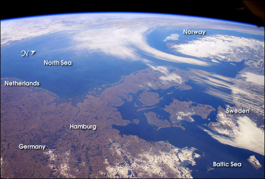
Mission: ISS006 Roll: E Frame: 33901 Mission ID on the Film or image: ISS006Country or Geographic Name: DENMARK
Features: PAN-JUTLAND PENINSULA, SCANDINAVIA
Center Point Latitude: 56.0 Center Point Longitude: 9.0 (Negative numbers indicate south for latitude and west for longitude)
Stereo: (Yes indicates there is an adjacent picture of the same area)
ONC Map ID: JNC Map ID:
Camera
Camera Tilt: High ObliqueCamera Focal Length: 28mm
Camera: E4: Kodak DCS760C Electronic Still Camera
Film: 3060E : 3060 x 2036 pixel CCD, RGBG array.
Quality
Film Exposure:Percentage of Cloud Cover: 25 (11-25)
Nadir
Date: 20030226 (YYYYMMDD)GMT Time: 094734 (HHMMSS)Nadir Point Latitude: 51.5, Longitude: 12.1 (Negative numbers indicate south for latitude and west for longitude)
Nadir to Photo Center Direction: Northwest
Sun Azimuth: 153 (Clockwise angle in degrees from north to the sun measured at the nadir point)
Spacecraft Altitude: 211 nautical miles (391 km)
Sun Elevation Angle: 26 (Angle in degrees between the horizon and the sun, measured at the nadir point)
Orbit Number: 372
Captions
The Kingdom of Denmark, with an area of 16,639 square miles, consists of the Jutland Peninsula and roughly 500 islands. It is also a part of the generally fertile and mostly agricultural region known as the North European Plain. This entire region is generally flat to slightly rolling and is overlain with deposits of Pleistocene glaciers. (The Pleistocene lasted from 1.8 million to 11,000 years ago, during which time several ice ages occured.)Taking advantage of remarkably fair weather over north central Europe for this time of year, the crew of the International Space Station took this panoramic view that extends from the North Sea coast of the Netherlands on the left to the Baltic Sea shores of Sweden on the right. The late-winter landscape has little snow cover except over northeastern Germany, Sweden, and the rugged mountains of Norway. Such images, composed by astronauts, provide unique, synoptic perspectives of the Earth’s geography and natural processes.
Download Packaged File.
This option downloads the following items, packaged into a single file, if they are available:
- Browse image
- Cataloged information with captions
- Camera file
- Sound file
Server: 2 |
This service is provided by the International Space Station program. |
Recommended Citation: |
||

