| Home >> | Advanced Search >> |
 |
|
Astronaut Photography of Earth - Display Record
ISS006-E-33736
Low-resolution Browse Image
(Most browse images are not color adjusted.)Images
Conditions for Use of Images >>Image Transformation Tutorial >> Saving, Color Adjusting, and Printing Images >>
Images to View on Your Computer Now
| File Name | File Size (bytes) | Width | Height | Annotated | Cropped | Purpose | Comments | |
|---|---|---|---|---|---|---|---|---|
| View | ISS006-E-33736.JPG | 46122 | 540 | 354 | Photographic Highlights | (540 px resized images) | ||
| View | ISS006-E-33736.JPG | 47185 | 540 | 346 | Yes | Yes | NASA's Earth Observatory web site | Color adjusted |
| View | ISS006-E-33736.JPG | 47185 | 540 | 346 | Yes | Yes | NASA's Earth Observatory web site | |
| View | ISS006-E-33736.JPG | 67313 | 639 | 435 | No | No | ||
| View | ISS006-E-33736.JPG | 266489 | 1000 | 640 | No | No | NASA's Earth Observatory web site |
Large Images to Request for Downloading
| File Name | File Size (bytes) | Width | Height | Annotated | Cropped | Purpose | Comments | |
|---|---|---|---|---|---|---|---|---|
| Request | ISS006-E-33736.JPG | 173243 | 1024 | 671 | Photographic Highlights | (actual files used) | ||
| Request | ISS006-E-33736.JPG | 1136082 | 3032 | 2064 | No | No |
Download a Keyhole Markup Language (KML) file for use in Google Earth.
Electronic Image Data
Camera Files >> No sound file available.Identification
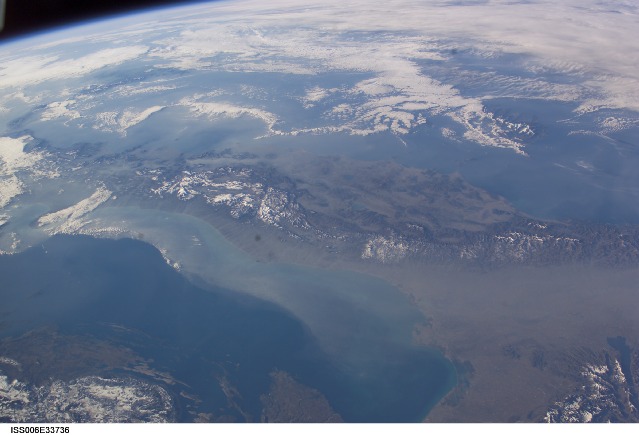
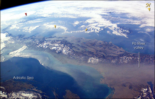
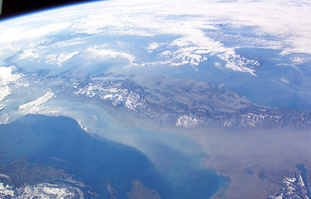
Mission: ISS006 Roll: E Frame: 33736 Mission ID on the Film or image: ISS006Country or Geographic Name: ITALY
Features: PAN-APENNINES, PO VALLEY, HAZE
Center Point Latitude: 43.0 Center Point Longitude: 13.0 (Negative numbers indicate south for latitude and west for longitude)
Stereo: (Yes indicates there is an adjacent picture of the same area)
ONC Map ID: JNC Map ID:
Camera
Camera Tilt: 49Camera Focal Length: 28mm
Camera: E4: Kodak DCS760C Electronic Still Camera
Film: 3060E : 3060 x 2036 pixel CCD, RGBG array.
Quality
Film Exposure:Percentage of Cloud Cover: 25 (11-25)
Nadir
Date: 20030225 (YYYYMMDD)GMT Time: 073106 (HHMMSS)Nadir Point Latitude: 46.7, Longitude: 11.2 (Negative numbers indicate south for latitude and west for longitude)
Nadir to Photo Center Direction: South
Sun Azimuth: 119 (Clockwise angle in degrees from north to the sun measured at the nadir point)
Spacecraft Altitude: 212 nautical miles (393 km)
Sun Elevation Angle: 13 (Angle in degrees between the horizon and the sun, measured at the nadir point)
Orbit Number: 355
Captions
The boot of Italy crosses the image in this southwest-looking view taken by the crew of the International Space Station. The spine of Italy is highlighted with snow and the largely cloud-covered Mediterranean Sea is at the top. The Adriatic Sea transverses most of the bottom of the image and Sicily appears top left beyond the toe of the boot (red arrow). The heel lies out of the left side of the image. Corsica and Sardinia appear right of center partly under cloud.The floor of the Po River valley, lower right, is obscured by haze. Experience gained from similar haze events, in which atmospheric pressure, humidity and visibility and atmospheric chemistry were known, suggests that the haze is industrial smog. Industrial haze from the urban region of the central and upper Po valley accumulates to visible concentrations under conditions of high atmospheric pressure and the surrounding mountains prevent easy dispersal. This view illustrates the markedly different color and texture of cloud versus industrial aerosol haze.
The flow pattern is typical of that seen on most Shuttle flights since the early 1980s and often recorded on film, that is of slow transport of the smog-rich airmass eastward into the Adriatic basin. This is the easiest and largest exit for haze moving away from the industrial region. The sharp seaward edge of the coherent plume of haze parallels the coastline of Italy—the coast can be discerned through the haze, from Venice (lower right) as far as the Gargano Peninsula (left margin, partly hidden under cloud). Note how there is sufficient lift along this seaward edge to generate a small cloud.
There appears to be a smaller haze mass accumulating on the east side of the Apennines between Naples and Cassino (yellow arrows).
Download Packaged File.
This option downloads the following items, packaged into a single file, if they are available:
- Browse image
- Cataloged information with captions
- Camera file
- Sound file
Server: 2 |
This service is provided by the International Space Station program. |
Recommended Citation: |
||

