| Home >> | Advanced Search >> |
 |
|
Astronaut Photography of Earth - Display Record
STS092-713-32

Low-resolution Browse Image
(Most browse images are not color adjusted.)Images
Conditions for Use of Images >>Image Transformation Tutorial >> Saving, Color Adjusting, and Printing Images >>
Images to View on Your Computer Now
| File Name | File Size (bytes) | Width | Height | Annotated | Cropped | Purpose | Comments | |
|---|---|---|---|---|---|---|---|---|
| View | STS092-713-32.JPG | 52539 | 517 | 512 | No | No | From ISD PhotoCDs | |
| View | STS092-713-32.JPG | 76873 | 540 | 540 | Yes | No | NASA's Earth Observatory web site | |
| View | STS092-713-32.JPG | 1604759 | 2591 | 2583 | No | No | NASA's Earth Observatory web site | |
| View | STS092-713-32_2.JPG | 77164 | 400 | 399 | No | Photographic Highlights |
Large Images to Request for Downloading
| File Name | File Size (bytes) | Width | Height | Annotated | Cropped | Purpose | Comments | |
|---|---|---|---|---|---|---|---|---|
| Request | STS092-713-32.JPG | 161270 | 1035 | 1024 | No | No | From ISD PhotoCDs | |
| Request | STS092-713-32_2.JPG | 478640 | 2071 | 2048 | No | No | From ISD PhotoCDs | |
| Request | STS092-713-32_3.JPG | 1296084 | 4143 | 4096 | No | No | From ISD PhotoCDs | |
| Request | STS092-713-32.TIF | 20084073 | 2591 | 2583 | No | No |
Download a Keyhole Markup Language (KML) file for use in Google Earth.
Electronic Image Data
Camera files only apply to electronic still cameras.No sound file available.
Identification
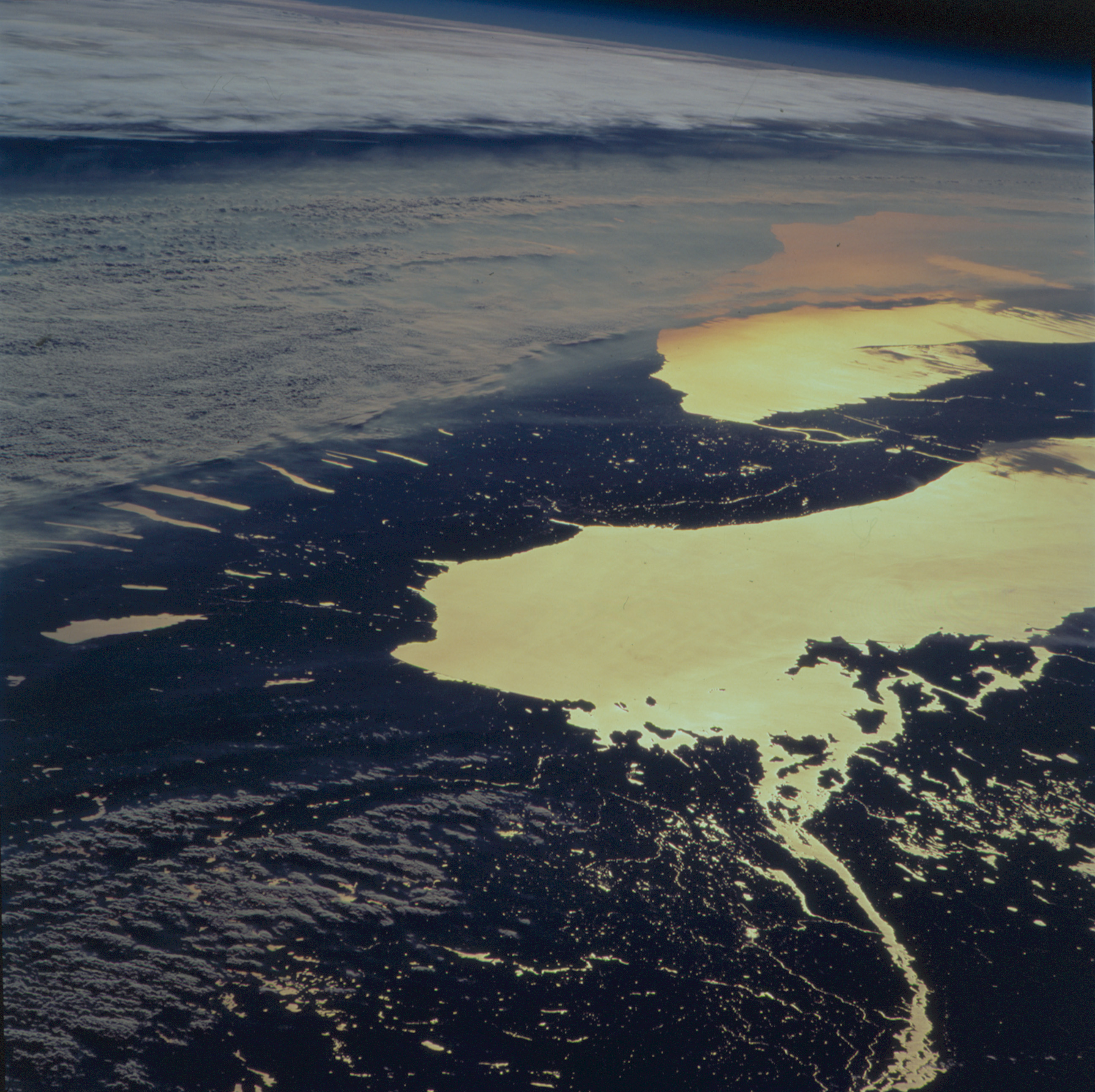
Mission: STS092 Roll: 713 Frame: 32 Mission ID on the Film or image: STS92Country or Geographic Name: USA-NEW YORK
Features: PAN-LAKE ONTARIO, SMOG, SUNGLINT
Center Point Latitude: 43.5 Center Point Longitude: -77.0 (Negative numbers indicate south for latitude and west for longitude)
Stereo: (Yes indicates there is an adjacent picture of the same area)
ONC Map ID: JNC Map ID:
Camera
Camera Tilt: High ObliqueCamera Focal Length: 250mm
Camera: HB: Hasselblad
Film: 5069 : Kodak Elite 100S, E6 Reversal, Replaces Lumiere, Warmer in tone vs. Lumiere.
Quality
Film Exposure:Percentage of Cloud Cover: 50 (26-50)
Nadir
Date: 20001021 (YYYYMMDD)GMT Time: 204237 (HHMMSS)Nadir Point Latitude: 48.1, Longitude: -64.6 (Negative numbers indicate south for latitude and west for longitude)
Nadir to Photo Center Direction: West
Sun Azimuth: 248 (Clockwise angle in degrees from north to the sun measured at the nadir point)
Spacecraft Altitude: 202 nautical miles (374 km)
Sun Elevation Angle: 5 (Angle in degrees between the horizon and the sun, measured at the nadir point)
Orbit Number: 156
Captions
The STS-92 Space Shuttle astronauts photographed upstate New York at sunset on October 21, 2000. Water bodies (Lake Ontario, Lake Erie, the Finger Lakes, the St. Lawrence and Niagara Rivers) are highlighted by sunglint (sun reflecting off the water surface), making for a dramatic and unusual regional view.The photograph was taken looking toward the southwest from southern Canada, and captures a regional smog layer extending across central New York, western Lake Erie and Ohio, and further west. The layer of atmospheric pollution layer is capped by an atmospheric inversion, which is marked by the layer of clouds at the top of the photograph. The astronauts were able to document this smog event from a variety of vantage points as they orbited over the northeastern U.S. and southern Canada.
Download Packaged File.
This option downloads the following items, packaged into a single file, if they are available:
- Browse image
- Cataloged information with captions
- Camera file
- Sound file
Server: 2 |
This service is provided by the International Space Station program. |
Recommended Citation: |
||

