| Home >> | Advanced Search >> |
 |
|
Astronaut Photography of Earth - Display Record
ISS009-E-28346

Low-resolution Browse Image
(Most browse images are not color adjusted.)Images
Conditions for Use of Images >>Image Transformation Tutorial >> Saving, Color Adjusting, and Printing Images >>
Images to View on Your Computer Now
| File Name | File Size (bytes) | Width | Height | Annotated | Cropped | Purpose | Comments | |
|---|---|---|---|---|---|---|---|---|
| View | ISS009-E-28346.JPG | 63389 | 639 | 435 | No | No | ||
| View | ISS009-E-28346.JPG | 254541 | 357 | 540 | Yes | Yes | Earth From Space collection | |
| View | ISS009-E-28346.JPG | 724658 | 1000 | 661 | No | Yes | NASA's Earth Observatory web site |
Large Images to Request for Downloading
| File Name | File Size (bytes) | Width | Height | Annotated | Cropped | Purpose | Comments | |
|---|---|---|---|---|---|---|---|---|
| Request | ISS009-E-28346.JPG | 886764 | 3032 | 2064 | No | No |
Download a Keyhole Markup Language (KML) file for use in Google Earth.
Electronic Image Data
Camera Files >> No sound file available.Identification
Mission: ISS009 Roll: E Frame: 28346 Mission ID on the Film or image: ISS009Country or Geographic Name: USA-WASHINGTON
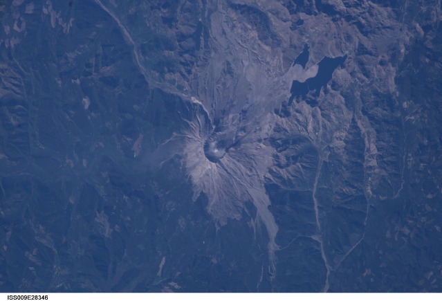
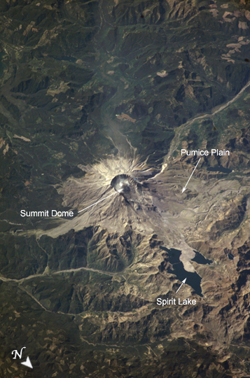
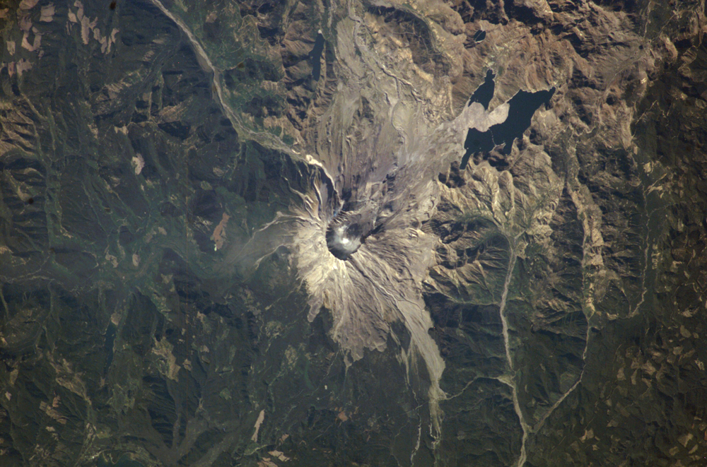
Features: MT. ST. HELENS, STEAM
Center Point Latitude: 46.2 Center Point Longitude: -122.2 (Negative numbers indicate south for latitude and west for longitude)
Stereo: (Yes indicates there is an adjacent picture of the same area)
ONC Map ID: JNC Map ID:
Camera
Camera Tilt: 45Camera Focal Length: 400mm
Camera: E4: Kodak DCS760C Electronic Still Camera
Film: 3060E : 3060 x 2036 pixel CCD, RGBG array.
Quality
Film Exposure:Percentage of Cloud Cover: 10 (0-10)
Nadir
Date: 20041013 (YYYYMMDD)GMT Time: 195348 (HHMMSS)Nadir Point Latitude: 47.2, Longitude: -119.1 (Negative numbers indicate south for latitude and west for longitude)
Nadir to Photo Center Direction: West
Sun Azimuth: 183 (Clockwise angle in degrees from north to the sun measured at the nadir point)
Spacecraft Altitude: 193 nautical miles (357 km)
Sun Elevation Angle: 35 (Angle in degrees between the horizon and the sun, measured at the nadir point)
Orbit Number: 1695
Captions
Steam Plume, Mount St. HelensEarly in October 2004 Mt. St. Helens rumbled back to life with earthquakes, minor eruptions of steam and ash, and renewed growth of the summit lava dome. Fortuitous trajectories of the International Space Station provided the ISS crew excellent views of the area, and they proceeded to collect a suite of images of Mount St. Helens over several days from different vantage points. This south-viewing image was acquired on October 13, 2004 following recent steam eruptions; two white steam plumes are visible to the south of the summit dome. While lava dome growth continues the current eruptive activity has not significantly altered the morphology of the volcano. Several mudflows and deposition of minor amounts of ash close to the cone have occurred as a result of current activity.
The main features visible in this image are the result of a cataclysmic 1980 eruption resulting from landslide failure of the northern flank of the volcano. The resulting directed blast of suddenly exposed gas-rich magma devastated a region of 20 km to the north and raised the bed level of Spirit Lake by 60 meters. The grayish Pumice Plain is mainly comprised of pyroclastic and mudflow deposits from the 1980 eruption. Today, the volcano is being intensively monitored by United States Geological Survey scientists for indications of further increases in activity and hazard potential.
Download Packaged File.
This option downloads the following items, packaged into a single file, if they are available:
- Browse image
- Cataloged information with captions
- Camera file
- Sound file
Server: 2 |
This service is provided by the International Space Station program. |
Recommended Citation: |
||

