| Home >> | Advanced Search >> |
 |
|
Astronaut Photography of Earth - Display Record
STS113-347-28

Low-resolution Browse Image
(Most browse images are not color adjusted.)Images
Conditions for Use of Images >>Image Transformation Tutorial >> Saving, Color Adjusting, and Printing Images >>
Images to View on Your Computer Now
| File Name | File Size (bytes) | Width | Height | Annotated | Cropped | Purpose | Comments | |
|---|---|---|---|---|---|---|---|---|
| View | STS113-347-28.JPG | 27234 | 515 | 342 | No | No | From ISD highres, sharpened | |
| View | STS113-347-28.JPG | 91491 | 540 | 540 | Yes | Yes | NASA's Earth Observatory web site | |
| View | STS113-347-28.JPG | 315209 | 540 | 405 | Photographic Highlights | (540 px resized image) | ||
| View | STS113-347-28.JPG | 1323428 | 1000 | 1143 | No | No | NASA's Earth Observatory web site |
Large Images to Request for Downloading
| File Name | File Size (bytes) | Width | Height | Annotated | Cropped | Purpose | Comments | |
|---|---|---|---|---|---|---|---|---|
| Request | STS113-347-28_3.JPG | 420048 | 1024 | 768 | Photographic Highlights | (actual files used) | ||
| Request | STS113-347-28.JPG | 586261 | 3070 | 2044 | No | No | From ISD TGA images | |
| Request | STS113-347-28_2.JPG | 978805 | 1024 | 768 | Photographic Highlights | (actual files used) | ||
| Request | STS113-347-28.TIF | 2876263 | 1200 | 798 | No | No | Photographic Highlights | From ISD TGA images |
Download a Keyhole Markup Language (KML) file for use in Google Earth.
Electronic Image Data
Camera files only apply to electronic still cameras.No sound file available.
Identification
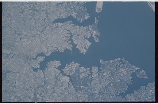
Mission: STS113 Roll: 347 Frame: 28 Mission ID on the Film or image: STS113Country or Geographic Name: USA-MARYLAND
Features: BALTIMORE, SNOW
Center Point Latitude: 39.5 Center Point Longitude: -76.5 (Negative numbers indicate south for latitude and west for longitude)
Stereo: (Yes indicates there is an adjacent picture of the same area)
ONC Map ID: JNC Map ID:
Camera
Camera Tilt: 35Camera Focal Length: mm
Camera: HB: Hasselblad
Film: 5069 : Kodak Elite 100S, E6 Reversal, Replaces Lumiere, Warmer in tone vs. Lumiere.
Quality
Film Exposure:Percentage of Cloud Cover: 10 (0-10)
Nadir
Date: 20021206 (YYYYMMDD)GMT Time: 202422 (HHMMSS)Nadir Point Latitude: 40.0, Longitude: -74.1 (Negative numbers indicate south for latitude and west for longitude)
Nadir to Photo Center Direction: West
Sun Azimuth: 229 (Clockwise angle in degrees from north to the sun measured at the nadir point)
Spacecraft Altitude: 212 nautical miles (393 km)
Sun Elevation Angle: 10 (Angle in degrees between the horizon and the sun, measured at the nadir point)
Orbit Number: 201
Captions
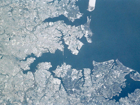
STS113-347-28 Baltimore, Maryland, USA December 2002While traveling to the International Space Station aboard the Space Shuttle Endeavor, astronauts photographed the northeastern United States blanketed in fresh snow. This image, taken in early December 2002, shows the city of Baltimore, and the surrounding area. An inset shows the center of the city (rotated so north points up--see Earth Observatory image posting.
Astronauts routinely track weather phenomena on Earth, and use their onboard cameras to document their observations. Ground support in the Earth Observations Lab at the Johnson Space Center also track weather events world wide as part of the image planning activities, and alert the crews to significant events such as winter storm systems.
Download Packaged File.
This option downloads the following items, packaged into a single file, if they are available:
- Browse image
- Cataloged information with captions
- Camera file
- Sound file
Server: 2 |
This service is provided by the International Space Station program. |
Recommended Citation: |
||

