| Home >> | Advanced Search >> |
 |
|
Astronaut Photography of Earth - Display Record
ISS013-E-27590

Low-resolution Browse Image
(Most browse images are not color adjusted.)Images
Conditions for Use of Images >>Image Transformation Tutorial >> Saving, Color Adjusting, and Printing Images >>
Images to View on Your Computer Now
| File Name | File Size (bytes) | Width | Height | Annotated | Cropped | Purpose | Comments | |
|---|---|---|---|---|---|---|---|---|
| View | ISS013-E-27590.JPG | 66196 | 639 | 435 | No | No | ||
| View | ISS013-E-27590.JPG | 272536 | 540 | 345 | Yes | Yes | NASA's Earth Observatory web site |
Large Images to Request for Downloading
| File Name | File Size (bytes) | Width | Height | Annotated | Cropped | Purpose | Comments | |
|---|---|---|---|---|---|---|---|---|
| Request | ISS013-E-27590.JPG | 836708 | 1000 | 638 | No | Yes | NASA's Earth Observatory web site | |
| Request | ISS013-E-27590.JPG | 1281204 | 3032 | 2064 | No | No |
Download a Keyhole Markup Language (KML) file for use in Google Earth.
Electronic Image Data
Camera Files >> No sound file available.Identification
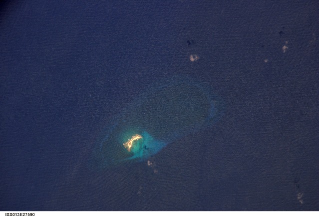
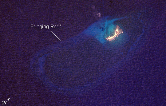
Mission: ISS013 Roll: E Frame: 27590 Mission ID on the Film or image: ISS013Country or Geographic Name: CARIBBEAN SEA
Features: AVES ISLAND, CORAL REEFS
Center Point Latitude: 15.7 Center Point Longitude: -63.6 (Negative numbers indicate south for latitude and west for longitude)
Stereo: (Yes indicates there is an adjacent picture of the same area)
ONC Map ID: JNC Map ID:
Camera
Camera Tilt: 7Camera Focal Length: 800mm
Camera: E4: Kodak DCS760C Electronic Still Camera
Film: 3060E : 3060 x 2036 pixel CCD, RGBG array.
Quality
Film Exposure:Percentage of Cloud Cover: 10 (0-10)
Nadir
Date: 20060527 (YYYYMMDD)GMT Time: 183252 (HHMMSS)Nadir Point Latitude: 16.0, Longitude: -63.8 (Negative numbers indicate south for latitude and west for longitude)
Nadir to Photo Center Direction: Southeast
Sun Azimuth: 285 (Clockwise angle in degrees from north to the sun measured at the nadir point)
Spacecraft Altitude: 185 nautical miles (343 km)
Sun Elevation Angle: 56 (Angle in degrees between the horizon and the sun, measured at the nadir point)
Orbit Number: 2994
Captions
Aves IslandNamed Isla de Aves in Spanish, (meaning “Island of the Birds”) Aves Island lies west of the Lesser Antilles in the Caribbean. It provides a nesting site to green sea turtles (Chelonia mydas) and, of course, birds. Because the abundant bird droppings, known as guano, could be used in fertilizer and gunpowder, guano miners worked on the island until they depleted the supply. Since its discovery by Europeans, likely in the late 16th century, Aves Island was subsequently claimed by several European nations. The island is currently claimed by Venezuela, although disputes about ownership of the island, and the surrounding exclusive economic zone in the Caribbean, continue today.
Aves Island is small—only 0.5 by 0.2 kilometers (0.3 by 0.1 miles)—and its highest point stands just 4 meters (13 feet) above sea level. In hurricanes, the island can be completely submerged. In 1980, Hurricane Allen split the island in two, but subsequent coral reef growth reunited the two halves. This astronaut photograph is a rare, almost cloud-free, view of the island and the submerged fringing coral reef that surrounds it. The fringing reef is barely visible, appearing as a ring slightly lighter in color than the ocean water. The crosshatch-like pattern of roughness on the surrounding sea surface is most likely caused by variable winds at the time of image acquisition.
Download Packaged File.
This option downloads the following items, packaged into a single file, if they are available:
- Browse image
- Cataloged information with captions
- Camera file
- Sound file
Server: 2 |
This service is provided by the International Space Station program. |
Recommended Citation: |
||

