| Home >> | Advanced Search >> |
 |
|
Astronaut Photography of Earth - Display Record
ISS012-E-23057

Low-resolution Browse Image
(Most browse images are not color adjusted.)Images
Conditions for Use of Images >>Image Transformation Tutorial >> Saving, Color Adjusting, and Printing Images >>
Images to View on Your Computer Now
| File Name | File Size (bytes) | Width | Height | Annotated | Cropped | Purpose | Comments | |
|---|---|---|---|---|---|---|---|---|
| View | ISS012-E-23057.JPG | 78995 | 639 | 435 | No | No | ||
| View | ISS012-E-23057.JPG | 351628 | 540 | 477 | Yes | Yes | NASA's Earth Observatory web site |
Large Images to Request for Downloading
| File Name | File Size (bytes) | Width | Height | Annotated | Cropped | Purpose | Comments | |
|---|---|---|---|---|---|---|---|---|
| Request | ISS012-E-23057.JPG | 1046650 | 3032 | 2064 | No | No | ||
| Request | ISS012-E-23057.JPG | 1083816 | 1000 | 884 | No | Yes | NASA's Earth Observatory web site |
Download a Keyhole Markup Language (KML) file for use in Google Earth.
Electronic Image Data
Camera Files >> No sound file available.Identification
Mission: ISS012 Roll: E Frame: 23057 Mission ID on the Film or image: ISS012Country or Geographic Name: NAMIBIA
Features: ETOSHA PAN DRY LAKE, INLET
Center Point Latitude: -18.5 Center Point Longitude: 16.0 (Negative numbers indicate south for latitude and west for longitude)
Stereo: (Yes indicates there is an adjacent picture of the same area)
ONC Map ID: JNC Map ID:
Camera
Camera Tilt: 8Camera Focal Length: 180mm
Camera: E4: Kodak DCS760C Electronic Still Camera
Film: 3060E : 3060 x 2036 pixel CCD, RGBG array.
Quality
Film Exposure:Percentage of Cloud Cover: 10 (0-10)
Nadir
Date: 20060302 (YYYYMMDD)GMT Time: 122108 (HHMMSS)Nadir Point Latitude: -18.1, Longitude: 15.9 (Negative numbers indicate south for latitude and west for longitude)
Nadir to Photo Center Direction: South
Sun Azimuth: 299 (Clockwise angle in degrees from north to the sun measured at the nadir point)
Spacecraft Altitude: 186 nautical miles (344 km)
Sun Elevation Angle: 69 (Angle in degrees between the horizon and the sun, measured at the nadir point)
Orbit Number: 1634
Captions
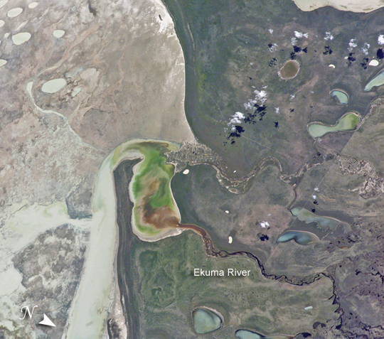
Ekuma River and Etosha Pan, NamibiaHigh-resolution Images:
March 2, 2006 (320 kB JPEG)
June 24, 2005 (380 kB JPEG)
Etosha Pan in northern Namibia is a large, dry lakebed in the Kalahari Desert. The 120-kilometer-long (75-mile-long) lake and its surroundings are protected as one of Namibia’s largest wildlife parks. Herds of elephants occupy the dense mopane woodland on the south side of the lake. Mopane trees are common throughout south-central Africa, and host the mopane worm, which is the larval form of the Mopane Emperor Moth and an important source of protein for rural communities. About 16,000 years ago, when ice sheets were melting across Northern Hemisphere land masses, a wet climate phase in southern Africa filled Etosha Lake. Today, Etosha Pan is seldom seen with even a thin sheet of water covering the salt pan.
Two images taken about nine months apart document an unusually wet summer in southern Africa. The upper view (March 2006) shows the point where the Ekuma River flows into the salt lake; the lower regional image (June 2005) shows the same inlet—but dry—on the north shore of Etosha Pan. The Ekuma River is almost never seen with water, but in early 2006, rainfall twice the average amount in the river’s catchment generated flow. Greens and browns show vegetation and algae growing in different depths of water where the river enters the dry lake (upper image, center). Typically, little river water or sediment reaches the dry lake because water seeps into the riverbed along its 250-kilometer (55-mile) course, reducing discharge along the way. In this image, there was enough surface flow to reach the Etosha Pan, but too little water reached the mouth of the river to flow beyond the inlet bay. The unusual levels of precipitation also filled several small, usually dry lakes to the north (upper image, right).
Download Packaged File.
This option downloads the following items, packaged into a single file, if they are available:
- Browse image
- Cataloged information with captions
- Camera file
- Sound file
Server: 2 |
This service is provided by the International Space Station program. |
Recommended Citation: |
||

