| Home >> | Advanced Search >> |
 |
|
Astronaut Photography of Earth - Display Record
ISS009-E-20440

Low-resolution Browse Image
(Most browse images are not color adjusted.)Images
Conditions for Use of Images >>Image Transformation Tutorial >> Saving, Color Adjusting, and Printing Images >>
Images to View on Your Computer Now
| File Name | File Size (bytes) | Width | Height | Annotated | Cropped | Purpose | Comments | |
|---|---|---|---|---|---|---|---|---|
| View | ISS009-E-20440.JPG | 35057 | 540 | 334 | No | NASA's Earth Observatory web site | ||
| View | ISS009-E-20440.JPG | 79683 | 639 | 435 | No | No |
Large Images to Request for Downloading
| File Name | File Size (bytes) | Width | Height | Annotated | Cropped | Purpose | Comments | |
|---|---|---|---|---|---|---|---|---|
| Request | ISS009-E-20440.JPG | 1018763 | 3032 | 2064 | No | No |
Download a Keyhole Markup Language (KML) file for use in Google Earth.
Electronic Image Data
Camera Files >> No sound file available.Identification
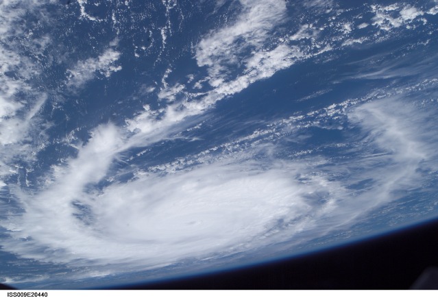
Mission: ISS009 Roll: E Frame: 20440 Mission ID on the Film or image: ISS009Country or Geographic Name: ATLANTIC OCEAN
Features: PAN-HURRICANE FRANCES
Center Point Latitude: 15.0 Center Point Longitude: -49.0 (Negative numbers indicate south for latitude and west for longitude)
Stereo: (Yes indicates there is an adjacent picture of the same area)
ONC Map ID: JNC Map ID:
Camera
Camera Tilt: High ObliqueCamera Focal Length: 35mm
Camera: E4: Kodak DCS760C Electronic Still Camera
Film: 3060E : 3060 x 2036 pixel CCD, RGBG array.
Quality
Film Exposure:Percentage of Cloud Cover: 50 (26-50)
Nadir
Date: 20040827 (YYYYMMDD)GMT Time: 140210 (HHMMSS)Nadir Point Latitude: 5.8, Longitude: -50.0 (Negative numbers indicate south for latitude and west for longitude)
Nadir to Photo Center Direction: North
Sun Azimuth: 77 (Clockwise angle in degrees from north to the sun measured at the nadir point)
Spacecraft Altitude: 195 nautical miles (361 km)
Sun Elevation Angle: 70 (Angle in degrees between the horizon and the sun, measured at the nadir point)
Orbit Number: 953
Captions
Hurricane Frances:(27 August 2004) --- This photo of Hurricane Frances was taken by Astronaut Mike Fincke aboard the International Space Station as he flew 230 statute miles above the storm at about 9 a.m. CDT Friday, Aug. 27, 2004. At the time, Frances was located 820 miles east of the Lesser Antilles in the Atlantic Ocean, moving west-northwest at 10 miles per hour, with maximum sustained winds of 105 miles per hour. Fincke, the NASA ISS Science Officer and Flight Engineer, and Expedition 9 Commander Gennady Padalka are in the fifth month of a six-month flight aboard the Station.
Download Packaged File.
This option downloads the following items, packaged into a single file, if they are available:
- Browse image
- Cataloged information with captions
- Camera file
- Sound file
Server: 2 |
This service is provided by the International Space Station program. |
Recommended Citation: |
||

