| Home >> | Advanced Search >> |
 |
|
Astronaut Photography of Earth - Display Record
ISS010-E-20111

Low-resolution Browse Image
(Most browse images are not color adjusted.)Images
Conditions for Use of Images >>Image Transformation Tutorial >> Saving, Color Adjusting, and Printing Images >>
Images to View on Your Computer Now
| File Name | File Size (bytes) | Width | Height | Annotated | Cropped | Purpose | Comments | |
|---|---|---|---|---|---|---|---|---|
| View | ISS010-E-20111.JPG | 70288 | 639 | 435 | No | No | ||
| View | ISS010-E-20111.JPG | 401771 | 540 | 406 | Yes | Yes | Earth From Space collection | |
| View | ISS010-E-20111.JPG | 1317539 | 1000 | 751 | No | Yes | NASA's Earth Observatory web site |
Large Images to Request for Downloading
| File Name | File Size (bytes) | Width | Height | Annotated | Cropped | Purpose | Comments | |
|---|---|---|---|---|---|---|---|---|
| Request | ISS010-E-20111.JPG | 1093706 | 3032 | 2064 | No | No |
Download a Keyhole Markup Language (KML) file for use in Google Earth.
Electronic Image Data
Camera Files >> No sound file available.Identification
Mission: ISS010 Roll: E Frame: 20111 Mission ID on the Film or image: ISS010Country or Geographic Name: PERU
Features: LIMA,PARK VEGETATION
Center Point Latitude: -12.1 Center Point Longitude: -77.0 (Negative numbers indicate south for latitude and west for longitude)
Stereo: (Yes indicates there is an adjacent picture of the same area)
ONC Map ID: JNC Map ID:
Camera
Camera Tilt: 22Camera Focal Length: 800mm
Camera: E4: Kodak DCS760C Electronic Still Camera
Film: 3060E : 3060 x 2036 pixel CCD, RGBG array.
Quality
Film Exposure:Percentage of Cloud Cover: 10 (0-10)
Nadir
Date: 20050317 (YYYYMMDD)GMT Time: 172459 (HHMMSS)Nadir Point Latitude: -10.9, Longitude: -76.5 (Negative numbers indicate south for latitude and west for longitude)
Nadir to Photo Center Direction: South
Sun Azimuth: 345 (Clockwise angle in degrees from north to the sun measured at the nadir point)
Spacecraft Altitude: 194 nautical miles (359 km)
Sun Elevation Angle: 80 (Angle in degrees between the horizon and the sun, measured at the nadir point)
Orbit Number: 129
Captions
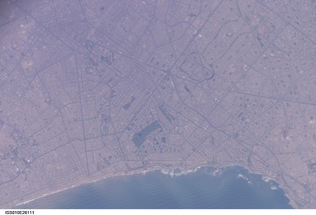
Lima Metropolitan Area, PeruLocated on the broad alluvial fan of the Rimac River, Lima is the capital of Peru and the only megacity (7.7 million inhabitants in 2002) located on the western coastline of South America. The city was established by Francisco Pizarro in 1535 and became an important colonial port, linking silver mines of the Altiplano of the high Andes Mountains with the burgeoning Spanish empire. During the mid-20th century, significant numbers of people relocated from rural mountain communities into the Lima metropolitan area. Problems now facing the metropolitan region include developing adequate water resources, controlling pollution, and preparing for natural hazards such as earthquakes and landslides.
This astronaut photograph depicts the wealthier San Isidro and Miraflores quarters of Lima. This part of the metropolitan area is characterized by numerous vegetated parks, golf courses (such as the Lima Golf Course—approximately 1 km long), and greenbelts interspersed with residential and commercial areas. The higher proportion of dark asphalt in the street grid of the residential and commercial areas lends a purple coloration to the left portion of the astronaut photograph (downtown Lima is to the north). Regions with fewer built materials and vegetation are light tan. Wave patterns are visible approaching beaches, popular tourist destinations, in the lower half of the image.
Download Packaged File.
This option downloads the following items, packaged into a single file, if they are available:
- Browse image
- Cataloged information with captions
- Camera file
- Sound file
Server: 2 |
This service is provided by the International Space Station program. |
Recommended Citation: |
||

