| Home >> | Advanced Search >> |
 |
|
Astronaut Photography of Earth - Display Record
ISS008-E-19273

Low-resolution Browse Image
(Most browse images are not color adjusted.)Images
Conditions for Use of Images >>Image Transformation Tutorial >> Saving, Color Adjusting, and Printing Images >>
Images to View on Your Computer Now
| File Name | File Size (bytes) | Width | Height | Annotated | Cropped | Purpose | Comments | |
|---|---|---|---|---|---|---|---|---|
| View | ISS008-E-19273.JPG | 44410 | 639 | 435 | No | No | ||
| View | ISS008-E-19273.JPG | 104197 | 540 | 540 | Yes | Yes | NASA's Earth Observatory web site | |
| View | ISS008-E-19273_2.JPG | 398886 | 1000 | 662 | No | No | NASA's Earth Observatory web site | |
| View | ISS008-E-19273.JPG | 1273517 | 1000 | 850 | No | Yes | NASA's Earth Observatory web site | Color adjusted |
Large Images to Request for Downloading
| File Name | File Size (bytes) | Width | Height | Annotated | Cropped | Purpose | Comments | |
|---|---|---|---|---|---|---|---|---|
| Request | ISS008-E-19273.JPG | 738751 | 3032 | 2064 | No | No | ||
| Request | ISS008-E-19273.JPG | 2060325 | 3032 | 1992 | No | No | Dust marks removed | |
| Request | ISS008-E-19273.JPG | 4774436 | 3032 | 1992 | No | No | NASA's Earth Observatory web site | Color adjusted |
Download a Keyhole Markup Language (KML) file for use in Google Earth.
Electronic Image Data
Camera Files >> No sound file available.Identification
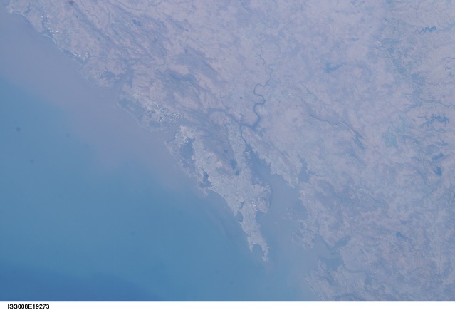
Mission: ISS008 Roll: E Frame: 19273 Mission ID on the Film or image: ISS008Country or Geographic Name: INDIA
Features: BOMBAY, HARBOR, KALU RIVER, MTS.
Center Point Latitude: 19.0 Center Point Longitude: 73.0 (Negative numbers indicate south for latitude and west for longitude)
Stereo: (Yes indicates there is an adjacent picture of the same area)
ONC Map ID: JNC Map ID:
Camera
Camera Tilt: 23Camera Focal Length: 80mm
Camera: E4: Kodak DCS760C Electronic Still Camera
Film: 3060E : 3060 x 2036 pixel CCD, RGBG array.
Quality
Film Exposure:Percentage of Cloud Cover: 10 (0-10)
Nadir
Date: 20040325 (YYYYMMDD)GMT Time: 101528 (HHMMSS)Nadir Point Latitude: 20.1, Longitude: 72.2 (Negative numbers indicate south for latitude and west for longitude)
Nadir to Photo Center Direction: Southeast
Sun Azimuth: 253 (Clockwise angle in degrees from north to the sun measured at the nadir point)
Spacecraft Altitude: 195 nautical miles (361 km)
Sun Elevation Angle: 43 (Angle in degrees between the horizon and the sun, measured at the nadir point)
Orbit Number: 2517
Captions
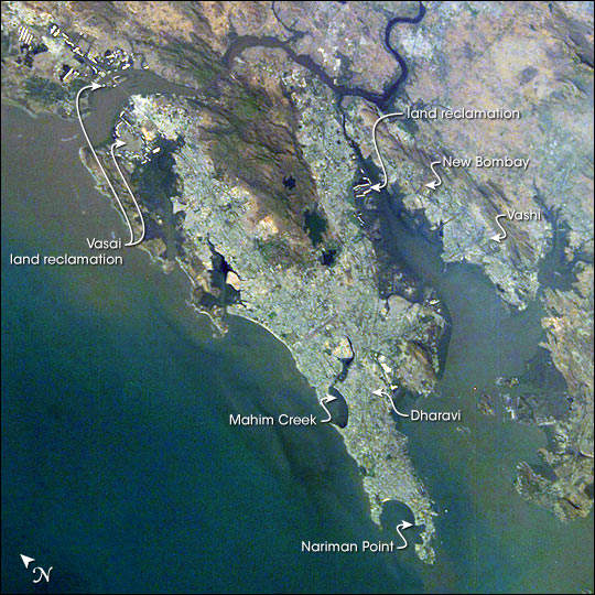
Mumbai, India:With almost 23 million residents, Mumbai, India, is the second largest city in the world (only Tokyo, Japan, is larger than Mumbai). Rapid population growth in Mumbai is evident in this image from the International Space Station that shows several regions of the city with active land reclamation activities on its coasts, bays and hinterlands. Mumbai exemplifies the global urban growth and sprawl seen in recent years as human populations throughout the world continue to migrate to cities. The UN reports that 48 percent of the world’s population lived in urban areas in 2003. CNN quotes the report as saying that the proportion of urban-to-rural dwellers is “expected to exceed the 50 percent mark by 2007, thus marking the first time in history that the world will have more urban residents than rural residents.”
Historically, this region was called “Mumba” after local deity “Mumbadevi” and consisted of seven islands joined together by series of reclamations. In 1543, the region fell to the Portuguese who named their possession “Bom Baia,” which translates as “good bay.” In 1662, the English King Charles II received these islands as a dowry on his marriage to the Portuguese princess, and the islands acquired the name “Bombay.” In recent years, the city has reclaimed its local name “Mumbai.”
Hailed as India’s financial capital and center of her film industry, Mumbai is a city that reflects modern progress and potential. Nariman Point is the hub of economic and financial activity; its skyline has often been compared to Manhattan’s. Mumbai’s docklands comprise the largest port in the entire subcontinent and handle over 25 percent of India’s international trade. But the rapid growth also results in growing public health issues such as air pollution. Adjacent to the commercial sector is Asia’s largest slum, known as Dharavi. It is noteworthy that Dharavi has its own industrial and handicraft trade that annually contributes about one billion dollars to Mumbai’s economy. New urbanized areas such as Vashi, New Bombay, Vasai, and Mahim Creek are being developed to ease this congestion and provide space for new suburbs and industrial parks.
Download Packaged File.
This option downloads the following items, packaged into a single file, if they are available:
- Browse image
- Cataloged information with captions
- Camera file
- Sound file
Server: 2 |
This service is provided by the International Space Station program. |
Recommended Citation: |
||

