| Home >> | Advanced Search >> |
 |
|
Astronaut Photography of Earth - Display Record
ISS016-E-18385

Low-resolution Browse Image
(Most browse images are not color adjusted.)Images
Conditions for Use of Images >>Image Transformation Tutorial >> Saving, Color Adjusting, and Printing Images >>
Images to View on Your Computer Now
| File Name | File Size (bytes) | Width | Height | Annotated | Cropped | Purpose | Comments | |
|---|---|---|---|---|---|---|---|---|
| View | ISS016-E-18385.JPG | 70908 | 639 | 435 | No | No | ||
| View | ISS016-E-18385.JPG | 259193 | 540 | 379 | Yes | Yes | NASA's Earth Observatory web site |
Large Images to Request for Downloading
| File Name | File Size (bytes) | Width | Height | Annotated | Cropped | Purpose | Comments | |
|---|---|---|---|---|---|---|---|---|
| Request | ISS016-E-18385.JPG | 725444 | 1000 | 702 | No | Yes | NASA's Earth Observatory web site | |
| Request | ISS016-E-18385.JPG | 1109979 | 3032 | 2064 | No | No |
Download a Keyhole Markup Language (KML) file for use in Google Earth.
Electronic Image Data
Camera Files >> No sound file available.Identification
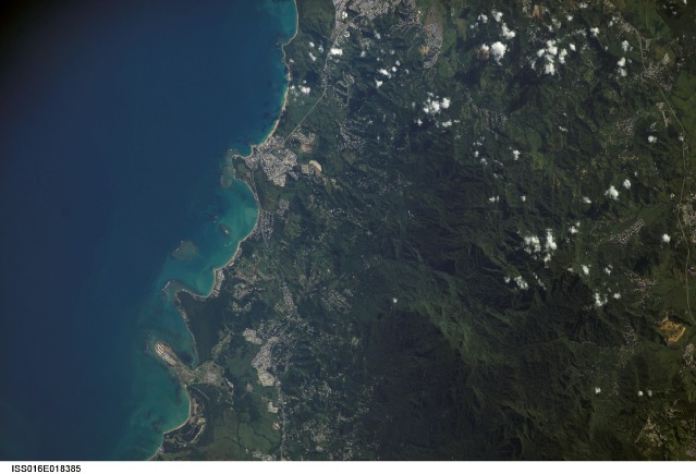
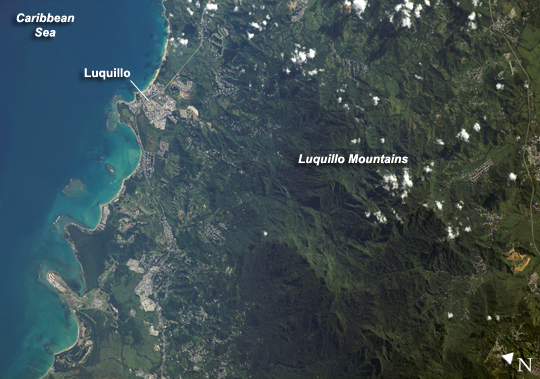
Mission: ISS016 Roll: E Frame: 18385 Mission ID on the Film or image: ISS016Country or Geographic Name: PUERTO RICO
Features: LUQUILLO,LUQUILLO MOUNTAINS
Center Point Latitude: 18.3 Center Point Longitude: -65.8 (Negative numbers indicate south for latitude and west for longitude)
Stereo: (Yes indicates there is an adjacent picture of the same area)
ONC Map ID: JNC Map ID:
Camera
Camera Tilt: 33Camera Focal Length: 400mm
Camera: E4: Kodak DCS760C Electronic Still Camera
Film: 3060E : 3060 x 2036 pixel CCD, RGBG array.
Quality
Film Exposure:Percentage of Cloud Cover: 10 (0-10)
Nadir
Date: 20071223 (YYYYMMDD)GMT Time: 131337 (HHMMSS)Nadir Point Latitude: 18.1, Longitude: -67.7 (Negative numbers indicate south for latitude and west for longitude)
Nadir to Photo Center Direction: East
Sun Azimuth: 129 (Clockwise angle in degrees from north to the sun measured at the nadir point)
Spacecraft Altitude: 180 nautical miles (333 km)
Sun Elevation Angle: 27 (Angle in degrees between the horizon and the sun, measured at the nadir point)
Orbit Number: 65
Captions
Luquillo Mountains, Puerto RicoThe Luquillo Mountains are located in the northeastern portion of Puerto Rico, and they rise to elevations of 1,075 meters (about 3,527 feet). The mountains are mainly made up of volcanic rock that was uplifted by tectonic activity between approximately 37–28 million years ago. (Puerto Rico is located between the junction of the North American and Caribbean tectonic plates.) Prevailing easterly winds bring moisture from the Caribbean Sea, which becomes precipitation as the winds cross the mountains. Higher elevations receive more rainfall than lower elevations, leading to subtropical forest types in the lowlands and high-mountain forest types near the summits. This astronaut photograph, taken during the rainy season, illustrates the rich vegetation on the mountains.
The rapid transition between ecosystems based on elevation, along with land use history and exposure to frequent natural disturbances such as hurricanes, makes the Luquillo Mountains an ideal location for ecological study. The Luquillo Experimental Forest Long-Term Ecological Research (LTER) site is contained within the Luquillo National Forest, covering much of the mountains to the southwest of the city of Luquillo (lower left). Past human activities, including logging, agriculture, charcoal production, and coffee plantations, have determined much of the current ecosystem structure. Results of research at Luquillo Forest indicate that the island’s forest ecosystems recover more rapidly from natural disturbances (like hurricanes) than they do from human disturbance.
Download Packaged File.
This option downloads the following items, packaged into a single file, if they are available:
- Browse image
- Cataloged information with captions
- Camera file
- Sound file
Server: 2 |
This service is provided by the International Space Station program. |
Recommended Citation: |
||

