| Home >> | Advanced Search >> |
 |
|
Astronaut Photography of Earth - Display Record
ISS007-E-18088

Low-resolution Browse Image
(Most browse images are not color adjusted.)Images
Conditions for Use of Images >>Image Transformation Tutorial >> Saving, Color Adjusting, and Printing Images >>
Images to View on Your Computer Now
| File Name | File Size (bytes) | Width | Height | Annotated | Cropped | Purpose | Comments | |
|---|---|---|---|---|---|---|---|---|
| View | ISS007-E-18088.JPG | 45186 | 540 | 354 | Photographic Highlights | (resized 540 px images) | ||
| View | ISS007-E-18088.JPG | 45386 | 540 | 334 | No | Yes | NASA's Earth Observatory web site | |
| View | ISS007-E-18088.JPG | 45386 | 540 | 334 | No | Yes | NASA's Earth Observatory web site | |
| View | ISS007-E-18088.JPG | 51440 | 639 | 435 | No | No | ||
| View | ISS007-E-18088_2.JPG | 129971 | 997 | 653 | Photographic Highlights | (actual files used) |
Large Images to Request for Downloading
| File Name | File Size (bytes) | Width | Height | Annotated | Cropped | Purpose | Comments | |
|---|---|---|---|---|---|---|---|---|
| Request | ISS007-E-18088_2.JPG | 594016 | 1000 | 681 | No | Yes | NASA's Earth Observatory web site | |
| Request | ISS007-E-18088.JPG | 722153 | 3032 | 2064 | No | No | ||
| Request | ISS007-E-18088.JPG | 3161209 | 3032 | 2064 | No | No | NASA's Earth Observatory web site | color corrected |
| Request | ISS007-E-18088_2.JPG | 3594772 | 6144 | 4068 | No | No | Presentation | Earth Sciences Results Briefing/Ed Lu |
Download a Keyhole Markup Language (KML) file for use in Google Earth.
Electronic Image Data
Camera Files >> No sound file available.Identification
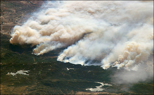
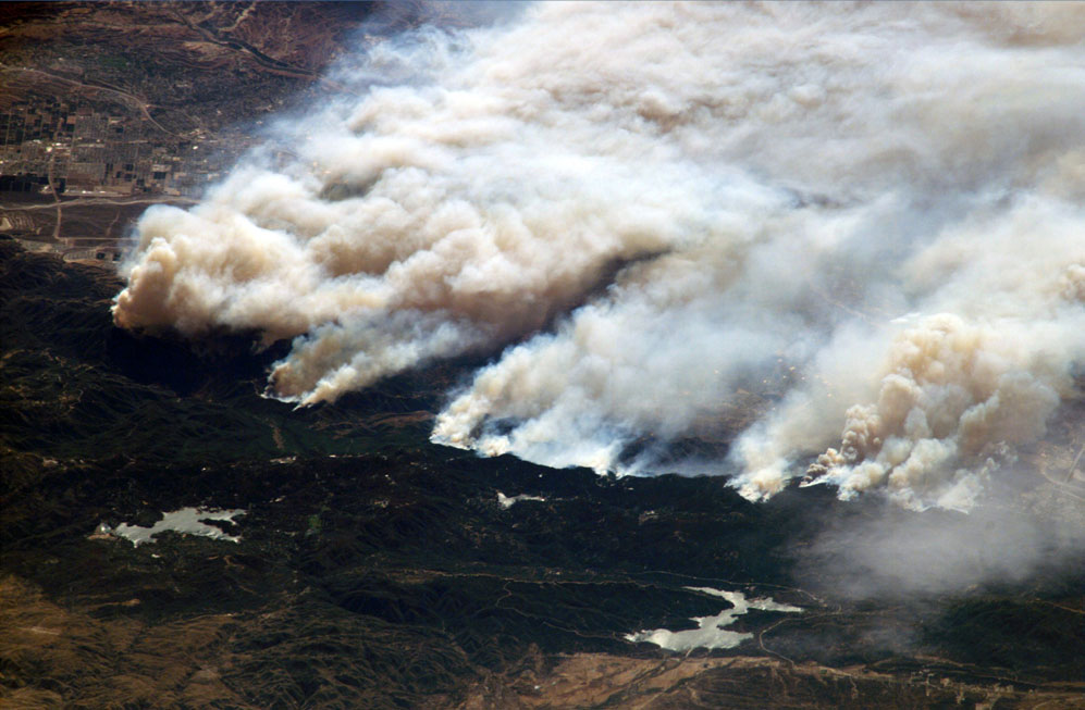
Mission: ISS007 Roll: E Frame: 18088 Mission ID on the Film or image: ISS007Country or Geographic Name: USA-CALIFORNIA
Features: FIRE SMOKE, SAN BERNARDINO MTS.
Center Point Latitude: 34.0 Center Point Longitude: -117.5 (Negative numbers indicate south for latitude and west for longitude)
Stereo: (Yes indicates there is an adjacent picture of the same area)
ONC Map ID: JNC Map ID:
Camera
Camera Tilt: High ObliqueCamera Focal Length: 800mm
Camera: E4: Kodak DCS760C Electronic Still Camera
Film: 3060E : 3060 x 2036 pixel CCD, RGBG array.
Quality
Film Exposure:Percentage of Cloud Cover: 10 (0-10)
Nadir
Date: 20031026 (YYYYMMDD)GMT Time: 195426 (HHMMSS)Nadir Point Latitude: 41.1, Longitude: -120.0 (Negative numbers indicate south for latitude and west for longitude)
Nadir to Photo Center Direction: South
Sun Azimuth: 183 (Clockwise angle in degrees from north to the sun measured at the nadir point)
Spacecraft Altitude: 200 nautical miles (370 km)
Sun Elevation Angle: 37 (Angle in degrees between the horizon and the sun, measured at the nadir point)
Orbit Number: 157
Captions
Fires in Southern CaliforniaFires in the San Bernadino Mountains, driven by Santa Ana winds, burned out of control Sunday morning when these images were taken from the International Space Station (ISS) at roughly 11 a.m. PST. Thick yellow smoke blows south, blanketing the valley below. This photgraph, looking southeast, captures the smoke pall as the ISS approached and passed over the region. Lake Arrowhead is the reservoir near the left edge of the phtograph.
A mosaic comprised of several photogaphs shows the breadth of the fires. A small break in the smoke near the center of the images marks Cajon pass. The mosaic contains photographs ISS007-E-18086, ISS007-E-18087, and ISS007-E-18088.
Download Packaged File.
This option downloads the following items, packaged into a single file, if they are available:
- Browse image
- Cataloged information with captions
- Camera file
- Sound file
Server: 2 |
This service is provided by the International Space Station program. |
Recommended Citation: |
||

