| Home >> | Advanced Search >> |
 |
|
Astronaut Photography of Earth - Display Record
ISS005-E-18035

Low-resolution Browse Image
(Most browse images are not color adjusted.)Images
Conditions for Use of Images >>Image Transformation Tutorial >> Saving, Color Adjusting, and Printing Images >>
Images to View on Your Computer Now
| File Name | File Size (bytes) | Width | Height | Annotated | Cropped | Purpose | Comments | |
|---|---|---|---|---|---|---|---|---|
| View | ISS005-E-18035.JPG | 93677 | 540 | 540 | Yes | Yes | NASA's Earth Observatory web site | |
| View | ISS005-E-18035.JPG | 112055 | 639 | 435 | No | No | From STIC, color adjusted | |
| View | ISS005-E-18035.JPG | 329106 | 540 | 357 | Photographic Highlights | (540 px resized images) | ||
| View | ISS005-E-18035.JPG | 1078170 | 1000 | 662 | No | No | NASA's Earth Observatory web site | |
| View | ISS005-E-18035_2.JPG | 1195709 | 997 | 660 | Photographic Highlights | (actual files used) |
Large Images to Request for Downloading
| File Name | File Size (bytes) | Width | Height | Annotated | Cropped | Purpose | Comments | |
|---|---|---|---|---|---|---|---|---|
| Request | ISS005-E-18035.JPG | 1884402 | 3032 | 2064 | No | No | From STIC, color adjusted |
Download a Keyhole Markup Language (KML) file for use in Google Earth.
Electronic Image Data
Camera Files >> No sound file available.Identification
Mission: ISS005 Roll: E Frame: 18035 Mission ID on the Film or image: ISS005Country or Geographic Name: CUBA
Features: LA HAVANA
Center Point Latitude: 23.0 Center Point Longitude: -82.5 (Negative numbers indicate south for latitude and west for longitude)
Stereo: (Yes indicates there is an adjacent picture of the same area)
ONC Map ID: JNC Map ID:
Camera
Camera Tilt: 15Camera Focal Length: 800mm
Camera: E4: Kodak DCS760C Electronic Still Camera
Film: 3060E : 3060 x 2036 pixel CCD, RGBG array.
Quality
Film Exposure:Percentage of Cloud Cover: 10 (0-10)
Nadir
Date: 20021022 (YYYYMMDD)GMT Time: 134157 (HHMMSS)Nadir Point Latitude: 23.1, Longitude: -83.4 (Negative numbers indicate south for latitude and west for longitude)
Nadir to Photo Center Direction: East
Sun Azimuth: 117 (Clockwise angle in degrees from north to the sun measured at the nadir point)
Spacecraft Altitude: 208 nautical miles (385 km)
Sun Elevation Angle: 27 (Angle in degrees between the horizon and the sun, measured at the nadir point)
Orbit Number: 2394
Captions
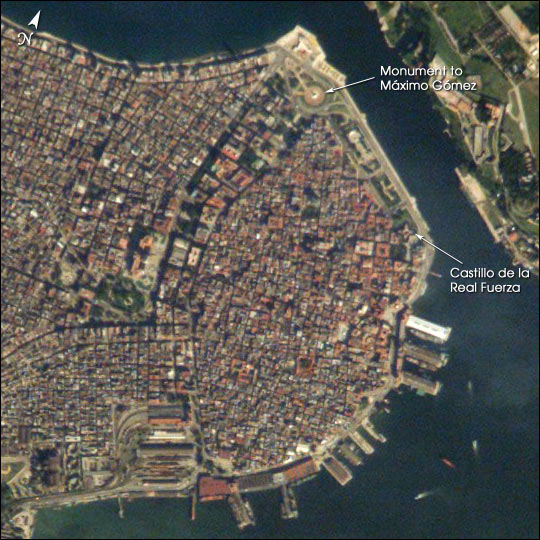
The red tile roofs and historic buildings of Cuba’s Old Havana appear distinctly in this high-resolution photograph taken by astronauts on board the International Space Station. Founded by the Spanish in 1519, the old city was strongly fortified against attacks by pirates. Some of these fortifications, such as the Castillo de la Real Fuerza, are readily distinguishable at the 6-m/pixel resolution of the photograph, which is displayed here in actual pixels. The complete image includes most of the rest of modern Havana as well.Download Packaged File.
This option downloads the following items, packaged into a single file, if they are available:
- Browse image
- Cataloged information with captions
- Camera file
- Sound file
Server: 2 |
This service is provided by the International Space Station program. |
Recommended Citation: |
||

