| Home >> | Advanced Search >> |
 |
|
Astronaut Photography of Earth - Display Record
ISS007-E-14745

Low-resolution Browse Image
(Most browse images are not color adjusted.)Images
Conditions for Use of Images >>Image Transformation Tutorial >> Saving, Color Adjusting, and Printing Images >>
Images to View on Your Computer Now
| File Name | File Size (bytes) | Width | Height | Annotated | Cropped | Purpose | Comments | |
|---|---|---|---|---|---|---|---|---|
| View | ISS007-E-14745.JPG | 28837 | 540 | 354 | Photographic Highlights | (resized 540 px images) | ||
| View | ISS007-E-14745.JPG | 38174 | 639 | 435 | No | No | ||
| View | ISS007-E-14745_2.JPG | 45889 | 540 | 356 | Yes | NASA's Earth Observatory web site | ||
| View | ISS007-E-14745.JPG | 108960 | 540 | 356 | Scientist Request | Online Publication | ||
| View | ISS007-E-14745_2.JPG | 110883 | 998 | 655 | Photographic Highlights | (actual files used) | ||
| View | ISS007-E-14745.JPG | 197564 | 540 | 339 | No | Yes | NASA's Earth Observatory web site | Color adjusted |
| View | ISS007-E-14745.JPG | 197564 | 540 | 339 | No | No | NASA's Earth Observatory web site | |
| View | ISS007-E-14745.JPG | 435389 | 1000 | 659 | No | Yes | NASA's Earth Observatory web site | Color adjusted |
Large Images to Request for Downloading
| File Name | File Size (bytes) | Width | Height | Annotated | Cropped | Purpose | Comments | |
|---|---|---|---|---|---|---|---|---|
| Request | ISS007-E-14745.JPG | 535796 | 3032 | 2064 | No | No | ||
| Request | ISS007-E-14745.JPG | 1475371 | 3032 | 1998 | No | No | Color adjusted | |
| Request | ISS007-E-14745_2.JPG | 2678212 | 6144 | 4068 | No | No | Presentation | Earth Sciences Results Briefing/Ed Lu |
Download a Keyhole Markup Language (KML) file for use in Google Earth.
Electronic Image Data
Camera Files >> No sound file available.Identification
Mission: ISS007 Roll: E Frame: 14745 Mission ID on the Film or image: ISS007Country or Geographic Name: ATLANTIC OCEAN
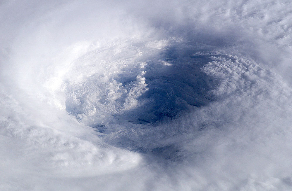
Features: HURRICANE ISABEL, EYE DETAIL
Center Point Latitude: 22.5 Center Point Longitude: -62.0 (Negative numbers indicate south for latitude and west for longitude)
Stereo: (Yes indicates there is an adjacent picture of the same area)
ONC Map ID: JNC Map ID:
Camera
Camera Tilt: High ObliqueCamera Focal Length: 180mm
Camera: E4: Kodak DCS760C Electronic Still Camera
Film: 3060E : 3060 x 2036 pixel CCD, RGBG array.
Quality
Film Exposure:Percentage of Cloud Cover: 100 (76-100)
Nadir
Date: 20030913 (YYYYMMDD)GMT Time: 111844 (HHMMSS)Nadir Point Latitude: 17.7, Longitude: -60.7 (Negative numbers indicate south for latitude and west for longitude)
Nadir to Photo Center Direction: North
Sun Azimuth: 92 (Clockwise angle in degrees from north to the sun measured at the nadir point)
Spacecraft Altitude: 204 nautical miles (378 km)
Sun Elevation Angle: 20 (Angle in degrees between the horizon and the sun, measured at the nadir point)
Orbit Number: 3479
Captions
Astronaut Ed Lu snapped this photo of the eye of Hurricane Isabel from the International Space Station on September 13, 2003 at 11:18 UTC. At the time, Isabel was located about 450 miles northeast of Puerto Rico. It had dropped to a Category 4 hurricane on the Saffir-Simpson Hurricane Scale, packing winds of 150 miles per hour with gusts up to 184 miles per hour.After originating in the eastern Atlantic west of the Cape Verde Islands, Isabel became the second major hurricane of the 2003 Atlantic season when it was declared a Category 3 storm by the National Hurricane Center on September 8. Over the next four days, Isabel strengthened into an extremely powerful Category 5 hurricane with winds estimated at 160 mph before weakening as it approached the eastern seaboard of the US.
Why Unique: This photo shows the structure of Isabel's eyewall. No other sensor images the eyewalls of hurricane with such detail. Previous work using images from the Shuttle of the eyewall of Hurricane Amleia allowed three dimensional studies of the eyewall structure.
These images were used by the National Hurricane Center, NOAA, the Weather Channel and many other media organizations covering the news story.
ISS007-E-14745, ESC with 180mm lens, 13 September 2003 at 11:18 UTC.
The Gateway to Astronaut Photography of Earth, http://eol.jsc.nasa.gov
Download Packaged File.
This option downloads the following items, packaged into a single file, if they are available:
- Browse image
- Cataloged information with captions
- Camera file
- Sound file
Server: 2 |
This service is provided by the International Space Station program. |
Recommended Citation: |
||

