| Home >> | Advanced Search >> |
 |
|
Astronaut Photography of Earth - Display Record
ISS009-E-12441

Low-resolution Browse Image
(Most browse images are not color adjusted.)Images
Conditions for Use of Images >>Image Transformation Tutorial >> Saving, Color Adjusting, and Printing Images >>
Images to View on Your Computer Now
| File Name | File Size (bytes) | Width | Height | Annotated | Cropped | Purpose | Comments | |
|---|---|---|---|---|---|---|---|---|
| View | ISS009-E-12441.JPG | 39198 | 639 | 435 | No | No | ||
| View | ISS009-E-12441.JPG | 305106 | 540 | 356 | Yes | Yes | Earth From Space collection | |
| View | ISS009-E-12441.JPG | 928456 | 1000 | 660 | No | Yes | NASA's Earth Observatory web site |
Large Images to Request for Downloading
| File Name | File Size (bytes) | Width | Height | Annotated | Cropped | Purpose | Comments | |
|---|---|---|---|---|---|---|---|---|
| Request | ISS009-E-12441.JPG | 702382 | 3032 | 2064 | No | No |
Download a Keyhole Markup Language (KML) file for use in Google Earth.
Electronic Image Data
Camera Files >> No sound file available.Identification
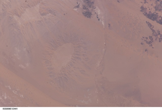
Mission: ISS009 Roll: E Frame: 12441 Mission ID on the Film or image: ISS009Country or Geographic Name: EGYPT
Features: GEBEL EDMONSTONE, DUNES
Center Point Latitude: 25.6 Center Point Longitude: 28.7 (Negative numbers indicate south for latitude and west for longitude)
Stereo: (Yes indicates there is an adjacent picture of the same area)
ONC Map ID: JNC Map ID:
Camera
Camera Tilt: 13Camera Focal Length: 400mm
Camera: E4: Kodak DCS760C Electronic Still Camera
Film: 3060E : 3060 x 2036 pixel CCD, RGBG array.
Quality
Film Exposure:Percentage of Cloud Cover: 10 (0-10)
Nadir
Date: 20040618 (YYYYMMDD)GMT Time: 120050 (HHMMSS)Nadir Point Latitude: 26.0, Longitude: 29.3 (Negative numbers indicate south for latitude and west for longitude)
Nadir to Photo Center Direction: Southwest
Sun Azimuth: 271 (Clockwise angle in degrees from north to the sun measured at the nadir point)
Spacecraft Altitude: 194 nautical miles (359 km)
Sun Elevation Angle: 63 (Angle in degrees between the horizon and the sun, measured at the nadir point)
Orbit Number: 3852
Captions
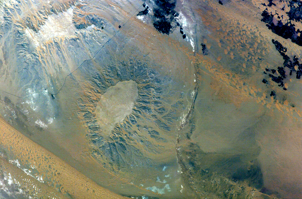
Gebel (or Mount) Edmonstone is a flat-topped mesa located near the Dahkla Oasis south of Cairo, Egypt. The Oasis is a historically important meeting place of several trade routes connecting different regions of Egypt and Sudan. Gebel Edmonstone is a remnant of an eroding scarp that extends for over 200 kilometers (125 miles) east-southeast to west-northwest (visible in the upper left corner of the image). The flat caprock of both the scarp and Mount Edmonstone is chalky limestone underlain by fossil-bearing shale and fine-grained sedimentary rocks.Digital astronaut photographs can be processed in similar fashion to other multispectral remotely sensed data to maximize information content. This astronaut photograph has been "stretched" to enhance color variations in the various rock and soil units. The color variations reflect differences in composition (or weathering) of the various rock units. The limestone unit capping Gebel Edmonstone and the adjacent scarp ranges from white to gray in color, while the underlaying fine-grained sedimentary layers are blue-gray. Hillslope pathways for sediment movement downslope are clearly visible as brown to tan streamers originating from Gebel Edmonstone. Barchan dune fields are also visible in this color-enhanced image, and are distinct due to their mineralogical composition. Evaporite deposits are bright white, while vegetated portions of the Oasis—mostly agricultural fields—are dark blue-black. This additional information obtained from image enhancement can be used for geologic mapping and investigation of surficial processes operating in the region.
Download Packaged File.
This option downloads the following items, packaged into a single file, if they are available:
- Browse image
- Cataloged information with captions
- Camera file
- Sound file
Server: 2 |
This service is provided by the International Space Station program. |
Recommended Citation: |
||

