| Home >> | Advanced Search >> |
 |
|
Astronaut Photography of Earth - Display Record
ISS017-E-11632
Low-resolution Browse Image
(Most browse images are not color adjusted.)Images
Conditions for Use of Images >>Image Transformation Tutorial >> Saving, Color Adjusting, and Printing Images >>
Images to View on Your Computer Now
| File Name | File Size (bytes) | Width | Height | Annotated | Cropped | Purpose | Comments | |
|---|---|---|---|---|---|---|---|---|
| View | ISS017-E-11632.JPG | 37464 | 640 | 437 | No | No | ||
| View | ISS017-E-11632.JPG | 120718 | 540 | 355 | No | Yes | NASA's Earth Observatory web site |
Large Images to Request for Downloading
| File Name | File Size (bytes) | Width | Height | Annotated | Cropped | Purpose | Comments | |
|---|---|---|---|---|---|---|---|---|
| Request | ISS017-E-11632.JPG | 339930 | 1000 | 658 | No | Yes | NASA's Earth Observatory web site | |
| Request | ISS017-E-11632.JPG | 383540 | 3072 | 2098 | No | No |
Download a Keyhole Markup Language (KML) file for use in Google Earth.
Electronic Image Data
Camera Files >> No sound file available.Identification
Mission: ISS017 Roll: E Frame: 11632 Mission ID on the Film or image: ISS017Country or Geographic Name: ASIA
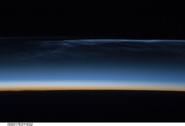
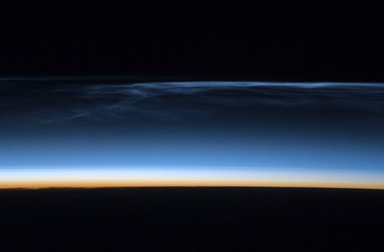
Features: PAN-NOCTILUCENT CLOUDS
Center Point Latitude: Center Point Longitude: (Negative numbers indicate south for latitude and west for longitude)
Stereo: (Yes indicates there is an adjacent picture of the same area)
ONC Map ID: JNC Map ID:
Camera
Camera Tilt: High ObliqueCamera Focal Length: 180mm
Camera: N2: Nikon D2Xs
Film: 4288E : 4288 x 2848 pixel CMOS sensor, RGBG imager color filter.
Quality
Film Exposure:Percentage of Cloud Cover: 10 (0-10)
Nadir
Date: 20080722 (YYYYMMDD)GMT Time: 182401 (HHMMSS)Nadir Point Latitude: 48.9, Longitude: 92.2 (Negative numbers indicate south for latitude and west for longitude)
Nadir to Photo Center Direction:
Sun Azimuth: 7 (Clockwise angle in degrees from north to the sun measured at the nadir point)
Spacecraft Altitude: 181 nautical miles (335 km)
Sun Elevation Angle: -21 (Angle in degrees between the horizon and the sun, measured at the nadir point)
Orbit Number: 3413
Captions
Polar Mesospheric Clouds over Central AsiaPolar mesospheric clouds (also known as noctilucent, or “night-shining” clouds) are transient, upper atmospheric phenomena that are usually observed in the summer months at high latitudes (greater than 50 degrees) of both the Northern and Southern Hemispheres. They appear bright and cloudlike while in deep twilight. They are illuminated by sunlight when the lower layers of the atmosphere are in the darkness of Earth’s shadow.
This astronaut photograph of polar mesospheric clouds was acquired at an altitude of just over 200 miles (about 321 kilometers) in the pre-dawn hours (18:24:01 Greenwich Mean Time) on July 22, 2008, as the International Space Station was passing over western Mongolia in central Asia. The dark horizon of the Earth appears at the bottom of the image, with some layers of the lower atmosphere already illuminated by the rising Sun. The higher, bluish-colored clouds look much like wispy cirrus clouds, which can be found as high as 60,000 feet (18 kilometers) in the atmosphere. However noctilucent clouds, as seen here, are observed in the mesosphere at altitudes of 250,000 to 280,000 feet (about 76 to 85 kilometers).
Astronaut observations of polar mesospheric clouds over northern Asia in June and July are not uncommon. The crew of the International Space Station acquired this image and many others in support of research for the International Polar Year. Some researchers link increased observations of these clouds to changes in global climate. Polar mesospheric clouds have been the subject of extensive observation and research from space by the Swedish satellite Odin, launched in 2001, and more recently by NASA’s Aeronomy of Ice in the Mesosphere (AIM) satellite system beginning in 2007.
Download Packaged File.
This option downloads the following items, packaged into a single file, if they are available:
- Browse image
- Cataloged information with captions
- Camera file
- Sound file
Server: 2 |
This service is provided by the International Space Station program. |
Recommended Citation: |
||

