| Home >> | Advanced Search >> |
 |
|
Astronaut Photography of Earth - Display Record
ISS016-E-10894

Low-resolution Browse Image
(Most browse images are not color adjusted.)Images
Conditions for Use of Images >>Image Transformation Tutorial >> Saving, Color Adjusting, and Printing Images >>
Images to View on Your Computer Now
| File Name | File Size (bytes) | Width | Height | Annotated | Cropped | Purpose | Comments | |
|---|---|---|---|---|---|---|---|---|
| View | ISS016-E-10894.JPG | 77639 | 639 | 435 | No | No | ||
| View | ISS016-E-10894.JPG | 314397 | 540 | 378 | Yes | Yes | NASA's Earth Observatory web site |
Large Images to Request for Downloading
| File Name | File Size (bytes) | Width | Height | Annotated | Cropped | Purpose | Comments | |
|---|---|---|---|---|---|---|---|---|
| Request | ISS016-E-10894.JPG | 945208 | 1000 | 700 | No | Yes | NASA's Earth Observatory web site | |
| Request | ISS016-E-10894.JPG | 1119530 | 3032 | 2064 | No | No |
Download a Keyhole Markup Language (KML) file for use in Google Earth.
Electronic Image Data
Camera Files >> No sound file available.Identification
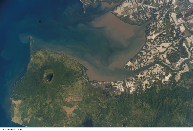
Mission: ISS016 Roll: E Frame: 10894 Mission ID on the Film or image: ISS016Country or Geographic Name: NICARAGUA
Features: GULF OF FONSECA,SHRIMP FARMS
Center Point Latitude: 13.0 Center Point Longitude: -87.4 (Negative numbers indicate south for latitude and west for longitude)
Stereo: (Yes indicates there is an adjacent picture of the same area)
ONC Map ID: JNC Map ID:
Camera
Camera Tilt: 2Camera Focal Length: 180mm
Camera: E4: Kodak DCS760C Electronic Still Camera
Film: 3060E : 3060 x 2036 pixel CCD, RGBG array.
Quality
Film Exposure:Percentage of Cloud Cover: 10 (0-10)
Nadir
Date: 20071117 (YYYYMMDD)GMT Time: 153324 (HHMMSS)Nadir Point Latitude: 13.0, Longitude: -87.5 (Negative numbers indicate south for latitude and west for longitude)
Nadir to Photo Center Direction: East
Sun Azimuth: 136 (Clockwise angle in degrees from north to the sun measured at the nadir point)
Spacecraft Altitude: 183 nautical miles (339 km)
Sun Elevation Angle: 46 (Angle in degrees between the horizon and the sun, measured at the nadir point)
Orbit Number: 3498
Captions
Cosiguina Volcano, NicaraguaThree Central American countries—El Salvador, Honduras, and Nicaragua—have coastline along the Gulf of Fonseca, which opens into the Pacific Ocean. The southern boundary of the Gulf is a peninsula formed by the Cosigüina Volcano. Cosigüina is a stratovolcano, which is a cone-shaped volcano formed by alternating layers of solidified lava and volcanic rocks produced by explosive eruptions. The summit crater is filled with a lake (Laguna Cosigüina). The volcano last erupted in 1859, but its most famous activity occurred in 1835, when it produced the largest historical eruption in Nicaragua. Ash from the 1835 eruption has been found in Mexico, Costa Rica, and Jamaica.
The volcano has been quiet since 1859, only an instant in terms of geological time. An earthquake swarm was measured near Cosigüina in 2002, indicating that tectonic forces are still active in the region although the volcano is somewhat isolated from the line of more recently active Central American volcanoes to the northwest and southeast. The only indicators of hydrothermal activity at the volcano are intermittently observed gas bubbles in Laguna Cosigüina and a hot spring along the eastern flank of the volcano. The fairly uniform vegetation cover (green) on the volcano’s sides also attest to a general lack of gas emissions or “hot spots” on the 872-meter-high cone.
Download Packaged File.
This option downloads the following items, packaged into a single file, if they are available:
- Browse image
- Cataloged information with captions
- Camera file
- Sound file
Server: 2 |
This service is provided by the International Space Station program. |
Recommended Citation: |
||

