| Home >> | Advanced Search >> |
 |
|
Astronaut Photography of Earth - Display Record
ISS011-E-10575
Low-resolution Browse Image
(Most browse images are not color adjusted.)Images
Conditions for Use of Images >>Image Transformation Tutorial >> Saving, Color Adjusting, and Printing Images >>
Images to View on Your Computer Now
| File Name | File Size (bytes) | Width | Height | Annotated | Cropped | Purpose | Comments | |
|---|---|---|---|---|---|---|---|---|
| View | ISS011-E-10575.JPG | 65416 | 639 | 435 | No | No | ||
| View | ISS011-E-10575.JPG | 350883 | 540 | 357 | Yes | Yes | NASA's Earth Observatory web site |
Large Images to Request for Downloading
| File Name | File Size (bytes) | Width | Height | Annotated | Cropped | Purpose | Comments | |
|---|---|---|---|---|---|---|---|---|
| Request | ISS011-E-10575.JPG | 1079690 | 1000 | 661 | No | Yes | NASA's Earth Observatory web site | |
| Request | ISS011-E-10575.JPG | 1156624 | 3032 | 2008 | No | No | Not enhanced | Converted to JPEG from a raw image |
Download a Keyhole Markup Language (KML) file for use in Google Earth.
Electronic Image Data
Camera Files >> No sound file available.Identification
Mission: ISS011 Roll: E Frame: 10575 Mission ID on the Film or image: ISS011Country or Geographic Name: USA-WYOMING
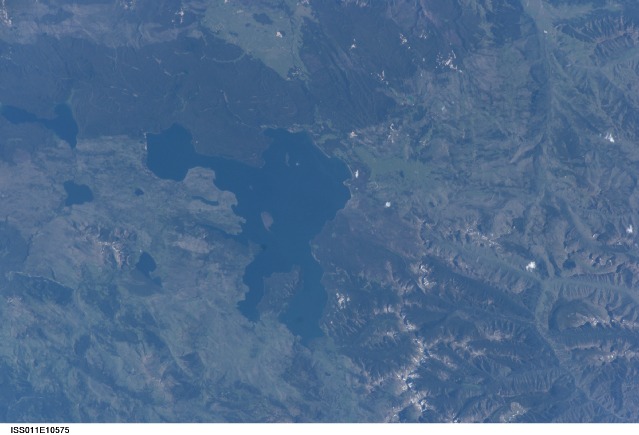
Features: YELLOWSTONE LAKE,SHOSHONE LAKE
Center Point Latitude: 44.5 Center Point Longitude: -110.5 (Negative numbers indicate south for latitude and west for longitude)
Stereo: (Yes indicates there is an adjacent picture of the same area)
ONC Map ID: JNC Map ID:
Camera
Camera Tilt: 42Camera Focal Length: 180mm
Camera: E4: Kodak DCS760C Electronic Still Camera
Film: 3060E : 3060 x 2036 pixel CCD, RGBG array.
Quality
Film Exposure:Percentage of Cloud Cover: 10 (0-10)
Nadir
Date: 20050715 (YYYYMMDD)GMT Time: 231325 (HHMMSS)Nadir Point Latitude: 47.3, Longitude: -110.3 (Negative numbers indicate south for latitude and west for longitude)
Nadir to Photo Center Direction: South
Sun Azimuth: 261 (Clockwise angle in degrees from north to the sun measured at the nadir point)
Spacecraft Altitude: 187 nautical miles (346 km)
Sun Elevation Angle: 38 (Angle in degrees between the horizon and the sun, measured at the nadir point)
Orbit Number: 2021
Captions
Yellowstone Lake, WyomingHuge volcanic eruptions that occurred over the past 2 million years formed Yellowstone National Park’s striking landscape. Two eruptions from 1.2 million and 600,000 years ago ejected more than 1,000 cubic kilometers (240 cubic miles) of material each, making them among the largest volcanic eruptions known in the Earth’s geologic record. At the same time, the emptying of the magma chambers beneath Yellowstone created large surface depressions called calderas. The youngest caldera measures nearly 80 kilometers (50 miles) long by 50 kilometers (31 miles) wide. Thought by most geologists to be the current location of a “hot spot” of upwelling, hot material from Earth’s mantle, the continuing activity of the region is demonstrated by its geysers, hot springs, and boiling mud pots.
This astronaut photograph is centered on Yellowstone Lake, a popular camping and fishing location within the National Park. The lake basin includes part of the youngest caldera and has an area of 352 square kilometers (136 square miles). Due to the rise and fall of resurgent domes (the locations of volcanic vents) located nearby, the lake basin is now tilted southwards, causing beaches to grow along the northern shore and flooding to occur in the southern arms of the lake. The West Thumb of Yellowstone Lake was formed by an eruption that occurred approximately 150,000 years ago. The resulting relatively small caldera was subsequently filled with water and joined with the larger lake to the east. Numerous geothermal features such as geysers and hot springs are located in the West Thumb area— this is thought to be due to a relatively shallow, local magma source.
A more recent change to Yellowstone’s geography is the area covered by large fire scars— cleared areas burned during the vast 1988 forest fires. The scars are still highly visible 17 years later because the light-colored cleared regions contrast with the surrounding forest.
Download Packaged File.
This option downloads the following items, packaged into a single file, if they are available:
- Browse image
- Cataloged information with captions
- Camera file
- Sound file
Server: 2 |
This service is provided by the International Space Station program. |
Recommended Citation: |
||

