| Home >> | Advanced Search >> |
 |
|
Astronaut Photography of Earth - Display Record
ISS017-E-10310
Low-resolution Browse Image
(Most browse images are not color adjusted.)Images
Conditions for Use of Images >>Image Transformation Tutorial >> Saving, Color Adjusting, and Printing Images >>
Images to View on Your Computer Now
| File Name | File Size (bytes) | Width | Height | Annotated | Cropped | Purpose | Comments | |
|---|---|---|---|---|---|---|---|---|
| View | ISS017-E-10310.JPG | 86776 | 640 | 437 | No | No | ||
| View | ISS017-E-10310.JPG | 363061 | 540 | 614 | Yes | Yes | NASA's Earth Observatory web site |
Large Images to Request for Downloading
| File Name | File Size (bytes) | Width | Height | Annotated | Cropped | Purpose | Comments | |
|---|---|---|---|---|---|---|---|---|
| Request | ISS017-E-10310.JPG | 773825 | 3072 | 2098 | No | No | ||
| Request | ISS017-E-10310.JPG | 982774 | 1000 | 1137 | No | Yes | NASA's Earth Observatory web site |
Download a Keyhole Markup Language (KML) file for use in Google Earth.
Electronic Image Data
Camera Files >> No sound file available.Identification
Mission: ISS017 Roll: E Frame: 10310 Mission ID on the Film or image: ISS017Country or Geographic Name: USA-CALIFORNIA
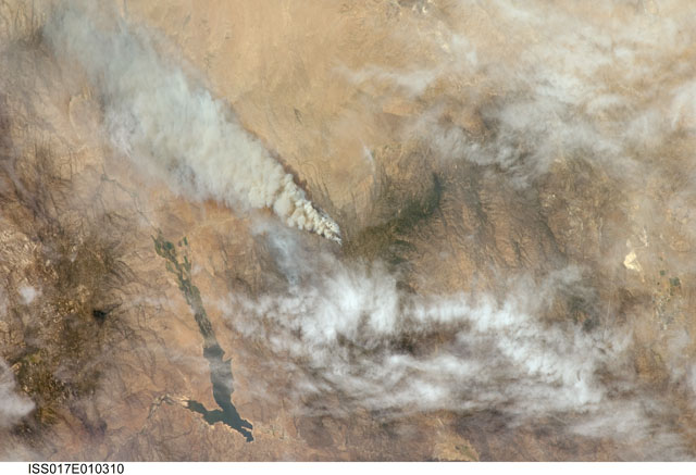
Features: PIUTE FIRE, HEALD PK., RES.
Center Point Latitude: 35.5 Center Point Longitude: -118.5 (Negative numbers indicate south for latitude and west for longitude)
Stereo: (Yes indicates there is an adjacent picture of the same area)
ONC Map ID: JNC Map ID:
Camera
Camera Tilt: 45Camera Focal Length: 180mm
Camera: N2: Nikon D2Xs
Film: 4288E : 4288 x 2848 pixel CMOS sensor, RGBG imager color filter.
Quality
Film Exposure:Percentage of Cloud Cover: 25 (11-25)
Nadir
Date: 20080704 (YYYYMMDD)GMT Time: 180421 (HHMMSS)Nadir Point Latitude: 32.4, Longitude: -118.1 (Negative numbers indicate south for latitude and west for longitude)
Nadir to Photo Center Direction: North
Sun Azimuth: 104 (Clockwise angle in degrees from north to the sun measured at the nadir point)
Spacecraft Altitude: 187 nautical miles (346 km)
Sun Elevation Angle: 63 (Angle in degrees between the horizon and the sun, measured at the nadir point)
Orbit Number: 3129
Captions
Piute Fire, CaliforniaThe Piute Fire, burning south of Lake Isabella in the Sequoia National Forest in the southern Sierra Nevada Mountains, was one of the more than 300 wildfires burning across the state of California in early July 2008. The fire started June 28 just north of Twin Oaks, California, and had burned nearly 34,000 acres as of July 10, according to reports from the National Interagency Fire Center. They estimated the fire might not be brought under control for another 2 weeks.
Download Packaged File.
This option downloads the following items, packaged into a single file, if they are available:
- Browse image
- Cataloged information with captions
- Camera file
- Sound file
Server: 2 |
This service is provided by the International Space Station program. |
Recommended Citation: |
||

