
| ||
Solimões-Negro River Confluence at Manaus, Amazonia
| ||||
|
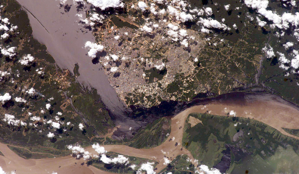
The largest river on the planet, the Amazon, forms from the confluence of the Solimões (the upper Amazon River) and the Negro at the Brazilian city of Manaus in central Amazonas. At the river conjunction, the muddy, tan-colored waters of the Solimões meet the “black” water of the Negro River. The unique mixing zone where the waters meet extends downstream through the rainforest for hundreds of kilometers, and is a famous attraction for tourists from all over the world. The tourism contributes to substantial growth in the city of Manaus. Twenty years ago the large park near the city center (center) lay on the eastern outskirts of Manaus. It is the vast quantity of sediment eroded from the Andes Mountains that gives the Solimões its tan color. By comparison, water in the Negro derives from the low jungles where reduced physical erosion of rock precludes mud entering the river. In place of sediment, organic matter from the forest floor stains the river the color of black tea. The Solimões provides nutrient-rich mud to lakes on the floodplain (lower right). The ecology of muddy lakes differs correspondingly from that of nutrient-poor, blackwater rivers and lakes. Solimões water can be seen leaking into the Negro west of the main meeting zone (lower left). The Solimões is much shallower than the Negro because it has filled its valley and bed with great quantities of sediment since the valleys were excavated. Indeed, widths of the rivers differ for this reason (the Negro River is almost 20 km wide in the top left corner). Astronaut photograph ISS009-E-15488 was acquired July 7, 2004, with a Kodak 760C digital camera with an 180-mm lens, and is provided by the ISS Crew Earth Observations experiment and the Image Science & Analysis Group, Johnson Space Center. The International Space Station Program supports the laboratory to help astronauts take pictures of Earth that will be of the greatest value to scientists and the public, and to make those images freely available on the Internet. Additional images taken by astronauts and cosmonauts can be viewed at the NASA/JSC Gateway to Astronaut Photography of Earth. Recommend this Image to a Friend Back to: Newsroom Also see |
View Images Index
| |||
| Subscribe to the
Earth Observatory About the Earth Observatory Please send comments or questions to: eobmail@eodomo.gsfc.nasa.gov Responsible NASA official: Yoram Kaufman NASA/GSFC Security and Privacy Statement |
 Click here to view full
image
Click here to view full
image


