| Home >> | Advanced Search >> |
 |
|
Astronaut Photography of Earth - Display Record
ISS005-E-9293

Low-resolution Browse Image
(Most browse images are not color adjusted.)Images
Conditions for Use of Images >>Image Transformation Tutorial >> Saving, Color Adjusting, and Printing Images >>
Images to View on Your Computer Now
| File Name | File Size (bytes) | Width | Height | Annotated | Cropped | Purpose | Comments | |
|---|---|---|---|---|---|---|---|---|
| View | ISS005-E-9293.JPG | 81284 | 639 | 435 | No | No | ||
| View | ISS005-E-9293.JPG | 121220 | 540 | 724 | Yes | Yes | NASA's Earth Observatory web site | |
| View | ISS005-E-9293.JPG | 555537 | 540 | 724 | No | Yes | NASA's Earth Observatory web site | |
| View | ISS005-E-9293.JPG | 1679802 | 1000 | 1341 | No | Yes | NASA's Earth Observatory web site |
Large Images to Request for Downloading
| File Name | File Size (bytes) | Width | Height | Annotated | Cropped | Purpose | Comments | |
|---|---|---|---|---|---|---|---|---|
| Request | ISS005-E-9293.JPG | 2141553 | 3032 | 2064 | No | No |
Download a Keyhole Markup Language (KML) file for use in Google Earth.
Electronic Image Data
Camera Files >> No sound file available.Identification
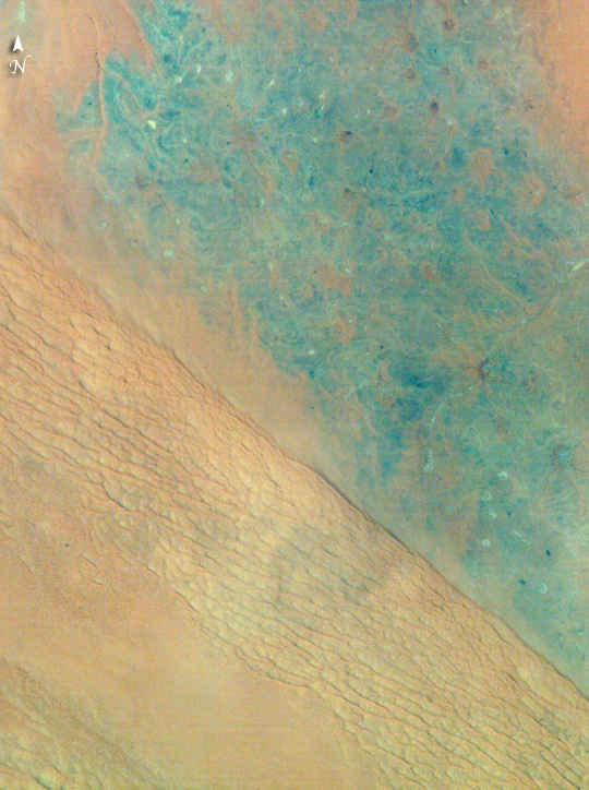
Mission: ISS005 Roll: E Frame: 9293 Mission ID on the Film or image: ISS005Country or Geographic Name: SAUDI ARABIA
Features: SAND DUNES, DEPRESSIONS
Center Point Latitude: 27.1 Center Point Longitude: 45.1 (Negative numbers indicate south for latitude and west for longitude)
Stereo: (Yes indicates there is an adjacent picture of the same area)
ONC Map ID: JNC Map ID:
Camera
Camera Tilt: 46Camera Focal Length: 800mm
Camera: E4: Kodak DCS760C Electronic Still Camera
Film: 3060E : 3060 x 2036 pixel CCD, RGBG array.
Quality
Film Exposure:Percentage of Cloud Cover: 10 (0-10)
Nadir
Date: 20020810 (YYYYMMDD)GMT Time: 103855 (HHMMSS)Nadir Point Latitude: 29.1, Longitude: 48.1 (Negative numbers indicate south for latitude and west for longitude)
Nadir to Photo Center Direction: Southwest
Sun Azimuth: 247 (Clockwise angle in degrees from north to the sun measured at the nadir point)
Spacecraft Altitude: 211 nautical miles (391 km)
Sun Elevation Angle: 62 (Angle in degrees between the horizon and the sun, measured at the nadir point)
Orbit Number: 1253
Captions
Ad Dahna Sand Cordon, Saudi Arabia:Driven by northwesterly winds, sands from northwest Saudi Arabia have accumulated in the center of the country as great rivers of dunes (cordons) that extend for hundreds of kilometers. About 320 kilometers northwest of Riyadh, the steep, almost cliff-like margin of the Ad Dahna cordon casts a shadow (right center; diagonally across the scene). Two types of dune surface appear: the tracery of numerous linear dunes (center) and a featureless sand sheet (lower left). Dark, older rocks (30-65 million years old—top right) underlie the sand sea and crop out northeast of the cordon. Convergent dry river beds appear top right.
Astronauts have obtained thousands of detailed images of the world’s remote deserts, helping scientists better understand local geomorphological features in a regional context.
Download Packaged File.
This option downloads the following items, packaged into a single file, if they are available:
- Browse image
- Cataloged information with captions
- Camera file
- Sound file
Server: 2 |
This service is provided by the International Space Station program. |
Recommended Citation: |
||

