| Home >> | Advanced Search >> |
 |
|
Astronaut Photography of Earth - Display Record
ISS001-E-6691

Low-resolution Browse Image
(Most browse images are not color adjusted.)Images
Conditions for Use of Images >>Image Transformation Tutorial >> Saving, Color Adjusting, and Printing Images >>
Images to View on Your Computer Now
| File Name | File Size (bytes) | Width | Height | Annotated | Cropped | Purpose | Comments | |
|---|---|---|---|---|---|---|---|---|
| View | ISS001-E-6691.JPG | 68694 | 540 | 359 | Yes | No | NASA's Earth Observatory web site | |
| View | ISS001-E-6691_2.JPG | 81935 | 400 | 266 | Yes | No | Photographic Highlights | |
| View | ISS001-E-6691.JPG | 138169 | 640 | 425 | No | No | ||
| View | ISS001-E-6691.JPG | 284780 | 1200 | 798 | No | No | Cities collection | |
| View | ISS001-E-6691.JPG | 6360092 | 3060 | 2036 | No | No | Cities collection | |
| View | ISS001-E-6691.JPG | 6360092 | 3060 | 2036 | NASA's Earth Observatory web site |
Large Images to Request for Downloading
| File Name | File Size (bytes) | Width | Height | Annotated | Cropped | Purpose | Comments | |
|---|---|---|---|---|---|---|---|---|
| Request | ISS001-E-6691_2.JPG | 4214754 | 3060 | 2036 | No | No | ||
| Request | ISS001-E-6691.JPG | 6360092 | 3060 | 2036 | No | No | NASA's Earth Observatory web site |
Download a Keyhole Markup Language (KML) file for use in Google Earth.
Electronic Image Data
Camera Files >> No sound file available.Identification
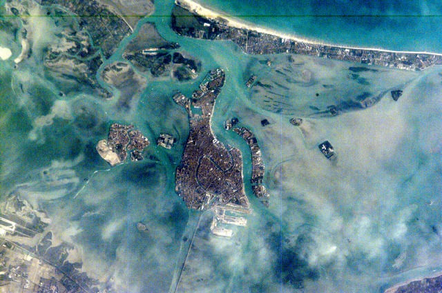
Mission: ISS001 Roll: E Frame: 6691 Mission ID on the Film or image: ISS01Country or Geographic Name: ITALY
Features: VENICE
Center Point Latitude: 45.5 Center Point Longitude: 12.5 (Negative numbers indicate south for latitude and west for longitude)
Stereo: (Yes indicates there is an adjacent picture of the same area)
ONC Map ID: JNC Map ID:
Camera
Camera Tilt: 9Camera Focal Length: 800mm
Camera: E2: Kodak DCS460 Electronic Still Camera
Film: 3060E : 3060 x 2036 pixel CCD, RGBG array.
Quality
Film Exposure:Percentage of Cloud Cover: 10 (0-10)
Nadir
Date: 20010221 (YYYYMMDD)GMT Time: 132619 (HHMMSS)Nadir Point Latitude: 45.4, Longitude: 12.0 (Negative numbers indicate south for latitude and west for longitude)
Nadir to Photo Center Direction: East
Sun Azimuth: 214 (Clockwise angle in degrees from north to the sun measured at the nadir point)
Spacecraft Altitude: 201 nautical miles (372 km)
Sun Elevation Angle: 28 (Angle in degrees between the horizon and the sun, measured at the nadir point)
Orbit Number: 903
Captions
The compact Italian city of Venice with its renowned canals is situated on a small, fish-shaped island in the Laguna Veneta at the northwest corner of the Adriatic Sea. In this photo taken from the International Space Station by the Expedition 1 Crew on February 21, 2001, one can see part of the causeway connecting the city to the mainland. The sinuous Canal Grande bisecting the city is easily visible in this scene as is the larger Canal Guidecca to the west, which leads to the port facilities on the northwestern end of the island. For centuries, the low-lying city has successfully coped with the three-foot tidal range experienced at this end of the Adriatic Sea, and the series of barrier islands has offered some protection from storm waves. However, a combination of both regional land subsidence and recent slight rises in sea level pose a significant threat this historic city and its priceless art treasures.Download Packaged File.
This option downloads the following items, packaged into a single file, if they are available:
- Browse image
- Cataloged information with captions
- Camera file
- Sound file
Server: 2 |
This service is provided by the International Space Station program. |
Recommended Citation: |
||

