| Home >> | Advanced Search >> |
 |
|
Astronaut Photography of Earth - Display Record
ISS012-E-6456

Low-resolution Browse Image
(Most browse images are not color adjusted.)Images
Conditions for Use of Images >>Image Transformation Tutorial >> Saving, Color Adjusting, and Printing Images >>
Images to View on Your Computer Now
| File Name | File Size (bytes) | Width | Height | Annotated | Cropped | Purpose | Comments | |
|---|---|---|---|---|---|---|---|---|
| View | ISS012-E-6456.JPG | 78480 | 639 | 435 | No | No | ||
| View | ISS012-E-6456.JPG | 181110 | 540 | 357 | Yes | Yes | NASA's Earth Observatory web site |
Large Images to Request for Downloading
| File Name | File Size (bytes) | Width | Height | Annotated | Cropped | Purpose | Comments | |
|---|---|---|---|---|---|---|---|---|
| Request | ISS012-E-6456.JPG | 508546 | 1000 | 661 | No | Yes | NASA's Earth Observatory web site | |
| Request | ISS012-E-6456.JPG | 717574 | 3032 | 2008 | No | No | Not enhanced | Converted to JPEG from a raw image |
Download a Keyhole Markup Language (KML) file for use in Google Earth.
Electronic Image Data
Camera Files >> No sound file available.Identification
Mission: ISS012 Roll: E Frame: 6456 Mission ID on the Film or image: ISS012Country or Geographic Name: BOLIVIA
Features: SALAR DE UYUNI,TAHUA
Center Point Latitude: -20.0 Center Point Longitude: -67.5 (Negative numbers indicate south for latitude and west for longitude)
Stereo: (Yes indicates there is an adjacent picture of the same area)
ONC Map ID: JNC Map ID:
Camera
Camera Tilt: 48Camera Focal Length: 180mm
Camera: E4: Kodak DCS760C Electronic Still Camera
Film: 3060E : 3060 x 2036 pixel CCD, RGBG array.
Quality
Film Exposure:Percentage of Cloud Cover: 10 (0-10)
Nadir
Date: 20051103 (YYYYMMDD)GMT Time: 181305 (HHMMSS)Nadir Point Latitude: -22.6, Longitude: -69.8 (Negative numbers indicate south for latitude and west for longitude)
Nadir to Photo Center Direction: Northeast
Sun Azimuth: 281 (Clockwise angle in degrees from north to the sun measured at the nadir point)
Spacecraft Altitude: 189 nautical miles (350 km)
Sun Elevation Angle: 63 (Angle in degrees between the horizon and the sun, measured at the nadir point)
Orbit Number: 3764
Captions
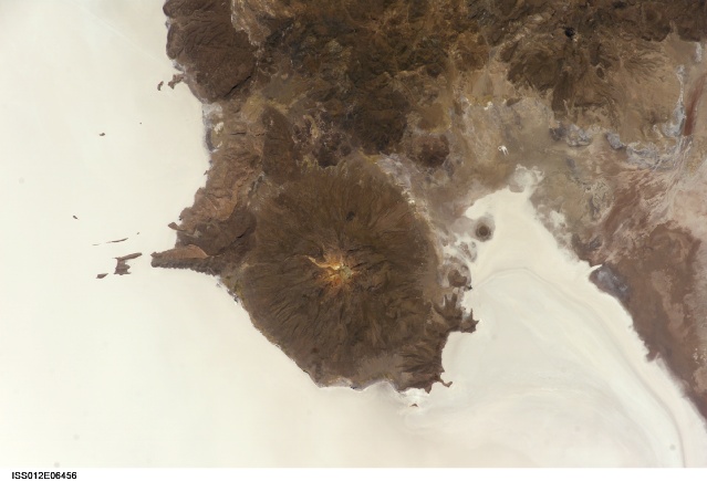
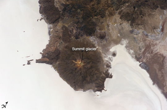
Salar de Uyuni, BoliviaThe largest salar (salt flat) in the world, Salar de Uyuni, is located within the Altiplano of Bolivia in South America. The Altiplano is a high plateau formed during uplift of the Andes Mountains. The plateau harbors fresh and saltwater lakes, together with salars, that are surrounded by mountains with no drainage outlets—all at elevations greater than 3,659 meters (12,000 feet) above mean sea level. The Salar de Uyuni covers approximately 8,000 square kilometers (3,100 square miles), and it is a major transport route across the Bolivian Altiplano due to its flatness.
This astronaut photograph features the northern end of the salar and the dormant volcano Mount Tunupa (image center). This mountain is high enough to support a summit glacier, and enough rain falls on the windward slopes to provide water for small communities along the base. The dark volcanic rocks comprising Mt. Tunupa are in sharp contrast with the white, mineral-crusted surface of the salar. The major minerals are halite—common table salt—and gypsum—a common component of drywall.
Relict shorelines visible in the surface salt deposits (lower right of the image) attest to the occasional presence of small amounts of water in the salar. Sediments in the salar basin record fluctuations in water levels that occurred as the lake that once occupied the salar evaporated. These sediments provide a valuable paleoclimate record for the region. The dynamic geological history of the Altiplano is recorded in isolated “islands” within the salt flat (image left); these islands are typically built from fossil coral reefs covered by Andean volcanic rocks.
Download Packaged File.
This option downloads the following items, packaged into a single file, if they are available:
- Browse image
- Cataloged information with captions
- Camera file
- Sound file
Server: 2 |
This service is provided by the International Space Station program. |
Recommended Citation: |
||

