| Home >> | Advanced Search >> |
 |
|
Astronaut Photography of Earth - Display Record
ISS016-E-22772
Low-resolution Browse Image
(Most browse images are not color adjusted.)Images
Conditions for Use of Images >>Image Transformation Tutorial >> Saving, Color Adjusting, and Printing Images >>
Images to View on Your Computer Now
| File Name | File Size (bytes) | Width | Height | Annotated | Cropped | Purpose | Comments | |
|---|---|---|---|---|---|---|---|---|
| View | ISS016-E-22772.JPG | 112873 | 639 | 435 | No | No | ||
| View | ISS016-E-22772.JPG | 308852 | 540 | 356 | Yes | Yes | NASA's Earth Observatory web site |
Large Images to Request for Downloading
| File Name | File Size (bytes) | Width | Height | Annotated | Cropped | Purpose | Comments | |
|---|---|---|---|---|---|---|---|---|
| Request | ISS016-E-22772.JPG | 866421 | 1000 | 659 | No | Yes | NASA's Earth Observatory web site | |
| Request | ISS016-E-22772.JPG | 1573028 | 3032 | 2064 | No | No |
Download a Keyhole Markup Language (KML) file for use in Google Earth.
Electronic Image Data
Camera Files >> No sound file available.Identification
Mission: ISS016 Roll: E Frame: 22772 Mission ID on the Film or image: ISS016Country or Geographic Name: AUSTRALIA-WA
Features: PERTH METRO AREA,APPLECROSS
Center Point Latitude: -31.9 Center Point Longitude: 115.8 (Negative numbers indicate south for latitude and west for longitude)
Stereo: (Yes indicates there is an adjacent picture of the same area)
ONC Map ID: JNC Map ID:
Camera
Camera Tilt: 23Camera Focal Length: 800mm
Camera: E4: Kodak DCS760C Electronic Still Camera
Film: 3060E : 3060 x 2036 pixel CCD, RGBG array.
Quality
Film Exposure:Percentage of Cloud Cover: 10 (0-10)
Nadir
Date: 20080111 (YYYYMMDD)GMT Time: 062104 (HHMMSS)Nadir Point Latitude: -31.7, Longitude: 114.5 (Negative numbers indicate south for latitude and west for longitude)
Nadir to Photo Center Direction: East
Sun Azimuth: 284 (Clockwise angle in degrees from north to the sun measured at the nadir point)
Spacecraft Altitude: 183 nautical miles (339 km)
Sun Elevation Angle: 63 (Angle in degrees between the horizon and the sun, measured at the nadir point)
Orbit Number: 360
Captions
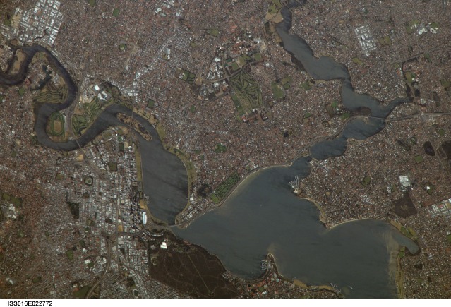
Perth, AustraliaPerth is the capital of the state of Western Australia, and it is the largest city of the southwestern part of the continent, with an estimated population of over 1.5 million (as of December 2006). The downtown area of Perth and the surrounding suburbs are located on flood plain deposits of the Swan and Canning Rivers, which flow through the center of the metropolitan area. Perth enjoys a Mediterranean climate, where the summers are hot and dry, and winters are cool and moist. Wildfires can develop during the summer months; several large fires threatened the eastern portion of the metropolitan area in 2005.
This astronaut photograph captures variations in urban land cover around Perth. The downtown center of the city (image left) is characterized by large buildings (such as skyscrapers) with white, reflective rooftops. Suburbs to the south (across the Swan River) are characterized by higher density of small buildings with predominantly reddish-purple roofs. Several areas of green vegetation are visible in the image. Parks and golf courses comprised mainly of grass present an even, green coloration, while the dense tree canopy of Kings Park appears dark green. Variations in the color of the Swan and Canning Rivers is due to sunglint, or light reflected off the water surface directly back to the observer (in this case, an astronaut about the International Space Station) like a mirror.
Download Packaged File.
This option downloads the following items, packaged into a single file, if they are available:
- Browse image
- Cataloged information with captions
- Camera file
- Sound file
Server: 2 |
This service is provided by the International Space Station program. |
Recommended Citation: |
||

