| Home >> | Advanced Search >> |
 |
|
Astronaut Photography of Earth - Display Record
ISS007-E-16813

Low-resolution Browse Image
(Most browse images are not color adjusted.)Images
Conditions for Use of Images >>Image Transformation Tutorial >> Saving, Color Adjusting, and Printing Images >>
Images to View on Your Computer Now
| File Name | File Size (bytes) | Width | Height | Annotated | Cropped | Purpose | Comments | |
|---|---|---|---|---|---|---|---|---|
| View | ISS007-E-16813.JPG | 81640 | 540 | 405 | Yes | Yes | NASA's Earth Observatory web site | |
| View | ISS007-E-16813.JPG | 81640 | 540 | 405 | Yes | Yes | NASA's Earth Observatory web site | |
| View | ISS007-E-16813.JPG | 84666 | 540 | 450 | Photographic Highlights | (resized 540 px images) | ||
| View | ISS007-E-16813.JPG | 90058 | 639 | 435 | No | No | ||
| View | ISS007-E-16813_2.JPG | 242347 | 922 | 768 | Photographic Highlights | (actual files used) | ||
| View | ISS007-E-16813.JPG | 1092799 | 1000 | 830 | No | Yes | NASA's Earth Observatory web site | Color adjusted |
Large Images to Request for Downloading
| File Name | File Size (bytes) | Width | Height | Annotated | Cropped | Purpose | Comments | |
|---|---|---|---|---|---|---|---|---|
| Request | ISS007-E-16813.JPG | 1186731 | 3032 | 2064 | No | No | ||
| Request | ISS007-E-16813.JPG | 3894691 | 3032 | 2064 | No | No | NASA's Earth Observatory web site | color corrected |
| Request | ISS007-E-16813_2.JPG | 5332504 | 6144 | 4068 | No | No | Presentation | Earth Sciences Results Briefing/Ed Lu |
Download a Keyhole Markup Language (KML) file for use in Google Earth.
Electronic Image Data
Camera Files >> No sound file available.Identification
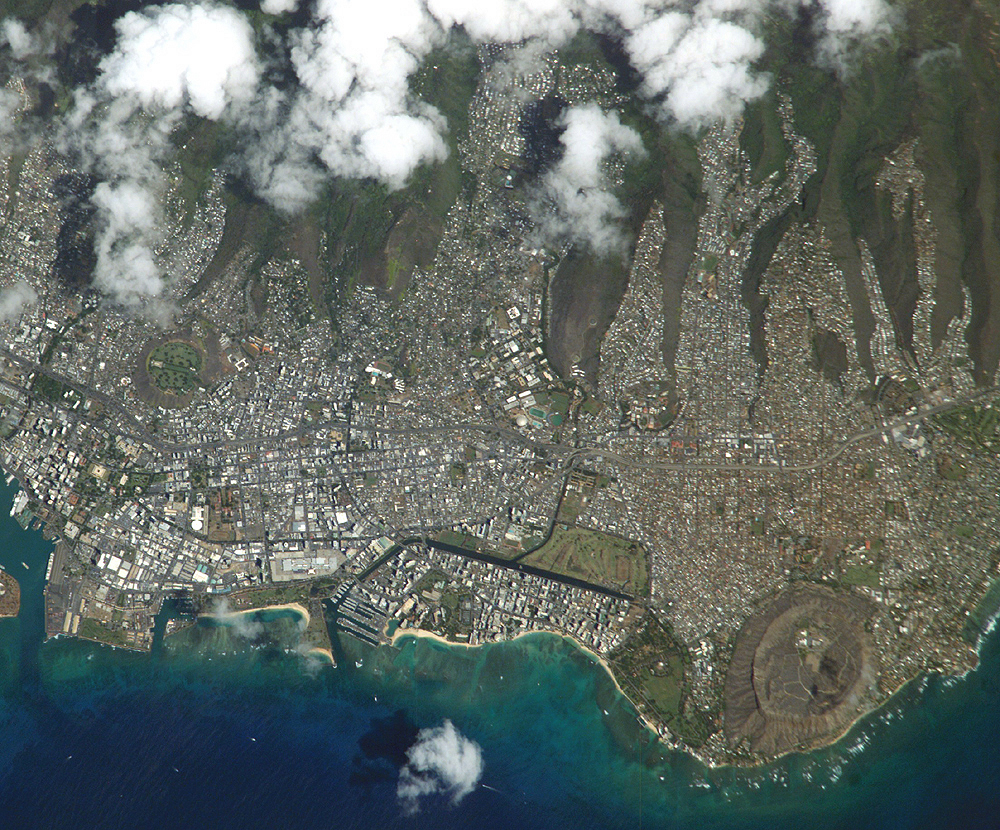
Mission: ISS007 Roll: E Frame: 16813 Mission ID on the Film or image: ISS007Country or Geographic Name: USA-HAWAII
Features: OAHU, HONOLULU, DIAMOND HEAD
Center Point Latitude: 21.5 Center Point Longitude: -158.0 (Negative numbers indicate south for latitude and west for longitude)
Stereo: (Yes indicates there is an adjacent picture of the same area)
ONC Map ID: JNC Map ID:
Camera
Camera Tilt: 32Camera Focal Length: 800mm
Camera: E4: Kodak DCS760C Electronic Still Camera
Film: 3060E : 3060 x 2036 pixel CCD, RGBG array.
Quality
Film Exposure:Percentage of Cloud Cover: 25 (11-25)
Nadir
Date: 20031008 (YYYYMMDD)GMT Time: 214155 (HHMMSS)Nadir Point Latitude: 19.7, Longitude: -159.1 (Negative numbers indicate south for latitude and west for longitude)
Nadir to Photo Center Direction: Northeast
Sun Azimuth: 157 (Clockwise angle in degrees from north to the sun measured at the nadir point)
Spacecraft Altitude: 203 nautical miles (376 km)
Sun Elevation Angle: 62 (Angle in degrees between the horizon and the sun, measured at the nadir point)
Orbit Number: 3877
Captions
Honolulu: The Expedition 7 crew on the International Space Station is set to come home to Earth in about a week. Crew member Ed Lu considers Honolulu to be his hometown, and the view from a recent overpass clearly inspired him to photograph the city.Honolulu is striking for the way it is bound by surrounding geography. Built-up fingers of the city extend northeast onto the steep volcanic slopes and surround the volcanic craters of Punchbowl and Diamond Head, leaving undeveloped only parklands and the steepest ridges. They are both tuff cones that formed as magma from the erupting volcano came in contact with ground water at a time when sea levels were higher than they are now. As the water turned to steam, it caused an explosion that formed a hill of ash with a broad crater in the center.
In Hawaiian, Punchbowl Crater was known as Pu’owaina, or, “Hill of Sacrifice,” and was a site of royal burials. Punchbowl is also the site of the National Memorial Cemetery of the Pacific. The area includes over 38,000 graves of U.S. service men and women beginning with casualties of the attack on Pearl Harbor in 1941. Ellison Onizuka, one of the Space Shuttle Challenger crew killed in 1986, is also buried there.
Diamond Head was called Le’ahi in Hawaiian or “Brow of the yellowfin tuna (ahi)”. British sailors in the 1700s saw calcite crystals sparking on the crater and gave it its English name. One of the major “must see” tourist destinations on Oahu, Diamond Head is managed as a Hawaii State Monument, and plans are in place to reduce vehicle traffic and restore the natural vegetation.
Download Packaged File.
This option downloads the following items, packaged into a single file, if they are available:
- Browse image
- Cataloged information with captions
- Camera file
- Sound file
Server: 2 |
This service is provided by the International Space Station program. |
Recommended Citation: |
||

