| Home >> | Advanced Search >> |
 |
|
Astronaut Photography of Earth - Display Record
ISS017-E-13769

Low-resolution Browse Image
(Most browse images are not color adjusted.)Images
Conditions for Use of Images >>Image Transformation Tutorial >> Saving, Color Adjusting, and Printing Images >>
Images to View on Your Computer Now
| File Name | File Size (bytes) | Width | Height | Annotated | Cropped | Purpose | Comments | |
|---|---|---|---|---|---|---|---|---|
| View | ISS017-E-13769.JPG | 83222 | 640 | 437 | No | No | ||
| View | ISS017-E-13769.JPG | 297170 | 540 | 361 | Yes | Yes | NASA's Earth Observatory web site |
Large Images to Request for Downloading
| File Name | File Size (bytes) | Width | Height | Annotated | Cropped | Purpose | Comments | |
|---|---|---|---|---|---|---|---|---|
| Request | ISS017-E-13769.JPG | 848316 | 3072 | 2098 | No | No | ||
| Request | ISS017-E-13769.JPG | 922042 | 1000 | 668 | No | Yes | NASA's Earth Observatory web site |
Download a Keyhole Markup Language (KML) file for use in Google Earth.
Electronic Image Data
Camera Files >> No sound file available.Identification
Mission: ISS017 Roll: E Frame: 13769 Mission ID on the Film or image: ISS017Country or Geographic Name: TUNISIA
Features: TUNIS METRO AREA,LAKE OF TUNIS
Center Point Latitude: 36.9 Center Point Longitude: 10.2 (Negative numbers indicate south for latitude and west for longitude)
Stereo: (Yes indicates there is an adjacent picture of the same area)
ONC Map ID: JNC Map ID:
Camera
Camera Tilt: 23Camera Focal Length: 400mm
Camera: N2: Nikon D2Xs
Film: 4288E : 4288 x 2848 pixel CMOS sensor, RGBG imager color filter.
Quality
Film Exposure:Percentage of Cloud Cover: 10 (0-10)
Nadir
Date: 20080819 (YYYYMMDD)GMT Time: 143346 (HHMMSS)Nadir Point Latitude: 35.8, Longitude: 9.4 (Negative numbers indicate south for latitude and west for longitude)
Nadir to Photo Center Direction: Northeast
Sun Azimuth: 253 (Clockwise angle in degrees from north to the sun measured at the nadir point)
Spacecraft Altitude: 190 nautical miles (352 km)
Sun Elevation Angle: 42 (Angle in degrees between the horizon and the sun, measured at the nadir point)
Orbit Number: 3851
Captions
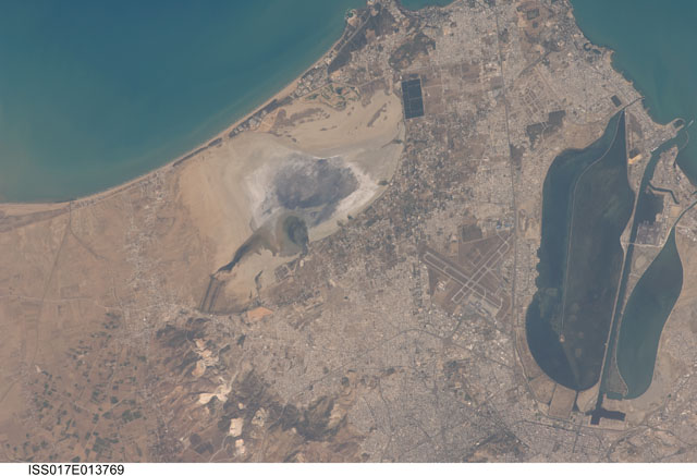
Tunis, TunisiaThe city of Tunis, capital of Tunisia, is located along the Mediterranean coast of northern Africa. Sharing much of its history with famous Carthage to the north, Tunis was also destroyed by the Roman Empire in approximately 146 BC. Tunis, however, was rebuilt by the Romans and became an important agricultural center. Modern Tunis serves as the administrative center for the whole of Tunisia, and as a commercial hub in the northern part of the country.
The urban area of Tunis is located on a flat coastal plain, and is distinguished in this astronaut photograph from the surrounding desert by the pattern of grey and tan buildings and the dark street grid. The city is bordered by an evaporating saline lake to the northeast known as Sebkhet Arina (upper left). Evaporite minerals such as halite (sodium chloride, or table salt) and gypsum produce the white deposits. They surround the darker lake center, where there is more moisture. The western urban-rural fringe is defined by a range of low hills (lower left). On the western side of these hills, dark green agricultural fields are visible.
To the southeast of the city is Lake Tunis, a lagoon that people have significantly altered from its natural state. For example, it is completely closed off from the Mediterranean Sea except for two channels, and has been since Roman times. The general lack of water circulation and input of nutrients from wastewater have altered the ecosystem, allowing reef-forming marine worms to become established; the reefs further stifle water circulation. The wastewater also causes eutrophication (overly fertile waters that trigger algae overgrowth) and occasional fish kills.
Download Packaged File.
This option downloads the following items, packaged into a single file, if they are available:
- Browse image
- Cataloged information with captions
- Camera file
- Sound file
Server: 2 |
This service is provided by the International Space Station program. |
Recommended Citation: |
||

