| Home >> | Advanced Search >> |
 |
|
Astronaut Photography of Earth - Display Record
ISS007-E-13327

Low-resolution Browse Image
(Most browse images are not color adjusted.)Images
Conditions for Use of Images >>Image Transformation Tutorial >> Saving, Color Adjusting, and Printing Images >>
Images to View on Your Computer Now
| File Name | File Size (bytes) | Width | Height | Annotated | Cropped | Purpose | Comments | |
|---|---|---|---|---|---|---|---|---|
| View | ISS007-E-13327.JPG | 45437 | 540 | 405 | Yes | NASA's Earth Observatory web site | ||
| View | ISS007-E-13327.JPG | 45437 | 540 | 405 | Yes | Yes | NASA's Earth Observatory web site | |
| View | ISS007-E-13327.JPG | 69951 | 639 | 435 | No | No | ||
| View | ISS007-E-13327.JPG | 74710 | 540 | 448 | Photographic Highlights | (resized 540 px images) | ||
| View | ISS007-E-13327_2.JPG | 214473 | 925 | 768 | Photographic Highlights | (actual files used) | ||
| View | ISS007-E-13327.JPG | 324035 | 1000 | 828 | No | Yes | NASA's Earth Observatory web site |
Large Images to Request for Downloading
| File Name | File Size (bytes) | Width | Height | Annotated | Cropped | Purpose | Comments | |
|---|---|---|---|---|---|---|---|---|
| Request | ISS007-E-13327.JPG | 826999 | 3032 | 2064 | No | No | ||
| Request | ISS007-E-13327_2.JPG | 3728984 | 6144 | 4068 | No | No | Presentation | Earth Sciences Results Briefing/Ed Lu |
Download a Keyhole Markup Language (KML) file for use in Google Earth.
Electronic Image Data
Camera Files >> No sound file available.Identification
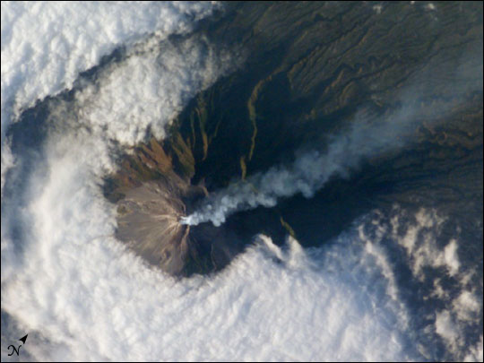
Mission: ISS007 Roll: E Frame: 13327 Mission ID on the Film or image: ISS007Country or Geographic Name: INDONESIA-J
Features: MOUNT MERAPI, PLUME, AGRICULTURE
Center Point Latitude: -7.5 Center Point Longitude: 110.5 (Negative numbers indicate south for latitude and west for longitude)
Stereo: (Yes indicates there is an adjacent picture of the same area)
ONC Map ID: JNC Map ID:
Camera
Camera Tilt: 8Camera Focal Length: 400mm
Camera: E4: Kodak DCS760C Electronic Still Camera
Film: 3060E : 3060 x 2036 pixel CCD, RGBG array.
Quality
Film Exposure:Percentage of Cloud Cover: 50 (26-50)
Nadir
Date: 20030824 (YYYYMMDD)GMT Time: 091807 (HHMMSS)Nadir Point Latitude: -7.2, Longitude: 110.9 (Negative numbers indicate south for latitude and west for longitude)
Nadir to Photo Center Direction: Southwest
Sun Azimuth: 284 (Clockwise angle in degrees from north to the sun measured at the nadir point)
Spacecraft Altitude: 205 nautical miles (380 km)
Sun Elevation Angle: 18 (Angle in degrees between the horizon and the sun, measured at the nadir point)
Orbit Number: 3165
Captions
Merapi Volcano, Java: At 2,911 meters, the summit of Merapi Volcano and its vigorous steam plume rises above a bank of stratus clouds on its southern flank on August 24, 2003. One of Indonesia’s most active volcanoes, it has been almost continuously active for nearly ten years, including periodic pyroclastic flows (hot ash and rock debris) and avalanches. The volcano is located less than 25 miles north of the city of Yogykarta in central Java. More than 50,000 people live adjacent the treacherous southwestern slope, where volcanic material often sloughs from the unstable summit. Note the deep ravines on the eastern slopes providing rich soils and moisture to the agriculture below.Download Packaged File.
This option downloads the following items, packaged into a single file, if they are available:
- Browse image
- Cataloged information with captions
- Camera file
- Sound file
Server: 2 |
This service is provided by the International Space Station program. |
Recommended Citation: |
||

