| Home >> | Advanced Search >> |
 |
|
Astronaut Photography of Earth - Display Record
ISS010-E-12103
Low-resolution Browse Image
(Most browse images are not color adjusted.)Images
Conditions for Use of Images >>Image Transformation Tutorial >> Saving, Color Adjusting, and Printing Images >>
Images to View on Your Computer Now
| File Name | File Size (bytes) | Width | Height | Annotated | Cropped | Purpose | Comments | |
|---|---|---|---|---|---|---|---|---|
| View | ISS010-E-12103.JPG | 88306 | 639 | 437 | No | No | ||
| View | ISS010-E-12103.JPG | 296634 | 509 | 540 | Yes | Yes | Earth From Space collection | |
| View | ISS010-E-12103.JPG | 296634 | 509 | 540 | Yes | Yes | NASA's Earth Observatory web site | |
| View | ISS010-E-12103.JPG | 1102006 | 1000 | 943 | No | Yes | NASA's Earth Observatory web site |
Large Images to Request for Downloading
| File Name | File Size (bytes) | Width | Height | Annotated | Cropped | Purpose | Comments | |
|---|---|---|---|---|---|---|---|---|
| Request | ISS010-E-12103.JPG | 1030123 | 2000 | 1368 | No | No | ||
| Request | ISS010-E-12103.JPG | 1102006 | 1000 | 943 | No | Yes | Earth From Space collection |
Download a Keyhole Markup Language (KML) file for use in Google Earth.
Electronic Image Data
Camera Files >> No sound file available.Identification
Mission: ISS010 Roll: E Frame: 12103 Mission ID on the Film or image: ISS010Country or Geographic Name: SOUTH KOREA
Features: SEOUL AT NIGHT
Center Point Latitude: 37.5 Center Point Longitude: 127.0 (Negative numbers indicate south for latitude and west for longitude)
Stereo: (Yes indicates there is an adjacent picture of the same area)
ONC Map ID: JNC Map ID:
Camera
Camera Tilt: High ObliqueCamera Focal Length: 58mm
Camera: N1: Nikon D1
Film: 2000E : 2000 x 1312 pixel CCD, RGBG imager color filter.
Quality
Film Exposure:Percentage of Cloud Cover: 10 (0-10)
Nadir
Date: 20041225 (YYYYMMDD)GMT Time: 161628 (HHMMSS)Nadir Point Latitude: 48.2, Longitude: 151.3 (Negative numbers indicate south for latitude and west for longitude)
Nadir to Photo Center Direction: West
Sun Azimuth: 61 (Clockwise angle in degrees from north to the sun measured at the nadir point)
Spacecraft Altitude: 187 nautical miles (346 km)
Sun Elevation Angle: -53 (Angle in degrees between the horizon and the sun, measured at the nadir point)
Orbit Number: 2840
Captions
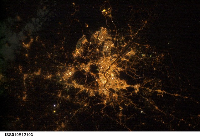
Seoul, South KoreaThe city of Seoul (originally known as Hanyang) has been the capitol of Korea for more than 600 years. It became the capitol of South Korea as part of that country’s independence in 1949. Despite this long history, Seoul is a thoroughly modern megacity that has a population of over 10 million people. As the dominant (or “primate”) city in South Korea, Seoul is a major force in regional politics, finance, culture, and education.
This astronaut photograph illustrates the Seoul urban area at night. Major roadways and river courses (such as the Han River) are clearly outlined by street lights, while the brightest lights indicate the downtown urban core (center of image) and large industrial complexes. One such complex is located at the far left of the image and occupies an island in the Yellow Sea. Very dark regions in the image are mountains or large bodies of water. Nighttime images have been used extensively in urban climate and urban growth research to map the extent of urban (bright) versus rural (dark) regions.
Download Packaged File.
This option downloads the following items, packaged into a single file, if they are available:
- Browse image
- Cataloged information with captions
- Camera file
- Sound file
Server: 2 |
This service is provided by the International Space Station program. |
Recommended Citation: |
||

