| Home >> | Advanced Search >> |
 |
|
Astronaut Photography of Earth - Display Record
ISS011-E-11543
Low-resolution Browse Image
(Most browse images are not color adjusted.)Images
Conditions for Use of Images >>Image Transformation Tutorial >> Saving, Color Adjusting, and Printing Images >>
Images to View on Your Computer Now
| File Name | File Size (bytes) | Width | Height | Annotated | Cropped | Purpose | Comments | |
|---|---|---|---|---|---|---|---|---|
| View | ISS011-E-11543.JPG | 77498 | 639 | 435 | No | No | ||
| View | ISS011-E-11543.JPG | 305583 | 540 | 357 | Yes | Yes | NASA's Earth Observatory web site |
Large Images to Request for Downloading
| File Name | File Size (bytes) | Width | Height | Annotated | Cropped | Purpose | Comments | |
|---|---|---|---|---|---|---|---|---|
| Request | ISS011-E-11543.JPG | 941231 | 1000 | 661 | No | Yes | NASA's Earth Observatory web site | |
| Request | ISS011-E-11543.JPG | 1203858 | 3032 | 2008 | No | No | Not enhanced | Converted to JPEG from a raw image |
Download a Keyhole Markup Language (KML) file for use in Google Earth.
Electronic Image Data
Camera Files >> No sound file available.Identification
Mission: ISS011 Roll: E Frame: 11543 Mission ID on the Film or image: ISS011Country or Geographic Name: USA-CALIFORNIA
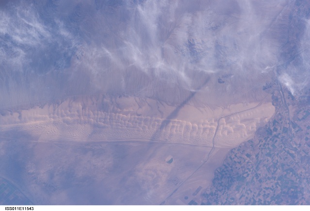
Features: ALGODONES DUNE FIELD,CUERVOS
Center Point Latitude: 33.0 Center Point Longitude: -115.0 (Negative numbers indicate south for latitude and west for longitude)
Stereo: (Yes indicates there is an adjacent picture of the same area)
ONC Map ID: JNC Map ID:
Camera
Camera Tilt: 19Camera Focal Length: 165mm
Camera: E4: Kodak DCS760C Electronic Still Camera
Film: 3060E : 3060 x 2036 pixel CCD, RGBG array.
Quality
Film Exposure:Percentage of Cloud Cover: 10 (0-10)
Nadir
Date: 20050803 (YYYYMMDD)GMT Time: 141148 (HHMMSS)Nadir Point Latitude: 34.1, Longitude: -114.8 (Negative numbers indicate south for latitude and west for longitude)
Nadir to Photo Center Direction: South
Sun Azimuth: 79 (Clockwise angle in degrees from north to the sun measured at the nadir point)
Spacecraft Altitude: 190 nautical miles (352 km)
Sun Elevation Angle: 15 (Angle in degrees between the horizon and the sun, measured at the nadir point)
Orbit Number: 2314
Captions
Algodones Dunefield, CaliforniaFans of the Star Wars series of films may recognize the Algodones Dunefield—also known as the Imperial Dunes—as portions of the imaginary planet of Tatooine. While not planetary in scale, this dunefield located at the junction of three states (Arizona and California in the United States; Baja California del Norte in Mexico) is a distinctive feature of North America. The field is approximately 72 kilometers long by 10 kilometers wide (45 miles by 6 miles) and extends along a northwest-southeast line that correlates to the prevailing northerly and westerly wind directions. The dunefield is a wilderness area, with the only human structure being the All American Canal that cuts across the southern portion from west to east (right side of view). A checkerboard pattern of farms in the Colorado River floodplain is visible on the Mexican side of the border (far right). Wisps of cloud obscure the Cargo Muchacho Mountains (top).
Distinctive dune forms visible in this astronaut photograph include transverse megadunes and linear dunes. The transverse dunes, appearing much like a large tank tread along the long axis of the dunefield, are the largest features. They were formed by strong and constant northwesterly winds. A fine pattern of smaller dunes has formed along the crests and windward (northwestern) sides of these large dunes and point to continuing sediment transport activity. Networks of small dunes along the western side of the dunefield suggest that wind direction here is more variable, and perhaps influenced by the large transverse dunes themselves. Long, linear dunes extending northwest-southeast are visible along the western edge of the dunefield.
The presence of vegetated drainage networks along the northeastern border of the dunefield and the relative lack of dunes themselves suggest that dunes are not migrating rapidly along this margin. The majority of dune migration today occurs at a rate of approximately 0.3 meters per year (1 foot per year) along the southeast margin of the dunefield.
Download Packaged File.
This option downloads the following items, packaged into a single file, if they are available:
- Browse image
- Cataloged information with captions
- Camera file
- Sound file
Server: 2 |
This service is provided by the International Space Station program. |
Recommended Citation: |
||

