|
Higher resolution 1000 pixel-wide image
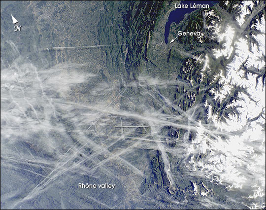
This digital photograph taken through the windows of the International Space
Station on May 15, 2002, shows condensation trails over the Rhône Valley in the
region west of Lyon. Condensation trails—or contrails—are straight lines of ice
crystals that form in the wake of jet liners where air temperatures at altitude
are lower than about –40°C.
Newer contrails are thin whereas older
trails have widened with time as a result of light winds. Because of this
tendency for thin contrails to cover greater areas with time, it is estimated
that these “artificial clouds” cover 0.1% of the planet’s surface. Percentages
are far higher in some places such as southern California, the Ohio River
Valley and parts of Europe, as illustrated here.
The climatic impact of
such clouds is poorly understood. In an unprecedented experiment following the
September 11 grounding of all aircraft in the United States, researchers
reported in the August 8 issue of Nature that temperatures in areas usually
affected by contrail blankets fluctuated higher and lower during the
contrail-free period. Despite this dramatic conclusion, it is nevertheless too early to
know whether contrails produce a net warming or cooling of the atmosphere.
Whereas cirrus clouds seem to have a net warming effect, contrails are denser
and thus may produce the opposite effect.
References:
Travis, D. J.,
Carleton, A. M. and R. G. Lauritsen. 2002. Contrails reduce daily temperature
range. Nature 418:601.
9/11 study: Air traffic affects climate (CNN)
References:
Travis, D. J., Carleton, A. M. and R. G.
Lauritsen. 2002. Contrails reduce daily temperature range. Nature
418:601.
9/11 study: Air traffic affects climate (CNN)
Astronaut photograph ISS004-E-11807 was provided by the Earth Sciences and
Image Analysis Laboratory at Johnson Space Center. Additional images taken
by astronauts and cosmonauts can be viewed at the NASA-JSC Gateway to Astronaut Photography of Earth.
Recommend
this Image to a Friend
Back to: Newsroom
Also see
 |
|
Latest Images
View
Images Index

Lena River Delta

Still Watching for the
Next El Niño

Biscuit Fire, Oregon from
NASA’s New Satellite—Aqua
|