|
 | |
  | |
|
|
|
|
Santa Monica Mountains National Recreation Area
Map and Site Information:
Rancho Sierra Vista/ Satwiwa
|
|
|
|
|
|
 |
|
Map (PDF-164K)
Trailhead Locations and Directions
Upcoming Workshops and Events
Welcome to the western edge of Santa Monica Mountains National Recreation Area. This site was home to the Chumash, Spanish Rancho El Conejo, and modern ranching and farming operations. Stroll through serene hills, view Boney Mountain or experience Native American traditions at the Satwiwa Native American Indian Culture Center.
Satwiwa
For many years, the Santa Monica Mountains sustained the Chumash and Tongva/Gabrielino cultures. Sycamore Canyon, which cuts through Rancho Sierra Vista/Satwiwa and Point Mugu State Park, was part of a Chumash trade route. Satwiwa, which means "the bluffs," was the name of a nearby Chumash village. To reflect this heritage, Satwiwa Native American Indian Culture Center and Natural Area was established by the National Park Service in partnership with the Friends of Satwiwa. A Native American guest host or a park ranger is on hand to answer questions from 9am to 5pm on Saturdays and Sundays. Native American workshops, programs and art shows occur throughout the year. Call for information on accessibility parking.
Rancho Sierra Vista
Local ranching history began in 1803 when former soldiers Jose Polanco and Ignacio Rodriquez were granted Rancho El Conejo by the King of Spain. Through the years, this 48,672 acre land grant was subdivided and sold to various landowners. Modern ranching began here in 1937 when Carl Beal christened the area Rancho Sierra Vista. Carl Beal constructed most of the current ranch buildings and his house and barbecue pit in Sycamore Canyon. The last private landowner of this property was Richard Danielson. For 32 years, he and his family farmed and ranched here. The National Park Service purchased the property in 1980. The western boundary of present day Rancho Sierra Vista/Satwiwa reflects the original land grant of the Rancho El Conejo.
|
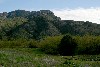 |
Rancho Sierra Vista (2 Photos)
Gallery of Site maps and photos of Rancho Sierra Vista and Satwiwa.
|
|
Trailhead Locations and Directions:
Rancho Sierra Vista/Satwiwa's Main Parking Area entrance is at the intersection of West Potrero Road and Via Goleta on the south side. Follow the entrance road to an equestrian lot or at the end of the road there are restroom facilities and a 1/4 mile trail to Satwiwa.
View Larger Map|
View Larger Map
Accessible Parking is available via the Service Entrance (Danielson Road) off Potrero Road.
View Larger Map|
View Larger Map
The Wendy Trailhead is located at the intersection of Portrero Road and Wendy Drive. It is the only parking area that is available after sunset.
View Larger Map|
View Larger Map
8 Mile Hike to the Beach- Sycamore Cove Parking Area can be used for to begin an 8 mile hike to Satwiwa. But, most visitors prefer to park a car at the cove (A) and then take a second car to the Rancho Sierra Vista Main Entrance at Via Goleta (B). From there you can take the 8 mile hike to Ocean, have a picnic on the beach and then return to your other vehicle.
View Larger Map|
View Larger Map
|
|  | | |
|
|
|
|
|
|
|
 |
|
Did You Know?
Santa Monica Mountains National Recreation Area was established in 1978, but the National Park Service did not own public parkland in the area until 1980. National Park Rangers devised clever ways to promote the national park goals without land by creating thriving partnerships with many agencies.
|
|
|
|
Last Updated: April 17, 2009 at 12:24 EST |