Observations | Weekly/Divisonal Data | General Information | Awards
Cooperative Weather
Observations and Summaries
Observers - Do you want to submit your reports online?
Click here for information on the Weather Coder (WxCoder).
All data on this page is preliminary and subject to revision
Latest COOP Observations (Text) Received through NWS Sioux Falls
- Decoded Weather Observations
- Coded Weather Observations through NWS Sioux Falls (RR3FSD)
Daily Temperature/Precipitation Maps and Tables (usually updated by 11 am)
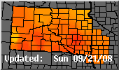 24 Hour High Temperature |
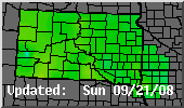 24 Hour Low Temperature |
 24 Hour Precipitation |
 24 Hour Snowfall |
 Daily Snow Depth |
Click Maps to Enlarge. Please Note Date/Time |
Soil Temperatures
- Soil Temperature Maps for South Dakota
- Max/Min 4 inch Soil Temperature Map for Iowa
Weekly/Divisional Climate Data
Weekly Averages |
National Snow Graphics/Data
|
Crop Weather Reports |
Agricultural Maps and Data |