 |
 | |
  | |
|
|
|
|
Historic Jamestowne
Directions
|
|
|
|
|
|
 |
 |
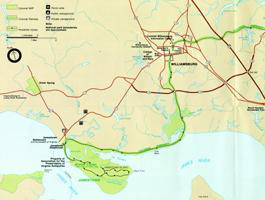
| NPS Image | | Park map showing the route from Colonial Williamsburg to Jamestown |
 |
Situated on the banks of the James River, Jamestown is a short distance from many major roadways and highways. For a google map search use the following address: 1368 Colonial Parkway, Jamestown, Virginia 23081.
FROM INTERSTATE 64 (I-64)
When traveling east or west on I-64 take exit 242A (Route 199 West). At the second stoplight, S. Henry Street, turn right. Make another immediate second right, about 50 feet from the first right. This will take you to the Colonial Parkway. Turn right onto the Parkway and follow it to its end and the Jamestown Entrance Station. Welcome to Jamestown.
FROM WILLIAMSBURG
Take the Colonial Parkway towards Jamestown, again following it to its end. An Alternate route is to take Jamestown Road, Route 31, south towards the James River. Turn left just before the Jamestown Beach Campsite and follow the road around the Jamestown Settlement, a state living history park dedicated to Jamestown, Parking Lot until you come to a stop sign. Turn right onto the Colonial Parkway. One hundred yards down the road is the Jamestown Entrance Station. Again, welcome to Jamestown.
FROM THE YORKTOWN AREA
Take the Colonial Parkway all the way to its end at the Jamestown Entrance Station. It's just the easy. Have a pleasant visit.
|
|  |  |

|
 |
|
|
|
|
|
 |
|
Did You Know?
Dendrochronology, the study of tree rings, indicates the Jamestown colonists arrived during the worst drought period in over 800 years for the lower Chesapeake Bay area of Virginia.
|
|
|
|
Last Updated: April 30, 2007 at 16:38 EST |


