| Home >> | Advanced Search >> |
 |
|
Astronaut Photography of Earth - Display Record
ISS017-E-6184
Low-resolution Browse Image
(Most browse images are not color adjusted.)Images
Conditions for Use of Images >>Image Transformation Tutorial >> Saving, Color Adjusting, and Printing Images >>
Images to View on Your Computer Now
| File Name | File Size (bytes) | Width | Height | Annotated | Cropped | Purpose | Comments | |
|---|---|---|---|---|---|---|---|---|
| View | ISS017-E-6184.JPG | 108420 | 639 | 436 | No | No | ||
| View | ISS017-E-6184.JPG | 290442 | 540 | 372 | Yes | Yes | NASA's Earth Observatory web site |
Large Images to Request for Downloading
| File Name | File Size (bytes) | Width | Height | Annotated | Cropped | Purpose | Comments | |
|---|---|---|---|---|---|---|---|---|
| Request | ISS017-E-6184.JPG | 833766 | 1000 | 689 | No | Yes | NASA's Earth Observatory web site | |
| Request | ISS017-E-6184.JPG | 1545081 | 3072 | 2096 | No | No |
Download a Keyhole Markup Language (KML) file for use in Google Earth.
Electronic Image Data
Camera Files >> No sound file available.Identification
Mission: ISS017 Roll: E Frame: 6184 Mission ID on the Film or image: ISS017Country or Geographic Name: USA-CALIFORNIA
Features: MOUNTAIN VIEW, NASA AMES
Center Point Latitude: 37.4 Center Point Longitude: -122.0 (Negative numbers indicate south for latitude and west for longitude)
Stereo: (Yes indicates there is an adjacent picture of the same area)
ONC Map ID: JNC Map ID:
Camera
Camera Tilt: 17Camera Focal Length: 800mm
Camera: N2: Nikon D2Xs
Film: 4288E : 4288 x 2848 pixel CMOS sensor, RGBG imager color filter.
Quality
Film Exposure:Percentage of Cloud Cover: 10 (0-10)
Nadir
Date: 20080503 (YYYYMMDD)GMT Time: 191829 (HHMMSS)Nadir Point Latitude: 36.6, Longitude: -122.4 (Negative numbers indicate south for latitude and west for longitude)
Nadir to Photo Center Direction: Northeast
Sun Azimuth: 149 (Clockwise angle in degrees from north to the sun measured at the nadir point)
Spacecraft Altitude: 180 nautical miles (333 km)
Sun Elevation Angle: 67 (Angle in degrees between the horizon and the sun, measured at the nadir point)
Orbit Number: 2152
Captions
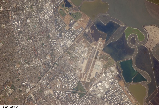
NASA Ames Research Center, Moffett Field, CAThis astronaut photograph illustrates the diverse built environment surrounding the NASA Ames Research Center located at the southernmost end of San Francisco Bay. Founded in 1939 as an aircraft research laboratory, Ames became a NASA facility in 1958. Its original aircraft research focus was enhanced by the adjacent Moffett Field—an active Naval Air Station until 1994, and the original home of the Navy dirigible U.S.S. Macon. The large hanger for docking the U.S.S. Macon is still present at Moffett Field, and is visible in this astronaut photograph (image center). Today, NASA Ames includes the former Naval Air Station, and it continues its focus on aeronautics in addition to nanotechnology, information technology, fundamental space biology, biotechnology, thermal protection systems, and human factors research.
Land use and land cover in the southern San Francisco Bay area is a diverse mix of industrial, institutional, and residential patterns. Industrial lots, characterized by lack of green vegetation and large buildings with highly reflective white rooftops, border NASA Ames to the west, east, and south. The city of Mountain View directly to the south appears as a dense gray-brown network of streets and residential properties with interspersed green parks. The northern boundary of NASA ARC consists of former salt ponds that are being restored to tidal wetlands (image right). Drainage channels that predate the salt pond levees are visible at image right.
Download Packaged File.
This option downloads the following items, packaged into a single file, if they are available:
- Browse image
- Cataloged information with captions
- Camera file
- Sound file
Server: 2 |
This service is provided by the International Space Station program. |
Recommended Citation: |
||

