NCDC | Climate | Products | Events | Search | Help
From September 21-30, 1998, Hurricane Georges left a trail of destruction in the Caribbean region and across the southern U.S. Gulf coast. Estimates indicate more than 600 people were killed (or still missing) as the storm pushed its way across the islands of the Caribbean. The Caribbean islands where preliminary death totals are reported so far include Antigua, Barbuda, St. Kitts, U.S. Virgin Islands, Puerto Rico, Dominican Republic, Haiti, Cuba, and the Bahamas. In the U.S. mainland, there were four Georges-related fatalities. An elderly woman died from heat stress while being evacuated from New Orleans. Two more people died in Florida and Louisiana in fires started by candles during power outages, and another person died as a result of an auto accident on a slick highway near Crestview, Florida. Puerto Rico reported 12 fatalities.
Damage estimates for the U.S. including Puerto Rico are now $5.9 billion. Extreme flooding was reported with rainfall amounts in excess of 20 to possibly 30 inches along portions of the southern U.S. Gulf coast. Mobile, Alabama received 13.0 inches of rain from the storm, which boosted the monthly total to 23.0 inches, breaking the September record of 16 inches set 100 years ago. The highest individual storm total reported thus far is Munson, Florida, which reported 25.0 inches of rain from Georges.
Following are reports from individual states and countries as provided by the Southeast Regional Climate Center and other sources:
Alabama: Gusts to 85 mph reported. 25-foot waves on immediate coast. 177,000 customers without power. No deaths or major injuries. Severe flooding in southern Alabama, with many homes and businesses flooded. Downtown Mobile flooded in many areas.
Florida: 18-30 inches of rain in portions of Panhandle, with NEXRAD estimates exceeding 35 inches for one small area near the AL state line. Mandatory evacuations total about 225,000. Severe flooding, high winds, and isolated tornadoes caused extensive damage. Nearly 700,000 without power at some point during storm. Approximately 200 residents in the Florida panhandle were rescued by the Coast Guard Sunday night. A portion of Interstate 10 near the Alabama border was destroyed or washed over. One death reported statewide.
On the Florida Keys, 90 mph winds were reported for >10 hours during storm passage; heavy structural damage from the storm, according to the Florida Division of Emergency Management. More than 900 homes suffered minor damage, 500 major damage, and more than 150 homes were completely destroyed, including 75 houseboats on so-called "Houseboat Row." All Key West residents were without power, and residents are under a "boil water" order. Utility restoration expected to take 7-10 days. Big Pine Key and Kudjoe Key were hardest hit, including severe storm surge damage. Since the highest elevation in the Keys is 14 feet, high water quickly swept into homes and businesses.
Puerto Rico: A major disaster. Damages estimated to exceed $2 billion. Three direct deaths; nine others from medical complications (heart attacks, etc.). Power and water out to 80% of the 3.8 million people on island. The Federal Emergency Management Agency (FEMA) estimates 33,113 homes destroyed in Puerto Rico, with nearly 50,000 more suffering major or minor damage. The storm destroyed 75 percent of the coffee crop, 95 percent of Puerto Rico's plantains, and 65 percent of its chickens.
US Virgin Islands: No deaths and little major damage was reported. Only about 20 homes were destroyed and another 50 damaged. Adherence to building codes likely prevented further damage. Most structures on the three islands had been rebuilt to FEMA standards after hits by Hugo (1989) and Marilyn (1995). Damage reported is almost solely restricted to agriculture (coconuts & mangoes) and livestock losses.
Antigua: Two dead; major structural damage island-wide; major coastal flooding; major marina, boat, and port damages.
St. Kitts & Nevis: Three dead, 3000 homeless; 85% of all homes damaged. Early damage estimate is $402 million. Infrastructure damaged (most hospitals, police stations, schools damaged); severe damage to airport terminal and control tower.
Cuba: Five dead; 2100 homes destroyed; 40,000 homes damaged. 20,000 homes flooded in Holguin Province. Major crop damage; 200,000 evacuated during and after the storm.
Haiti: 94 deaths at last tally. 60 missing. Flooding in Port-au-Prince, in Artibonite Valley, Cap-Haitien.
Dominican Republic: At least 210 dead, more than 500 missing. About 100,000 homeless. 70% of all bridges damaged or out; 90% of all plantation crops destroyed; damages estimated at more than $1 billion.
September 26-28 - Mobile (KMOB) NEXRAD - Derived 48-hour Storm Totals
September 28 - Radar Image - at 1:07 pm (CDT)
September 28 - Radar Image - at 4:57 am (CDT)
September 28 - MPEG movie - 4.7mb
September 28 - MPEG movie - 2.6mb
September 28 - Colorized IR - Center Moving Inland Over Mississippi
September 27 - Visible - Approaching Mississippi Coast
September 25 - Colorized IR - Over the Florida Keys
September 25 - Visible - Over the Florida Keys
September 22 - Visible - With Tropical Storms Ivan and Jeanne
September 22 - Visible - Striking Dominican Republic
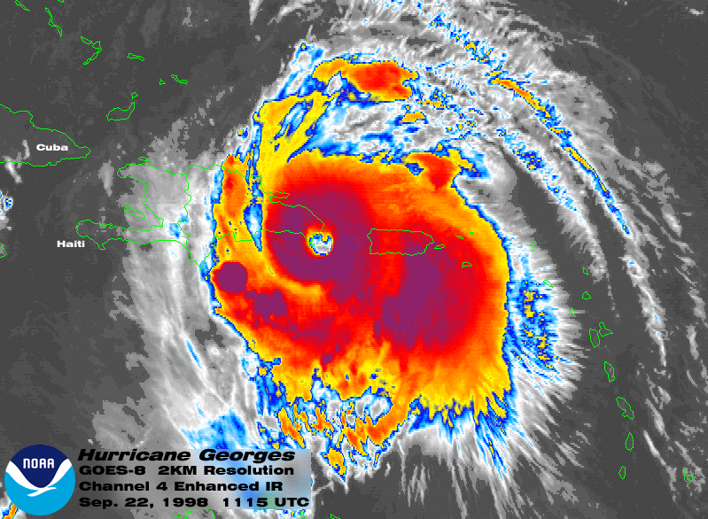
September 22 - Colorized IR - With Well Defined Eye
September 21 - Visible - Near Virgin Islands
September 18 - Visible
NESDIS Operational Significant Event Imagery
Preliminary Precipitation Reports (Based on daily rainfall data from the Climate Prediction Center)
Rainfall in affected states for 6-day period ending at 12Z on Sep 30, 1998 - amounts listed for totals exceeding 10.00:
DAYS = Number of days of data for Sep 25-30, 1998 period --
Note that some stations did not report for all 6 days
ID = National Weather Service Station ID
STATION = Station name
COUNTY = County for the station
ST = State
ELEV = Elevation in feet
LAT/LON = Latitude and Longitude in degrees and hundredths
RAINFALL = Total reported rainfall (inches) for Sep 25-30 period, ending at
12Z on the 30th

DAYS  ID     STATION              COUNTY       ST  ELEV   LAT     LON   RAINFALL
  6   CEW    CRESTVIEW            OKALOOSA     FL   190  30.78N  86.52W  20.11
  5   ALUA1  ANDALUSIA            COVINGTON    AL   250  31.30N  86.53W  19.57
  4   NCVF1  NICEVILLE            OKALOOSA     FL    60  30.52N  86.50W  19.53
  6   GVLA1  GREENVILLE           BUTLER       AL   470  31.85N  86.65W  19.30
  5   VPS    VALKARAISO           OKALOOSA     FL        30.50N  86.50W  19.19
  3   GRGA1  GEORGIANNA           BUTLER       AL   300  31.67N  86.73W  19.15
  4   HRT    MARY ESTHER          OKALOOSA     FL        30.42N  86.68W  18.01
  4   BWTA1  BREWTON              ESCAMBIA     AL    85  31.07N  87.05W  17.60
  6   DEFF1  DE FUNIAK SPRINGS    WALTON       FL   230  30.73N  86.07W  17.55
  3   OCSM6  OCEAN SPRINGS        JACKSON      MS        30.23N  88.67W  15.67
  3   WHTA1  WHATLEY              CLARKE       AL   170  31.65N  87.72W  15.15
  2   KGNA1  KINSTON              COFFEE       AL   270  31.23N  86.18W  14.27
  5   GVAA1  GENEVA               GENEVA       AL   145  31.05N  85.88W  14.25
  6   MOB    MOBILE               MOBILE       AL   204  30.68N  88.24W  13.71
  6   NPA    PENSACOLA            ESCAMBIA     FL    30  30.33N  87.30W  13.51
  5   DIBM6  D'IBERVILLE          HARRISON     MS        30.48N  88.90W  12.23
  6   BIX    BILOXI               HARRISON     MS    26  30.40N  88.92W  12.11
  5   EVRA1  EVERGREEN            CONECUH      AL   290  31.45N  86.93W  12.02
  6   CODA1  CODEN                MOBILE       AL    12  30.38N  88.23W  11.82
  6   CLDA1  COFFEEVILLE          CHOCTAW      AL    46  31.77N  88.13W  11.78
  6   BEAA1  BEATRICE             MONROE       AL   178  31.73N  87.20W  11.77
  2   GNVA1  GENEVA               GENEVA       AL   106  31.03N  85.83W  11.57
  6   CLBA1  CLAIBORNE            MONROE       AL    50  31.62N  87.55W  11.48
  6   LEKM6  LEAKESVILLE          GREENE       MS    51  31.15N  88.56W  10.65
  1   PINA1  PINE APPLE           WILCOX       AL   250  31.87N  86.98W  10.40
  6   TOMA1  THOMASVILLE          CLARKE       AL   405  31.92N  87.73W  10.20
All rainfall reports for LA, MS, AL, GA, SC, and FL
Rainfall in Puerto Rico for 2-day period ending at 12Z on Sep 23, 1998 - amounts listed for totals exceeding 10.00:
DAYS = Number of days of data for Sep 22-23, 1998 period --
Note that some stations reported only for 1 of the 2 days
ID = National Weather Service Station ID
STATION = Station name
ST = State or Territory
ELEV = Elevation in feet
LAT/LON = Latitude and Longitude in degrees and hundredths
RAINFALL = Total reported rainfall (inches) for Sep 22-23 period, ending at
12Z on the 23rd

DAYS  ID     STATION               ST  ELEV   LAT     LON   RAINFALL
  2   COMP4  COMERIO               PR   604  18.22N  66.22W  25.68
  1   JAYP4  JAYUYA                PR  1560  18.22N  66.57W  18.13
  2   CIEP4  CIDRA                 PR  1279  18.35N  66.13W  17.19
  2   RORP4  OROCOVIS              PR   500  18.22N  66.40W  16.76
  1   CAIP4  CAGUAA                PR  1475  18.13N  66.05W  15.74
  2   BAUP4  OROCOVIS              PR   773  18.23N  66.45W  14.38
  1   SLJP4  SAN LORENZO           PR   330  18.17N  65.98W  14.27
  2   PCYP4  PONCE                 PR   253  18.07N  66.58W  14.25
  1   NGIP4  NAGUABO               PR  2020  18.28N  65.78W  13.78
  2   SLKP4  SAN LORENZO           PR   490  18.15N  65.95W  13.54
  2   GUSP4  JUNCOS                PR  1115  18.25N  65.83W  13.18
  2   AIBP4  AIBONITO              PR   850  18.15N  66.22W  12.32
  2   GURP4  GURABO                PR   137  18.25N  65.97W  12.01
  2   VEDP4  RIO GRANDE            PR    40  18.36N  65.81W  11.83
  2   CAJP4  CAGUAS                PR   426  18.25N  66.10W  11.04
  2   BZAP4  CAGUAS                PR   623  18.28N  66.08W  11.03
  2   TRUP4  TRUJILLO ALTO         PR    49  18.35N  66.00W  10.92
  2   TOVP4  VILLALBA              PR   525  18.13N  66.47W  10.92
  2   ZLBP4  COAMO                 PR        18.12N  66.24W  10.90
  2   NGHP4  NAGUABO               PR   640  18.28N  65.79W  10.53
  2   LARP4  LARES                 PR   951  18.30N  66.87W  10.27
All rainfall reports for Puerto Rico
List of modern day (post 1950) hurricanes that have struck Hispaniola and/or Puerto Rico. Click on name to see track. For more information on these hurricanes visit the Satellite's Eye Gallery discussion area.
1996 - Hortense
1989 - Hugo
1987 - Emily
1980 - Allen
1979 - David
1967 - Beulah
1966 - Inez
1964 - Cleo
1963 - Flora
1963 - Edith
1958 - Ella
1956 - Betsy
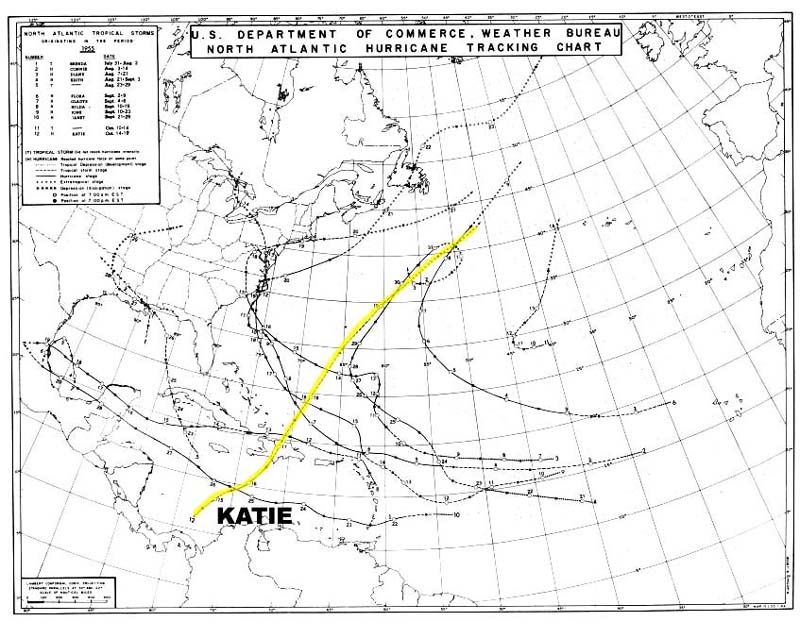
1955 - Katie
1954 - Hazel
National Hurricane Center
Storm '98 Hurricane Central
Climatic Extremes and Weather Events
Hurricanes--Climatology and Reports
 Top of Page Top of Page
http://www.ncdc.noaa.gov/oa/reports/georges/georges.html
Downloaded Saturday, 20-Sep-2008 14:36:10 EDT
Last Updated Thursday, 10-Aug-2006 14:39:42 EDT by Neal.Lott@noaa.gov, Sam.Mccown@noaa.gov, Axel.Graumann@noaa.gov, Tom.Ross@noaa.gov
Please see the NCDC Contact Page if you have questions or comments.
|

