
California Flooding and Florida Tornadoes February, 1998
|
NCDC | Contents | Climate | Products | Events | Search | Help
During the month of February 1998, California was struck by a series of storms due in part to the affects of El Nino. The current estimates indicate over $550 million in damages for the state, and 17 storm-related deaths for the winter. 35 counties were declared federal disaster areas. Clear Lake in northern California reached its highest level since 1909, flooding portions of Lakeport, about 90 miles north of San Francisco.
For further information, see the NCDC Storm Data publication for Feb 98.
February 1998 Record Rainfall Amounts (inches):
Location        Total            Former Record/Year

Ukiah           22.33             19.49 in 1958
Santa Barbara   21.74            *17.33 in 1962
UCLA            20.51            *18.37 in 1918
Chatsworth      20.11            *17.71 in 1962
Oxnard          17.80             15.58 in 1962
Simi Valley     17.20            *11.15 in 1992
Northridge      15.75            *14.23 in 1962
Monterey        15.00             11.68 in 1978
San Francisco   14.89             12.52 in 1878
L.A. Cvc Ctr    13.68             13.37 in 1884
L.A. Airport    13.30             11.07 in 1962
Lompoc          12.86             11.54 in 1918
Redwood City    12.46             10.06 in 1986
Santa Maria     11.59              9.69 in 1962
Long Beach      11.22              9.66 in 1937
San Jose        10.23              7.02 in 1915
Riverside        9.49            * 6.97 in 1969
Stockton         8.01              7.34 in 1936
Bakersfield      5.36            * 4.68 in 1978

* Denotes an all-time-record February monthly total.
..FEBRUARY AND SEASONAL RAINFALL TOTALS AND NORMALS IN INCHES FOR
   SELECTED LOCATIONS AS OF 10 AM FEB 28...

                             FEBRUARY   NORMAL     SEASON   NORMAL
..ORANGE COUNTY...
FULLERTON AIRPORT              11.50
ORANGE COUNTY AIRPORT          12.37
NEWPORT BEACH                  12.22     2.05       23.73    7.89

..SAN BERNARDINO COUNTY...
CHINO AIRPORT                  13.54

..RIVERSIDE COUNTY...
U. C. RIVERSIDE                 9.49     1.82       17.21    7.16
PALM SPRINGS                    2.19     0.84        5.75    4.54
THERMAL AIRPORT                 1.26     0.45        3.70    2.70

..SAN DIEGO COUNTY...
CARLSBAD PALOMAR AIRPORT        9.28
MIRAMAR MCAS                   11.37
MONTGOMERY FIELD                9.73
SAN DIEGO LINDBERGH FIELD       7.65     1.53       13.72    7.08
RANCHO BERNARDO NWS OFFICE      9.36                16.03
SPRING VALLEY                   8.59                17.50
BROWN FIELD AIRPORT             8.41                13.85
MT. LAGUNA                     10.21                27.61
CAMPO                           9.30     2.32       17.44   10.77

NOTE...SEASON TOTALS ARE SINCE JULY 1 1997.
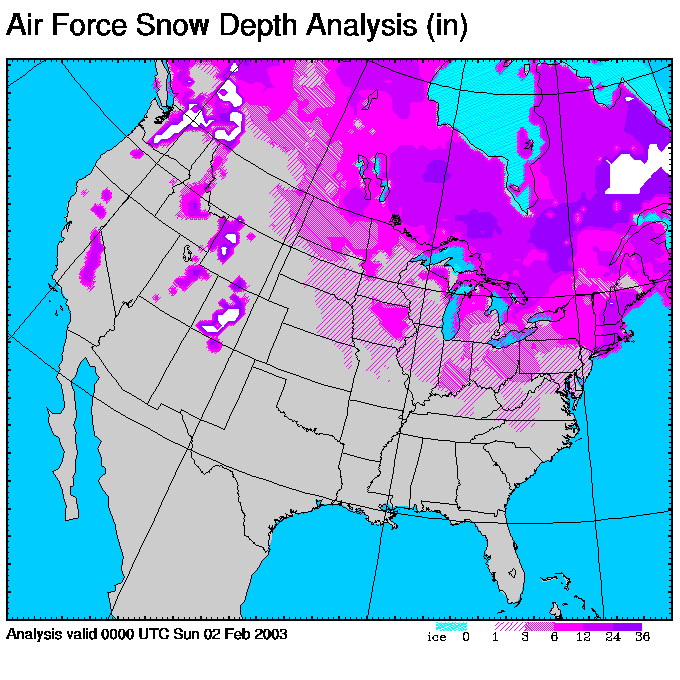
Some of the snow depths include (as reported by the National Weather Service):
SELECTED SIERRA NEVADA SNOW OBSERVATIONS
NATIONAL WEATHER SERVICE RENO NV
1000 AM PST SAT FEB 28 1998

OBSERVATIONS TAKEN BETWEEN 6 AND 9 AM PST

NORTHERN SIERRA NEVADA - LAKE TAHOE/TRUCKEE AREA
                                           NEW SNOW       SNOW DEPTH
LOCATION                 (ELEV-FT)         (INCHES)        (INCHES)
SUGAR BOWL      HWY I-80    7800                0          135-210
SQUAW VALLEY    HWY   89    8200                0              228
                            6200                0              108
ALPINE MEADOWS  HWY   89    8000                0              234
                            7000                0              114
ECHO SUMMIT     HWY   50    7382              N/A              N/A
DAGGETT PASS    HWY  207    7380                0               58
CAPLES LAKE     HWY   88    7800              N/A              N/A

SIERRA EAST SLOPES - SOUTH ALONG HWY 395 FROM BRIDGEPORT TO MAMMOTH
                                           NEW SNOW       SNOW DEPTH
LOCATION                 (ELEV-FT)         (INCHES)        (INCHES)
BRIDGEPORT                  6470                0               12
CONWAY SUMMIT               8138              N/A              N/A
LEE VINING                  6562              N/A              N/A
DEADMAN SUMMIT              8041              N/A              N/A
MAMMOTH LAKES               7500                0               68
Selected satellite images/movies from February:
(Image files larger than 50KB are indicated showing approximate size of the file. Click on each of the following to view full size images.)
Feb 2 GOES-9
Infrared Image (280KB)
|

Feb 2 GOES-9
Visible Image (440KB)
|

Feb 23 GOES-9
Infrared Image (700KB)
|

Feb 3 GOES-9
Infrared Image (280KB)
|

Feb 3 GOES-9
Visible Image (440KB)
|
Feb 23-24 GOES-9
Infrared Movie (5700KB)
|
|
Additional Reports and Data:
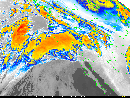
During the late evening of February 22 and early morning of February 23, 1998, a series of tornadoes ripped across central Florida. At least one of the tornadoes reached an estimated F4 intensity. Forty-two fatalities occurred, over 800 residences were destroyed, another 700 were left uninhabitable, over 3500 were damaged to some extent, and 135,000 utility customers lost power at the height of the storms. Damages from the tornado outbreak exceeded $60 million, and Florida's overall storm damage total since last fall is approximately $500 million. Hardest hit locations in the tornado outbreak were Winter Garden, Altamonte Springs, Sanford, and Campbell. Overall, 54 of Florida's 67 counties were declared federal disaster areas due to storms over the past few months.
For further information, see the NCDC Storm Data publication for Feb 98.
Selected satellite and radar images/movies:
(Image files larger than 50KB are indicated showing approximate size of the file. Click on each of the following to view full size images.)

Feb 23 GOES-8 Water
Vapor Image (700KB)
|
Feb 22-23 GOES-8
Infrared Movie (3000KB)
|

Nexrad Reflectivity, Feb
23--0356 UTC (70KB)
|

Nexrad Reflectivity, Feb
23--0455 UTC (70KB)
|

Nexrad Reflectivity, Feb
23--0550 UTC (70KB)
|
The west coast has dealt with severe flooding for each of the last four winters (including this year). However, the previous three winters were not significantly influenced by El Nino on the west coast, thus showing that (as climatologists have pointed out in prior years) severe flooding can occur on the west coast during non-El Nino years. These reports describe the previous three winters' flooding:
 Top of Page Top of Page
http://www.ncdc.noaa.gov/oa/reports/febstorm/february98storms.html
Downloaded Tuesday, 16-Sep-2008 04:27:39 EDT
Last Updated Friday, 03-Sep-2004 17:00:58 EDT by Neal.Lott@noaa.gov, Axel.Graumann@noaa.gov, Doug.Ross@noaa.gov
Please see the NCDC Contact Page if you have questions or comments.
|


