| Home >> | Advanced Search >> |
 |
|
Astronaut Photography of Earth - Display Record
ISS009-E-22625
Low-resolution Browse Image
(Most browse images are not color adjusted.)Images
Conditions for Use of Images >>Image Transformation Tutorial >> Saving, Color Adjusting, and Printing Images >>
Images to View on Your Computer Now
| File Name | File Size (bytes) | Width | Height | Annotated | Cropped | Purpose | Comments | |
|---|---|---|---|---|---|---|---|---|
| View | ISS009-E-22625.JPG | 134488 | 639 | 435 | No | No | ||
| View | ISS009-E-22625.JPG | 453029 | 540 | 451 | Yes | Yes | Earth From Space collection | |
| View | ISS009-E-22625.JPG | 1517653 | 1000 | 835 | No | Yes | NASA's Earth Observatory web site |
Large Images to Request for Downloading
| File Name | File Size (bytes) | Width | Height | Annotated | Cropped | Purpose | Comments | |
|---|---|---|---|---|---|---|---|---|
| Request | ISS009-E-22625.JPG | 2114121 | 3032 | 2064 | No | No |
Download a Keyhole Markup Language (KML) file for use in Google Earth.
Electronic Image Data
Camera Files >> No sound file available.Identification
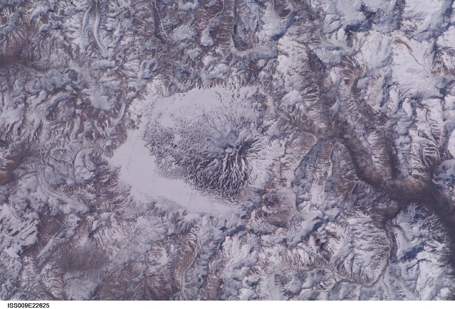
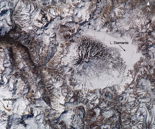
Mission: ISS009 Roll: E Frame: 22625 Mission ID on the Film or image: ISS009Country or Geographic Name: CHILE
Features: VOLCAN MAIPO, LAKE DIAMANTE
Center Point Latitude: -34.0 Center Point Longitude: -70.0 (Negative numbers indicate south for latitude and west for longitude)
Stereo: (Yes indicates there is an adjacent picture of the same area)
ONC Map ID: JNC Map ID:
Camera
Camera Tilt: 7Camera Focal Length: 180mm
Camera: E4: Kodak DCS760C Electronic Still Camera
Film: 3060E : 3060 x 2036 pixel CCD, RGBG array.
Quality
Film Exposure:Percentage of Cloud Cover: 10 (0-10)
Nadir
Date: 20040914 (YYYYMMDD)GMT Time: 181209 (HHMMSS)Nadir Point Latitude: -33.6, Longitude: -70.0 (Negative numbers indicate south for latitude and west for longitude)
Nadir to Photo Center Direction: South
Sun Azimuth: 323 (Clockwise angle in degrees from north to the sun measured at the nadir point)
Spacecraft Altitude: 198 nautical miles (367 km)
Sun Elevation Angle: 47 (Angle in degrees between the horizon and the sun, measured at the nadir point)
Orbit Number: 1238
Captions
Maipo Volcano, ChileThe high peaks of the Andes form the backbone of South America and the political border between Chile and Argentina. Formed from the subduction of the Nazca Plate under the South American Plate, the south-central Andes also includes several major volcanoes. One of the most active border volcanoes is Volcan Maipo, located just southeast of Santiago, Chile. The volcano’s summit (5264m) rests in the large Diamante Caldera, and is defined by a radial drainage pattern highlighted by snow cover (center right of image). Lava flows from an 1826 eruption blocked drainage within the caldera, forming Lake Diamante. The lake is a popular tourist destination. Maipo’s last significant eruption was in 1908.
Imagery of the region from the International Space Station includes seasonal observations—this image shows the volcano near the southern hemisphere spring equinox. The lake, just east of Maipo’s peak, is still ice covered. However, the increasing temperatures of spring are suggested by a muddy-looking streak near the lower left corner. The streak appears to be a landslide or avalanche that flowed westward down a rugged slope, possibly triggered by instability in the snowpack due to snow melt.
Download Packaged File.
This option downloads the following items, packaged into a single file, if they are available:
- Browse image
- Cataloged information with captions
- Camera file
- Sound file
Server: 2 |
This service is provided by the International Space Station program. |
Recommended Citation: |
||

