Skip all navigation and jump to content Jump to site navigation Jump to section navigation.
NASA Logo - Goddard Space Flight Center + Visit NASA.gov
HOME PROJECTS RESOURCES SEARCH MAP

+ Advanced Search
Home
Home
View Most Recently Released Imagery
View Gallery of Imagery: A topical collection of SVS Imagery
Search Imagery by the keywords assigned to it
Search Imagery by the instruments that supplied data for a visualization product
Search Imagery by the series of visualizations that have been produced
Search Imagery by the scientist providing the data used in a visualization product
Search Imagery by the animator that created the product
Search Imagery by the identification number assigned to the visualization product
See other search options
Learn about the SVS Image Server
  + About the Server
  + Animation List
  + How to Use the Server


  + RSS Feeds
blank image
Previous Animation
Next Animation
Recipe of a Hurricane (Part 1) - Sea Surface Temperature (match rendered)

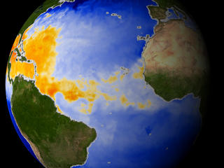
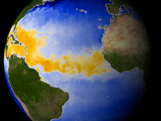
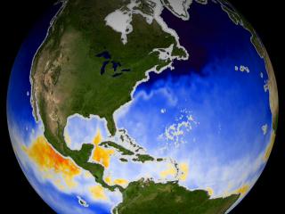
This visualization was created in support of the 'Recipe for a Hurricane' live shot campaign. This visualization shows Sea Surface Temperature as measured by the NASA Aqua satellite's Advanced Microwave Scanning Radiometer (AMSR-E) instrument. Temperature is represented by the colors in the ocean. Orange and red indicate the necessary 82-degree and warmer sea surface temperatures for a hurricane to form.

This visualization was match-frame rendered to another visualization showing GOES clouds.


This visualization shows Sea Surface Temperature as measured by the NASA Aqua satellite's Advanced Microwave Scanning Radiometer (AMSR-E) instrument.  Temperature is represented by the colors in the ocean.  Orange and red indicate the necessary 82-degree and warmer sea surface temperatures for a hurricane to form.     This visualization shows Sea Surface Temperature as measured by the NASA Aqua satellite's Advanced Microwave Scanning Radiometer (AMSR-E) instrument. Temperature is represented by the colors in the ocean. Orange and red indicate the necessary 82-degree and warmer sea surface temperatures for a hurricane to form.
Duration: 23.0 seconds
Available formats:
  720x486 (29.97 fps) Frames
  640x480 (30 fps) MPEG-1   12 MB
  720x480 (29.97 fps) MPEG-2   20 MB
  320x240 (30 fps) MPEG-1   3 MB
  320x240     JPEG         14 KB
  720x480 (29.97 fps) DV             98 MB
How to play our movies


3-30-03 AMSR-E data showing showing mostly cool waters off the African coast.    3-30-03 AMSR-E data showing showing mostly cool waters off the African coast.

Available formats:
  2560 x 1920     TIFF 4 MB
  160 x 80           PNG 42 KB
  320 x 240         JPEG 14 KB
  80 x 40             PNG 11 KB


7-13-03 AMSR-E data showing warm waters off the coast of the Africa.    7-13-03 AMSR-E data showing warm waters off the coast of the Africa.

Available formats:
  2560 x 1920     TIFF 4 MB
  320 x 240         JPEG 14 KB


None    None

Available formats:
  720 x 528         JPEG 109 KB
  320 x 234         PNG 350 KB

Animation Number:2816
Animators:Greg Shirah (SVS) (Lead)
 Jesse Allen (SVS)
Completed:2003-09-26
Scientist:Jeff Halverson (JCET UMBC)
Instrument:Aqua/AMSR-E
Data Collected:2002/06/02-2003/01/22
Series:Hurricane Live shots
Video:SVS2003-0020 *
Goddard TV Tape:G2003-051
Keywords:
SVS >> Hurricane
 
 
Please give credit for this item to
NASA/Goddard Space Flight Center
Scientific Visualization Studio


*Please note: the SVS does not fulfill requests for copies of the tapes in our library. On some of our animation pages, there is a direct link to a video distribution service from which tapes, handled by the Public Affairs Office (PAO)/Goddard TV, including some of our animations may be ordered. General information on this service can be found here.


Back to Top

USA.gov logo - the U.S. Government's official Web portal. + Privacy Policy and Important Notices
+ Reproduction Guidelines
NASA NASA Official:
SVS Contact:
Curator: