Panda Habitat Deforestation: Data
|
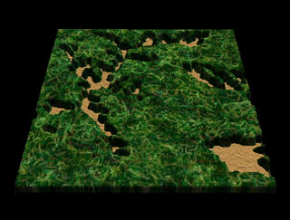
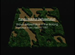
This animation uses a Landsat texture, USGS DEM data for elevation, and the Michigan State data for deforestation. Dissolve between 1965, 1974, and 1997 deforestation data sets.
|
|

|
|
Animation showing deforestation in Wolong Preserve
Duration: 21.0 seconds
Available formats:
352x240 (29.97 fps)
MPEG-1
2 MB
160x80
PNG
20 KB
320x242
JPEG
10 KB
80x40
PNG
5 KB
720x480 (29.97 fps)
DV
78 MB
How to play our movies
|
|

|
|
1965 data
Available formats:
640 x 486
TIFF
399 KB
320 x 243
JPEG
17 KB
|
|
|
|
1974 data
Available formats:
640 x 486
TIFF
396 KB
320 x 243
JPEG
17 KB
|
|

|
|
1997 data
Available formats:
640 x 486
TIFF
384 KB
320 x 243
JPEG
17 KB
|
|
|
|
None
Available formats:
720 x 528
JPEG
97 KB
320 x 234
PNG
332 KB
|
| Animation Number: | 2094 |
| Animators: | Alex Kekesi (SVS) (Lead) |
| | Lori Perkins (SVS) |
| Completed: | 2001-04-06 |
| Scientist: | Marc Linderman (Michigan State University) |
| Instruments: | CORONA/Panoramic Camera
|
| | Landsat-1/MSS |
| | Landsat-5/TM |
| Data set: | DEM (30 meter) |
| Data Collected: | Landsat 5 TM (9/27/1997), MSS Landsat 1 (1/3/1974), Corona spy satellite imagery (1/20/1965) |
| Series: | Panda Habitat Deforestation |
| Video: | SVS2001-0011 * |
Keywords:
SVS
>> Deforestation
SVS
>> Habitat
SVS
>> Landsat
SVS
>> Panda
SVS
>> Wolong
|
|
Please give credit for this item to
NASA/Goddard Space Flight Center Scientific Visualization Studio |
*Please note: the SVS does not fulfill requests for copies of the tapes in our library. On some of our animation pages, there is a direct link to a video distribution service from which tapes, handled by the Public Affairs Office (PAO)/Goddard TV, including some of our animations may be ordered. General information on this service can be found here. |
|
Back to Top
|

