Hurricane Ike on September 10, 2008 at 1745 UTC
|
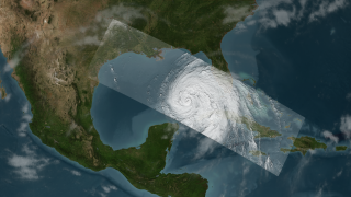
NASA's TRMM spacecraft observed this view of Hurricane Ike on September 10, 2008 at 1745 UTC or 1:45PM EST. At this time the storm was a category 2 hurricane with sustained winds of 85 knots (97.75 mph), a pressure reading of 958 millibars, and a diameter of 100 miles. The cloud cover in this animation is taken by TRMM's Visible and Infrared Scanner(VIRS) and the GOES spacecraft. The rain structure is taken by TRMM's Tropical Microwave Imager (TMI) and TRMM's Precitation Radar(PR) instruments. TRMM looks underneath of the storm's clouds to reveal the underlying rain structure. The colored isosurface uner the clouds show the rain seen by the PR instrument. This surface is colored according to cloud height where yellow represents 10 km thunderclouds and red represents 15 km or more intense thunderclouds. Ike is expected to generate a 10 to 15 foot storm surge along a 100 mile stretch of the Texas Coast from the eye landfall location.
|
|
|
|
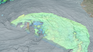
Hurricane Ike strengthens in the Gulf. TRMM observed this 17 km tower.
Duration: 28.0 seconds
Available formats:
3840x2160
TIFF
5 MB
320x180
PNG
295 KB
160x80
PNG
67 KB
80x40
PNG
17 KB
1280x720 (60 fps)
Frames
1280x720 (29.97 fps)
MPEG-4
31 MB
512x288 (30 fps)
MPEG-1
4 MB
1280x720 (30 fps)
Frames
How to play our movies
|
|
|
|
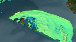
Hurricane Ike with the clouds removed.
Available formats:
3840 x 2160
TIFF
5 MB
320 x 180
PNG
257 KB
|
|
|
|
Hurricane Ike threatens the entire Gulf Coast.
Available formats:
3840 x 2160
TIFF
8 MB
320 x 180
PNG
291 KB
|
|
|
|
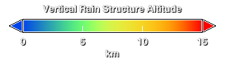
Hurricane Ike's vertical rain structure. The high towers are shown in red.
Available formats:
320 x 90
PNG
8 KB
|
|
|
Back to Top
|

