Skip all navigation and jump to content Jump to site navigation Jump to section navigation.
NASA Logo - Goddard Space Flight Center + Visit NASA.gov
HOME PROJECTS RESOURCES SEARCH MAP

+ Advanced Search
Home
Home
View Most Recently Released Imagery
View Gallery of Imagery: A topical collection of SVS Imagery
Search Imagery by the keywords assigned to it
Search Imagery by the instruments that supplied data for a visualization product
Search Imagery by the series of visualizations that have been produced
Search Imagery by the scientist providing the data used in a visualization product
Search Imagery by the animator that created the product
Search Imagery by the identification number assigned to the visualization product
See other search options
Learn about the SVS Image Server
  + About the Server
  + Animation List
  + How to Use the Server


  + RSS Feeds
  + Podcasts


  + Opportunities
blank image
Previous Animation
Next Animation
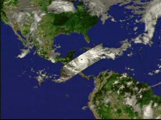
Hurricane Mitch from TRMM: October 27, 1998


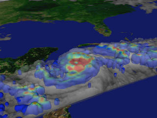
A fly-in to Hurricane Mitch on October 27, 1998, showing the three-dimensional structure of the precipitation as measured by the Precipitation Radar instrument on TRMM.  In this animation, a surface of constant precipitation is colored by the value of the precipitation on the ground under the surface.    A fly-in to Hurricane Mitch on October 27, 1998, showing the three-dimensional structure of the precipitation as measured by the Precipitation Radar instrument on TRMM. In this animation, a surface of constant precipitation is colored by the value of the precipitation on the ground under the surface.
Duration: 22.0 seconds
Available formats:
  352x240 (29.97 fps) MPEG-1   3 MB
  320x238     JPEG         13 KB
How to play our movies


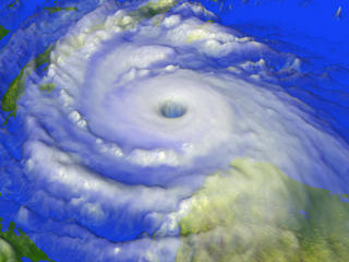
A three-dimensional view of the cloud structure of Hurricane Mitch    A three-dimensional view of the cloud structure of Hurricane Mitch

Available formats:
  2560 x 1920     TIFF 3 MB
  160 x 80           PNG       21 KB
  320 x 240         JPEG     15 KB
  80 x 40             PNG         6 KB


A perspective view of clouds and precipitation isosurfaces of Hurricane Mitch    A perspective view of clouds and precipitation isosurfaces of Hurricane Mitch

Available formats:
  2048 x 1536     TIFF 4 MB
  320 x 240         JPEG     14 KB


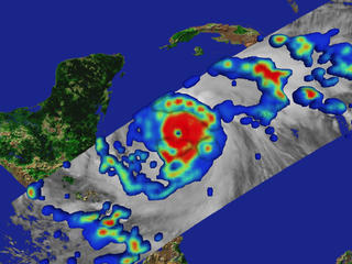
Precipitation rates on the ground superimposed on an infrared cloud image of Hurricane Mitch, measured by TRMM on October 27, 1998.  Red represents the regions of highest rainfall.    Precipitation rates on the ground superimposed on an infrared cloud image of Hurricane Mitch, measured by TRMM on October 27, 1998. Red represents the regions of highest rainfall.

Available formats:
  2048 x 1536     TIFF 2 MB
  320 x 240         JPEG     20 KB


An infrared image of Hurricane Mitch superimposed on ground precipitation rates for Hurricane Mitch, from October 27, 1998.  Red represents regions of highest rainfall.    An infrared image of Hurricane Mitch superimposed on ground precipitation rates for Hurricane Mitch, from October 27, 1998. Red represents regions of highest rainfall.

Available formats:
  2048 x 1536     TIFF 5 MB
  320 x 240         JPEG     16 KB


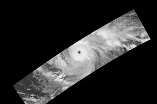
An infrared image of Hurricane Mitch taken by the VIRS instrument on TRMM on October 27, 1998    An infrared image of Hurricane Mitch taken by the VIRS instrument on TRMM on October 27, 1998

Available formats:
  1500 x 1000     GIF     383 KB
  320 x 213         JPEG       6 KB

Animation Number:220
Completed:1998-12-31
Animator:Greg Shirah (NASA/GSFC) (Lead)
Scientist:Chris Kummerow (NASA/GSFC)
Platforms/Sensors/Data Sets:GOES
 TRMM/PR
 TRMM/TMI
 TRMM/VIRS
Data Collected:1998/10/27
Series:TRMM 3D Hurricanes
Video:SVS1998-0005 *
Keywords:
DLESE >> Atmospheric science
SVS >> Hurricane
DLESE >> Natural hazards
SVS >> Hurricane Mitch
This work has been visible on
Computer Graphics World Magazine September 2000 pp. 76
 
 
Please give credit for this item to
NASA/Goddard Space Flight Center
Scientific Visualization Studio


*Please note: the SVS does not fulfill requests for copies of the tapes in our library. On some of our animation pages, there is a direct link to a video distribution service from which tapes, handled by the Public Affairs Office (PAO)/Goddard TV, including some of our animations may be ordered. General information on this service can be found here.


Back to Top

USA.gov logo - the U.S. Government's official Web portal. + Privacy Policy and Important Notices
+ Reproduction Guidelines
NASA NASA Official:
SVS Contact:
Curator: