|
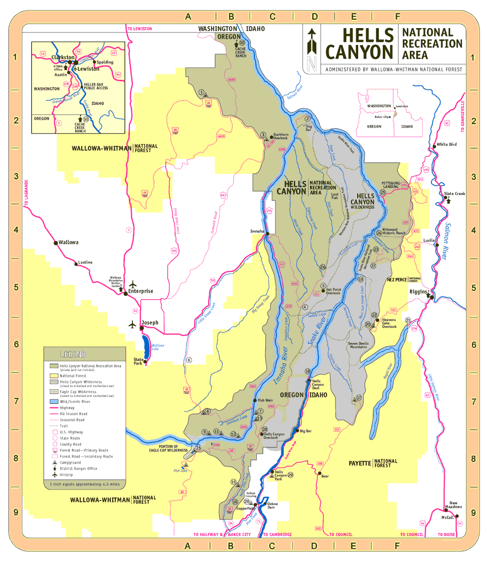
Points of Interest in Hells
Canyon NRA
- Table of Recreation Sites for Oregon
and Idaho
- Recreation Map with points of
interest
1. DOUGHERTY
45 mi NE of Enterprise OR on Forest Rd
46
No RV hookups; Open June-Nov; 10 Units
Map Location: A2
   
2. DUG BAR
Dispersed camping and picnicking; No facilities;
Trailhead for Snake River Trail;
Primitive dirt road (Forest Rd 4260)
from Imnaha is slippery when wet or frozen;
Not recommended for trailers;
Map Location: D2
    
2. NEE-ME-POO NATIONAL HISTORIC
TRAIL
3.7 mi trail; Walk in the footsteps of
Chief Joseph;
Map Location: D2
3. BUCKHORN OVERLOOK
43 mi NE of Enterprise OR on Zumwalt Rd
(County Rd 697)
and Forest Rds 46 and 46-780
Campground nearby; No RV hookups; Open June-Nov; 6 Units
Map Location: C2

4. SADDLE CREEK CAMPGROUND
17 mi from Imnaha OR on Forest Rd 4240;
Road not recommended for trailers; Open July-Nov; 7 Units;
Map Location: D5
5. HAT POINT DAY USE AREA AND OVERLOOK
23 mi from Imnaha OR on Forest Rds 4240
& 315;
Road not recommended for trailers; Open July-Nov; 6 Units
Map Location: D5

6. WALLOWA MOUNTAIN ROAD
All American Road
Scenic drive on Forest Rd 39 through National
Forest
connects towns of Joseph and Halfway OR; Open June-Nov
7. BLACKHORSE
36 miles SE of Joseph OR on Forest Rd
39;
No RV hookups; Open June-Nov; 16 Units;
Map Location: C7

8. LICK CREEK
23 miles SE of Joseph OR on Forest Rd
39;
No RV hookups; Open June-Nov; 12 Units;
Map Location: A7
9. INDIAN CROSSING
45 mi SE of Joseph OR on Forest Rds 39
& 3960
No RV hookups; Open June-Nov; 15 Units;
Map Location: A8
9. EVERGREEN
45 mi SE of Joseph OR on Forest Rds 39
& 3960;
Open June-Nov; 15 Units;
Map Location: B8
10. CACHE CREEK RANCH ADMINISTRATIVE
SITE
Northern entry to Hells Canyon River access
only;
Visitor information, river permits, and interpretive exhibits;
Open year-long;
Map Location: B1
11. HIDDEN
43 mi SE of Joseph OR on Forest Rds 39
& 3960;
No RV hookups; Open June-Nov; 10 Units;
Map Location: B8
12. COVERDALE
43 mi SE of Joseph OR on Forest Rds 39
& 3960;
Open June-Nov; 10 Units;
Map Location: B8
13. OLLOKOT
37 mi SE of Joseph OR on Forest Rd 39;
No RV hookups; Open June-Nov; 12 Units;
Map Location: B7
14. TWIN LAKES
35 mi N of Halfway OR on Forest Rd 66;
Open July-Nov; 6 Units;
Map Location: A8
15. LAKE FORK
18 mi NE of Halfway OR on Forest Rd 39;
No RV hookups; Open May-Nov; 10 Units;
Map Location: A8
16. NORTH PINE REST STOP
16 mi NE of Halfway OR on Forest Rd 39;
Open May-Nov;
Map Location: B9
17. BLACK LAKE
40 mi N of Council ID on Forest Rds 002,
105, & 112;
Access by rough, primitive road; Open late July-Sept;
High clearance vehicles recommended;
Trailers not recommended; 4 Units;
Map Location: E7
18. HELLS CANYON CREEK RECREATION
SITE
BELOW HELLS CANYON DAM
22 mi N of Oxbow OR;
Access via OR State Hwy 86 or ID State Hwy 71;
Primary launch site for float trips on Wild Snake; Jet boat tours;
Open year-long; Information Center open summers;
Map Location: D6

19. SNAKE RIVER NATIONAL RECREATION
TRAIL
A 31 mi trail paralleling the Snake River
in ID
Begins at Pittsburg Landing and ends at Granite Creek (access
by boat from Dam); Sections may be flooded in high water;
Open year-long;
Map Location: F3
20. SEVEN DEVILS
17 mi SW of Riggins ID off US Hwy 95 on
Forest Rd 517
(rough, steep road); No potable water nearby;
Trailhead for wilderness trails; Open early July-Oct; 7 Units;
Map Location: E6
21. RAPID RIVER FISH HATCHERY
6 mi SW of Riggins ID off US Hwy 95; Operated
by Idaho Power
Company; Guided tours; Open daily;
Map Location: F6
22. HEAVENS GATE OVERLOOK
19 mi W of Riggins ID off US Hwy 95 on
Forest Rd 517
(rough, steep road); Elevation 8400 ft; Open July-Sept;
Map Location: F6
22. HEAVENS GATE SCENIC TRAIL
1/2 mile trail access to overlook; Medium
slope, but strenuous
due to elevation; Open July-Sept;
Map Location: F6
23. SAW PIT SADDLE VIEWPOINT
Access via primitive dirt and gravel Forest
Rd 241 off
US Hwy 95 near Riggins; Open June-Nov;
Map Location: F4
24. KIRKWOOD HISTORIC RANCH
Museum exhibits early canyon life; Access
by foot or boat;
Visitors welcome; Open year-long;
Map Location: F4
25. PITTSBURG
LANDING
17 mi SW of White Bird ID off US Hwy 95
on Forest Rd 493;
Trailhead for Snake River Nat'l Rec Trail;
Steep access road is slippery when wet; Open year-long;
Map Location: F3
More Info
26. WARNOCK CORRALS
60 mi NE of Joseph OR on Forest Rd 4240;
Road not recommended for trailers;
Last 5 miles is rough, primitive road; Open July-Nov;
Map Location: D5
27. LOW SADDLE VIEWPOINT
Access via primitive dirt and gravel Forest
Rd 241
off US Hwy 95 near Riggins; Open June-Nov;
Map Location: E4
28. HELLS CANYON OVERLOOK
30 mi NE of Halfway or 43 mi SE of Joseph
on Forest Rds 39 & 3965;
Easiest access for view into Hells Canyon country; Open June-Nov;
Map Location: C8
29. COPPERFIELD
At OR State Highway 86 and Oxbow Crossing
(62 RV sites and 10 tent sites).
and at Hells Canyon Park 7
miles north of Oxbow Crossing (24 RV sites and 5 designated tent
sites).
Developed sites provided by Idaho Power Company
1.800.422.3143 in Idaho; 1.800.521.9102 outside Idaho;
Open all year;
Map Location: C9
|


