Skip all navigation and jump to content Jump to site navigation Jump to section navigation.
NASA Logo - Goddard Space Flight Center + Visit NASA.gov
HOME PROJECTS RESOURCES SEARCH MAP

+ Advanced Search
Home
Home
View Most Recently Released Imagery
View Gallery of Imagery: A topical collection of SVS Imagery
Search Imagery by the keywords assigned to it
Search Imagery by the instruments that supplied data for a visualization product
Search Imagery by the series of visualizations that have been produced
Search Imagery by the scientist providing the data used in a visualization product
Search Imagery by the animator that created the product
Search Imagery by the identification number assigned to the visualization product
See other search options
Learn about the SVS Image Server
  + About the Server
  + Animation List
  + How to Use the Server


  + RSS Feeds
blank image
Previous Animation
Next Animation
NAMMA Aircraft Flights from Cape Verde

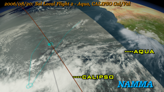
The NASA African Monsoon Multidisciplinary Analysis (NAMMA) campaign was a field research campaign to study African Easterly waves off the western coast of Africa. A DC-8 aircraft was flown out of the island of Sal, Cape Verde, in August and September 2006, and was outfitted with atmospheric sensors that measured data in this region that could be compared with satellite, balloon, and ground-based sensors to build up a comprehensive picture of the atmosphere in this region. This region is important in that it is one of the primary regions of tropical cyclogenesis, where Atlantic hurricanes form. This animation shows all the flight paths of the DC-8 during this campaign along with the corresponding cloud and satellite data from satellites.

An animation of the NAMMA mission aircraft flights out of Sal, Cape Verde with satellite flight tracks indicated.    An animation of the NAMMA mission aircraft flights out of Sal, Cape Verde with satellite flight tracks indicated.
Duration: 1.5 minutes
Available formats:
  960x540 (29.97 fps) MPEG-4   36 MB
  640x360 (29.97 fps) MPEG-4   20 MB
  1280x720 (29.97 fps) MPEG-4   61 MB
  1280x720 (29.97 fps) Frames
  512x288 (29.97 fps) MPEG-1   31 MB
  320x180     PNG           299 KB
  160x80       PNG           69 KB
  80x40         PNG           17 KB
How to play our movies

Animation Number:3419
Animators:Horace Mitchell (SVS) (Lead)
 Greg Shirah (SVS)
Completed:2007-04-23
Scientist:Anthony Guillory (NASA/GSFC Wallops)
Instruments:Aqua/MODIS
 Terra/MODIS
 CALIPSO/CALIOP
 CloudSat/CPR
Data sets:Blue Marble landcover
 Cloud Cover
 Visible
Data Collected:2006/08/15 - 2006/09/14
Keywords:
SVS >> HDTV
GCMD >> EARTH SCIENCE >> Spectral/Engineering >> Platform Characteristics >> Airspeed/Ground Speed
GCMD >> EARTH SCIENCE >> Spectral/Engineering >> Platform Characteristics >> Orbital Characteristics
 
 
Please give credit for this item to
NASA/Goddard Space Flight Center Scientific Visualization Studio

Additional Credits:
NCEP Cloud Composite courtesy of NOAA's Climate Prediction Center.


Back to Top

USA.gov logo - the U.S. Government's official Web portal. + Privacy Policy and Important Notices
+ Reproduction Guidelines
NASA NASA Official:
SVS Contact:
Curator: