Global Rotation showing Seasonal Landcover and Arctic Sea Ice
|
In this animation, the globe slowly rotates one full rotation while seasonal land cover and Arctic sea ice vary through time. The animation begins on September 21, 2005 when sea ice in the Arctic was at its minimum extent, and continues through September 20, 2006. This time period repeats six times during the animation, playing at a rate of day frame per frame. Over the terrain, monthly data from the seasonal Blue Marble Next Generation fades slowly from month to month. Over the water, Arctic sea ice changes from day to day.
|
|

|
|
This animation shows seasonal changes in landcover and Arctic sea ice from 2005-09-21 through 2006-09-20.
Duration: 1.2 minutes
Available formats:
1280x720 (29.97 fps)
Frames
320x180
PNG
41 KB
160x80
PNG
12 KB
80x40
PNG
3 KB
1280x720 (30 fps)
MPEG-2
64 MB
1280x720 (29.97 fps)
MPEG-4
8 MB
512x288 (30 fps)
MPEG-1
11 MB
How to play our movies
|
|

|
|
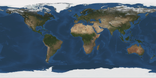
This WMS frame set contains a cartesian projection of each day from 2005-09-21 through 2006-09-20.
Available formats:
2048x1024 (29.97 fps)
Frames
320x160
PNG
69 KB
How to play our movies
|
|
This product is available through our Web Map Service.
Click here to learn more.
|
|
|
|
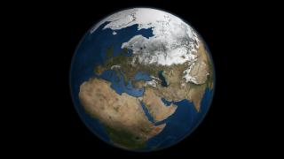
This image presents a global view over Europe and Scandinavia with Arctic sea ice shown on March 9, 2006. Land areas display the average seasonal landcover from March, 2004.
Available formats:
2560 x 1920
TIFF
4 MB
320 x 240
PNG
70 KB
|
|

|
|
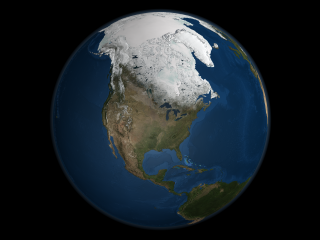
This image presents a global view over North America with Arctic sea ice shown on April 8, 2006. Land areas display the average seasonal landcover from April, 2004.
Available formats:
2560 x 1920
TIFF
3 MB
320 x 240
PNG
58 KB
|
|

|
|
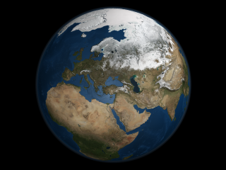
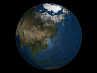
This image presents a global view over Asia with Arctic sea ice shown on September 21, 2005. - the day on which the sea ice was at the minimum extent for the year. Land areas display the average seasonal landcover from September, 2004.
Available formats:
2560 x 1920
TIFF
3 MB
320 x 240
PNG
63 KB
|
|
|
Back to Top
|

