Loop of AMSR-E Daily Arctic Sea Ice from Aug 2005 to Aug 2006
|
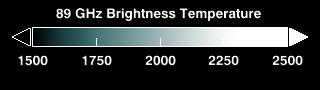
Sea ice is frozen seawater floating on the surface of the ocean. Some sea ice is permanent, persisting from year to year, and some is seasonal, melting and refreezing from season to season. Sea ice is almost always in motion, reacting to ocean currents and to winds. The AMSR-E instrument on the Aqua satellite acquires high resolution measurements of the 89 GHz brightness temperature near the poles. Because this is a passive microwave sensor and independent of atmospheric effects, this sensor is able to observe the entire polar region every day, even through clouds and snowfalls. This animation of AMSR-E 89 GHz brightness temperature in the northern hemisphere during late 2005 and early 2006 clearly shows the dynamic motion of the ice as well as its seasonal expansion and contraction. This animation shows the seasonal advance and retreat of sea ice over the Arctic from 8/5/2005 through 8/4/2006. The false color of the sea ice, derived from the AMSR-E 6.25 km 89 GHz brightness temperature, highlights the fissures in the sea ice by showing warmer areas of ice in a deeper blue and colder areas of sea ice in a brighter white. The sea ice extent is defined by a three-day moving average of the AMSR-E 12.5 km sea ice concentration, showing as ice all areas having a sea ice concentration greater than 15%.
|
|
|
|
This animation shows the seasonal advance and retreat of sea ice over the Arctic from 8/5/2005 through 8/4/2006. The yearly cycle is repeated three times while the camera circles the Arctic, providing a view of the sea ice from a wide range of viewpoints.
Duration: 2.0 minutes
Available formats:
1280x720 (29.97 fps)
Frames
1280x720
TIFF
1 MB
320x180
PNG
87 KB
160x80
PNG
22 KB
80x40
PNG
6 KB
256x144 (30 fps)
MPEG-1
17 MB
512x288 (30 fps)
MPEG-1
48 MB
720x480 (29.97 fps)
MPEG-2
90 MB
1280x720 (29.97 fps)
MPEG-4
113 MB
1280x720 (29.97 fps)
MPEG-2
271 MB
How to play our movies
|
|
|
|
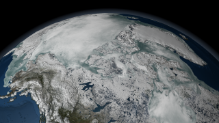
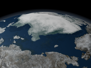
This image shows the sea ice above North America on 04/26/2006.
Available formats:
2560 x 1920
TIFF
10 MB
320 x 240
PNG
123 KB
|
|
|
|
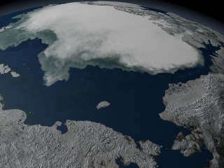
This image shows the Arctic sea ice north of Russia on 10/09/2005, as viewed from over the East Siberian Sea.
Available formats:
2560 x 1920
TIFF
10 MB
320 x 240
PNG
106 KB
|
|
|
|
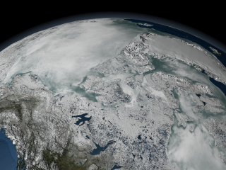
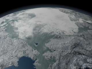
This image shows the Arctic sea ice above North America on 09/27/2005, viewed over the Beaufort Sea.
Available formats:
2560 x 1920
TIFF
10 MB
320 x 240
PNG
119 KB
12000 x 9000
TIFF
182 MB
|
|
|
|
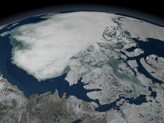
This image shows the Arctic sea ice north of Russia on 09/27/2005, as viewed from over the East Siberian Sea.
Available formats:
12000 x 9000
TIFF
89 MB
320 x 240
PNG
104 KB
2560 x 1920
TIFF
5 MB
|
|
|
|
This image shows the Arctic sea ice on 12/01/2005 as viewed from the Bering Strait.
Available formats:
2560 x 1920
TIFF
10 MB
320 x 240
PNG
116 KB
|
|
|
|
This image shows the color bar applied to the AMSR-E brightness temperature data.
Available formats:
320 x 90
PNG
12 KB
|
|
|
Back to Top
|

