Seasonal Landcover Change over Eastern Asia in 2004
|
The Blue Marble Next Generation data set provides a monthly global cloud-free true-color picture of the Earth's land cover at a 500-meter spatial resolution. This visualization of the data set shows seasonal variations such as snowfall, spring greening and droughts in a seamless fashion, thereby heightening awareness of changes in the Earth's climate. Here we focus on the seasonal land cover changes over the Eastern Asia. This data set is derived from imagery taken in 2004 by the MODIS instrument on the Terra satellite.
|
|
|
|
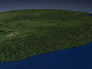
This animation shows seasonal landcover changes over Northeastern China (left) and Southeastern Russia (right), viewed from the vantage point of the Sea of Japan. The black line marks the border between China and Russia.
Duration: 18.0 seconds
Available formats:
320x240 (30 fps)
MPEG-1
2 MB
640x480 (30 fps)
MPEG-1
9 MB
320x240
JPEG
11 KB
160x80
PNG
16 KB
80x40
PNG
4 KB
720x480 (29.97 fps)
MPEG-2
15 MB
720x486 (29.97 fps)
Frames (Landcover)
How to play our movies
|
|
|
|
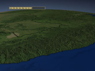
This animation shows seasonal landcover changes over Northeastern China (left) and Southeastern Russia (right), viewed from the vantage point of the Sea of Japan. The black line marks the border between China and Russia. This version has a date bar to indicate the month being shown.
Duration: 18.0 seconds
Available formats:
320x240
JPEG
11 KB
160x80
PNG
16 KB
80x40
PNG
4 KB
320x240 (30 fps)
MPEG-1
2 MB
640x480 (30 fps)
MPEG-1
9 MB
720x480 (29.97 fps)
MPEG-2
15 MB
720x486 (29.97 fps)
Frames (DateOverlay)
720x486 (29.97 fps)
Frames (LandcoverWdate)
How to play our movies
|
|
|
|
This animation shows seasonal landcover changes over Northeastern China (left) and Southeastern Russia (right), viewed from the vantage point of the Sea of Japan. The black line marks the border between China and Russia. This version is in HD widescreen format.
Duration: 20.0 seconds
Available formats:
640x360 (59.94 fps)
MPEG-1
9 MB
1280x720 (59.94 fps)
Frames (DateOverlay)
1280x720 (59.94 fps)
Frames (Landcover)
1280x720 (59.94 fps)
Frames (LandcoverWdate)
320x180
PNG
74 KB
1280x720 (60 fps)
MPEG-2
44 MB
How to play our movies
|
|

|
|
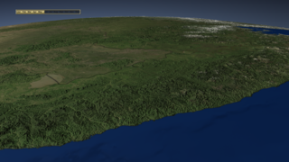
This image shows landcover over Northeastern China (left) and Southeastern Russia (right) in August 2004, viewed from the vantage point of the Sea of Japan. The black line marks the border between China and Russia.
Available formats:
2560 x 1920
TIFF
5 MB
320 x 240
JPEG
11 KB
80 x 40
PNG
7 KB
160 x 80
PNG
20 KB
|
|
|
Back to Top
|

