|
|
 |
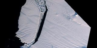
Pine Island Glacier Calving (WMS)
|
The Pine Island Glacier is the largest discharger of ice in Antarctica and the continent's fastest moving glacier. Even so, when a large crack formed across the glacier in mid 2000, it was surprising how fast the crack expanded, 15 meters per day, and how soon the resulting iceberg broke off, mid-November, 2001. This iceberg, called B-21, is 42 kilometers by 17 kilometers and contains seven years of glacier outflow released to the sea in a single event. This series of images from the MISR instrument on the Terra satellite not only shows the crack expanding and the iceberg breaking off, but the seaward moving glacial flow in the parts of the Pine Island Glacier upstream of the crack.
|
|
|
|
Breakoff of iceberg B-21 from the Pine Island glacier shown in imagery acquired by MISR
Duration: 1.0 seconds
Available formats:
512x512 (29.97 fps)
MPEG-1
237 KB
160x80
PNG
15 KB
320x160
JPEG
6 KB
80x40
PNG
4 KB
How to play our movies
|
|
This product is available through our Web Map Service.
Click here to learn more.
|
| Animation Number: | 3127 |
| Animators: | Lori Perkins (SVS) (Lead) |
| | Horace Mitchell (SVS) |
| Completed: | 2005-03-09 |
| Scientists: | Bob Bindschadler (NASA/GSFC) |
| | Dave Diner (NASA/JPL CalTech) |
| Instrument: | Terra/MISR |
| Data Collected: | 2000/09/16, 2000/11/28, 2000/12/12, 2001/01/01, 2001/01/22, 2001/02/25, 2002/090/08, /2001/10/10, 2001/10/26, 2001/11/04, 2001/11/09, 2001/11/11, 2001/11/12 |
| Series: | WMS |
Keywords:
DLESE
>> Cryology
GCMD
>> EARTH SCIENCE
>> Cryosphere
>> Glaciers/Ice Sheets
>> Icebergs
GCMD
>> EARTH SCIENCE
>> Cryosphere
>> Sea Ice
>> Icebergs
GCMD
>> EARTH SCIENCE
>> Cryosphere
>> Sea Ice
>> Sea Ice Motion
|
 Google Earth KML file is available here.
 |
| DEPC Metadata is available here. |
|
Please give credit for this item to
NASA/Goddard Space Flight Center
Scientific Visualization Studio |
|
Back to Top
|
|
|
|

