ICESat First Light Release: Antarctica, from Coast to Coast
|
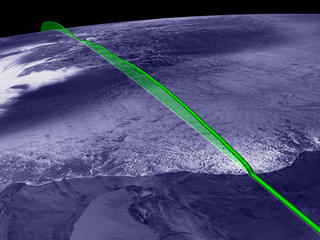
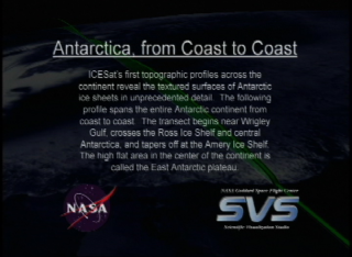
ICESat's first topographic profiles across the continent reveal the textured surfaces of Antarctic ice sheets in unprecedented detail. The following profile spans the entire Antarctic continent from coast to coast. The transect begins near Wrigley Gulf, crosses the Ross Ice Shelf and central Antarctica, finally tapering off at the Amery Ice Shelf. The high flat area in the center of the continent is called the East Antarctic plateau.
|
|
|
|
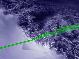
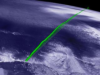
Animation showing an ICESat elevation data pass (in green) starting near Wrigley Gulf, passing over the East Antarctic plateau, ending near the Amery Ice Shelf.
Duration: 2.2 minutes
Available formats:
320x240 (30 fps)
MPEG-1
18 MB
320x214
JPEG
10 KB
720x486 (29.97 fps)
Frames
720x480 (29.97 fps)
DV
478 MB
How to play our movies
|
|
|
|
A slice of ICESat elevation data (170 meter post-spaced) near the Amery coast laying over a flat RADARSAT texture.
Available formats:
2560 x 1920
TIFF
14 MB
160 x 80
PNG
19 KB
320 x 240
JPEG
15 KB
80 x 40
PNG
5 KB
|
|
|
|
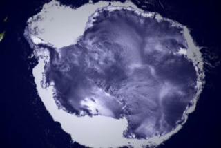
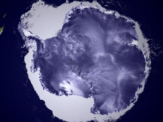
A birds eye view of the Antarctic continent surrounded by sea ice.
Available formats:
2560 x 1920
TIFF
14 MB
320 x 240
JPEG
13 KB
|
|
|
|
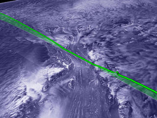
A slice of (green) elevation data passing over Lambert Glacier.
Available formats:
2560 x 1920
TIFF
14 MB
320 x 240
JPEG
19 KB
|
|
|
|
Another slice of elevation data near the Ross Ice Shelf.
Available formats:
2560 x 1920
TIFF
14 MB
320 x 240
JPEG
19 KB
|
|
|
|
A slice of elevation data near the Wrigley Gulf coastline.
Available formats:
2560 x 1920
TIFF
14 MB
320 x 240
JPEG
14 KB
|
|
|
|
None
Available formats:
720 x 528
JPEG
114 KB
320 x 234
PNG
342 KB
|
| Animation Number: | 2741 |
| Animators: | Alex Kekesi (Lead) |
| | Greg Shirah |
| Studio: | NASA |
| Completed: | 2003-05-23 |
| Scientists: | Chris Shuman (NASA/GSFC) |
| | Jay Zwally (NASA/GSFC) |
| Instruments: | ICESat/GLAS
|
| | RADARSAT-1/SAR |
| | Terra/MODIS |
| Data set: | ICESat/GLAS Elevation |
| Data Collected: | ICESat/GLAS:2003/02/22, Terra/MODIS:2001/06-2001/09, RADARSAT:1997/09/26-1997/11/04 |
| Series: | ICESat |
| Video: | SVS2003-0015 * |
Keywords:
SVS
>> Laser
GCMD
>> EARTH SCIENCE
>> Land Surface
>> Topography
>> Terrain Elevation
|
|
Please give credit for this item to
NASA/Goddard Space Flight Center
Scientific Visualization Studio, Canadian Space Agency, RADARSAT International Inc. |
*Please note: the SVS does not fulfill requests for copies of the tapes in our library. On some of our animation pages, there is a direct link to a video distribution service from which tapes, handled by the Public Affairs Office (PAO)/Goddard TV, including some of our animations may be ordered. General information on this service can be found here. |
|
Back to Top
|

