LATEST FEATURED IMAGE FROM ASTER: |
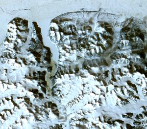
Northern Greenland
The northernmost land in the world is located in Pearyland, Greenland, at a latitude of 83 degrees, 39.6 minutes. Updated on 9/15/2008
ASTER (Advanced Spaceborne Thermal Emission and Reflection Radiometer) is an imaging instrument flying on Terra, a satellite launched in December 1999 as part of NASA's Earth Observing
System (EOS). ASTER is a cooperative effort between NASA, Japan's Ministry of Economy, Trade
and Industry (METI) and Japan's Earth Remote Sensing Data Analysis Center
(ERSDAC). ASTER
is being
used to obtain detailed maps of land surface temperature, reflectance and elevation.
The three EOS platforms are part of NASA's Science Mission Directorate and the
Earth-Sun System,
whose goal is to observe, understand, and model the Earth system to discover
how it is changing, to better predict change, and to understand the
consequences for life on Earth.
Home
|