Minimum Sea Ice Extent (WMS)
|
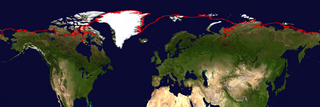
Each year, the ice covering the Arctic Ocean grows during the northern hemisphere winter and shrinks with the northern hemisphere summer. The ice extent is usually greatest during the month of March and is the least during the month of September. This image shows the average minimum extent of sea ice over the northern hemisphere during the month of September over 24 seasons, from 1979 - 2002. The red line shows the area where the average sea ice concentration is 15%.
|
|
|
|
These images show the minimum extent of sea ice in the northern hemisphere. There are several images available, including a transparent overlay, a background image from NASA's Blue Marble, and a composite image.
Available formats:
1200 x 400
PNG
469 KB
1200 x 400
PNG
479 KB
80 x 40
PNG
6 KB
320 x 107
PNG
46 KB
1200 x 400
PNG
36 KB
160 x 80
PNG
19 KB
|
|
This product is available through our Web Map Service.
Click here to learn more.
|
|
|
|
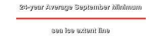
Legend for the September minimum sea ice extent.
Available formats:
320 x 90
PNG
9 KB
|
|
|
Back to Top
|

